Reply With Quote
I thought you were just a bakery!Originally Posted by tilt


I thought you were part of Holland??
Daniel the Neon Knight: Campaign Cartographer User
Never use a big word when a diminutive one will suffice!
Any questions on CC3? Post them with CC3 in the Subject Line!
MY 'FAMOUS' CC3 MAPS: Thunderspire; Pyramid of Shadows; King of the Trollhaunt Warrens; Demon Queen's Enclave
I thought you were just a bakery!
Hi ho, hi ho, it's off to work I go..


*lol*... we are good at that
regs tilt
:: My DnD page Encounter Depot free stuff for your game :: My work page Catapult ::
:: Finished Maps :: Competion maps - The Island of Dr. Rorshach ::
:: FREE Tiles - Compasses :: Other Taking a commision - Copyright & Creative Commons ::
Works under CC licence unless mentioned otherwise

Hi,
I like your risk style maps, how you create it? Can you explain some steps to create it? I preparing a map for a game like risk.
Salut,
Josep M


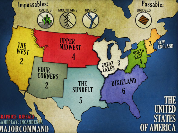
Man - that's a big question. For starters, I use google earth or maps for a base region that I want. For the maps I make, I can't use ALL the political or regional borders, it just wouldn't work. I try to use at least some sort of real borders though. I create all the borders in illustrator, because it's easier for me to warp them around that way. And for risk maps, you never want a 4-way border, you know - like an X. People don't know for sure if they can attack diagonal - so it's best to keep clear borders. Borders take a long time - because you have to think about gameplay, bonus regions, how many regions border each other.. it's tough, and really the key to a good game.
After that, I import the borders into photoshop and start the graphics. My maps are created for online games, so there is a smaller resolution i work with - like 1000 px x 600 px usually. But I create my maps at double that size (2000x1200) because it's easier to get some details in that size. I usually have about 75 layers in a finished map. Lots of grunge, and overlays and tiny effects that nobody would probably ever notice.
Hope that at least gives you an idea - it's a long process. But rewarding when you can play a game on your map
Good Luck - you can hit me up in this thread if you have specific problems and I can try to help.
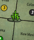
Example of 4-way border - This area of the US is known as the 4-corners because the state borders form a cross. I couldn't warp those borders, it just wouldn't work, so I dropped some cacti in there. It's a desert region anyway, so it worked.
then I make sure to put that symbol in the legend (or brief as we call them).
Last edited by RjBeals; 12-20-2010 at 09:55 PM.
 Posting Permissions