

 Reply With Quote
This is looking really good. I don't see any problems with the rivers (!! I am not a riverologist !!). What is the scale? Is this a big island, a continent? What are those circles?


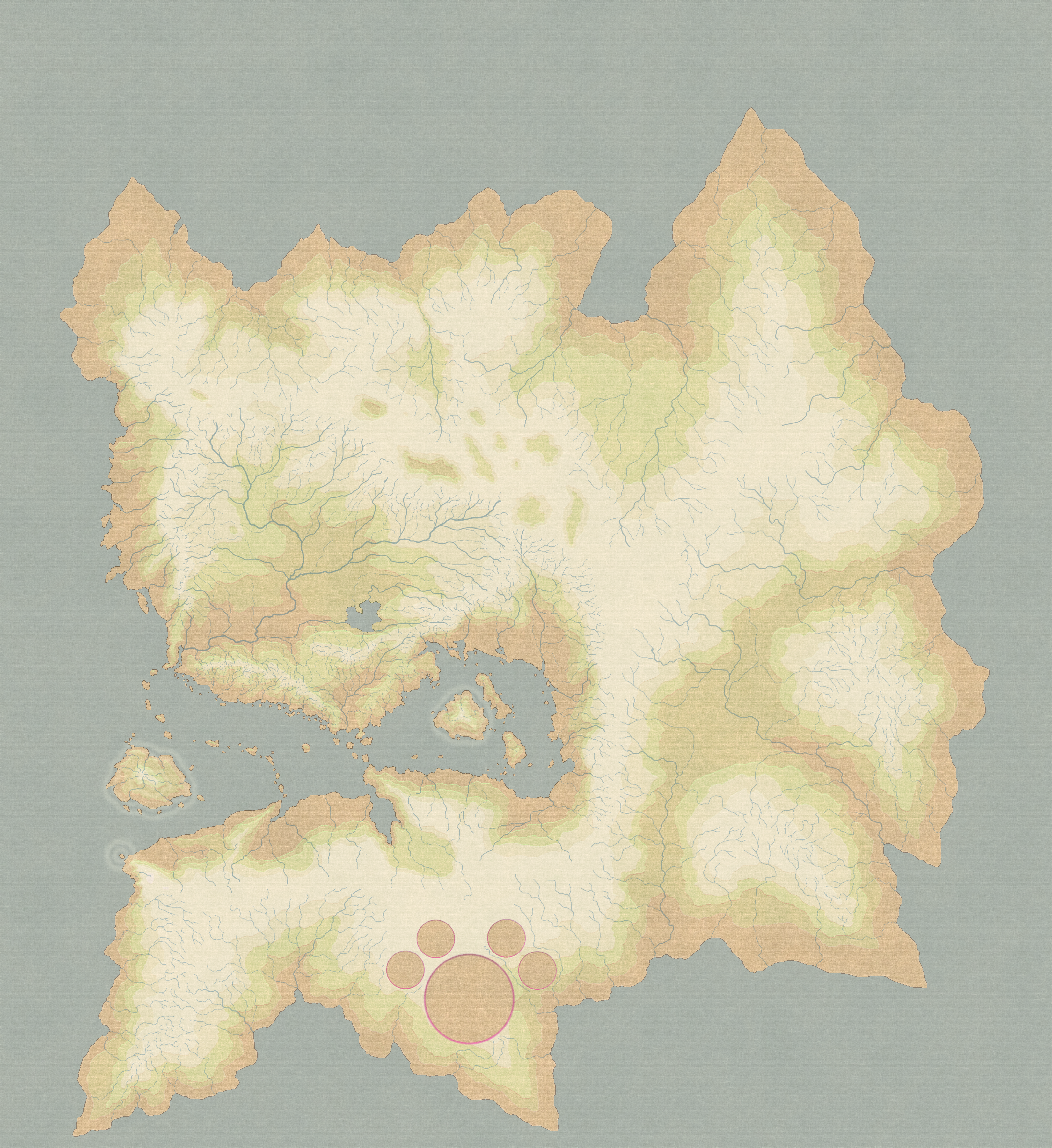
Here's is a blank version of a new map I am developing. I'm looking for some feed back with the aim of improving the map.
EDIT: For some reason my map won't upload, so here's a link to the picture on Deviant Art:
The Link
Last edited by elemental_elf; 01-14-2011 at 01:21 AM.
This is looking really good. I don't see any problems with the rivers (!! I am not a riverologist !!). What is the scale? Is this a big island, a continent? What are those circles?


Looks good to me. I like the color palette and your watersheds look good. I too am intrigued by the circles and the all-important scaleWhat software are you using for this one?
Gidde's just zis girl, you know?
My finished maps | My deviantART gallery
My tutorials: Textured forests in GIMP, Hand-Drawn Mapping for the Artistically Challenged
Looks very good.
I am the breath of Dragons...The Song of Mountains...The Stories of Rivers....The Heart of Cities.... I am A Cartographer....
Finished Maps
Kingdom Of Shendenflar Campaign Setting (WIP)

Everything I post is free for use and redistribution under the Creative Commons Attribution-Noncommercial-Share Alike 3.0 licence, except where noted otherwise in the thread.


Colors are great and the rivers are my fave part here (except the thick parts should probably taper off instead of ending abruptly). Not sure why some of the islands have white rings and the others don't. So far so sweet.
If the radiance of a thousand suns was to burst at once into the sky, that would be like the splendor of the Mighty One...I am become Death, the Shatterer of worlds.
-J. Robert Oppenheimer (father of the atom bomb) alluding to The Bhagavad Gita (Chapter 11, Verse 32)
My Maps ~ My Brushes ~ My Tutorials ~ My Challenge Maps
Thank you all for posting, I really appreciate each and every post!
Thank you!Originally Posted by Naeddyr

I don't have the scale quite figured out but the "continent" is roughly a million square miles. So not huge but still fairly large.
Thank you!
The circles demarcate areas where Archmagi levitated whole mountain ranges to form their own personal floating islands (which are not pictured in the map). The spells used were of epic proportion and their after-effects (including what can be described as a lighter gravity, which allows the flora and fauna in the areas to grow to substantially larger than any where else on the continent) linger. Actually the only reason I included the circles was to let the viewer know that the 5 big (for a lack of a better term) "crop circles" on the map was indeed intentional.
EDIT: I am using CS3 to create this map.
Thank you very much!
My next goal is to make the larger rivers taper off and form deltas
The islands with the white rings represent islands that are mingled between the other planes and the material plane. Basically, they're islands where the inland portions are much, much larger than their shorelines (as seen from the outside) appear to be.
Last edited by elemental_elf; 01-16-2011 at 02:27 PM.
Ok so I updated the map, adding in more lakes and making most of the rivers taper off. I tried a few different ways to taper the rivers off including more delta-like and wider endings, so let me know if you like either/or.

Last edited by elemental_elf; 01-18-2011 at 08:16 PM.
Sidenote, I would really, really suggest that you switch from .png to .jpg at this point. You are using a paperizing texture, and there are no more areas of uniform colour, so there is nothing to lose if you post a slightly lossy .jpg instead of a 16 meg .png online.
I suppose you're right
I edited the previous post, putting in a JPEG.
Last edited by elemental_elf; 01-18-2011 at 08:17 PM.
 Posting Permissions