Page 1 of 2 12 LastLast
Results 1 to 10 of 13

Thread: Ask for help - town mapping

  1. #1
    Guild Applicant
    Join Date
    Apr 2011
    Location
    Poland
    Posts
    3

    Help Ask for help - town mapping

    Hello,
    that is my first post on this forum so I would like to welcome. OK. Now I can to come straight to the point: I want ask to advice about my (village) city map. My object is small, polish village, which I have to place on the map. Only this village. But, it is elongated, thus the neighbouring villages "push in" my map. What can I do with it? I use GIMP.
    And I sorry for my not-perfect English - I am poles, and English is not my native language.
    Sketch of map in attachment (I've underlined my object on red)
    Attached Thumbnails Attached Thumbnails Click image for larger version. 

Name:	mapaznow.png 
Views:	77 
Size:	312.9 KB 
ID:	34991  

  2. #2
    Community Leader mearrin69's Avatar
    Join Date
    Sep 2009
    Location
    Portland, OR
    Posts
    2,318

    Default

    Welcome to the Guild! Your English is very good for a non-native speaker (better than my Polish!) but I don't quite understand your question. The village you want to draw will fit within the red bordered region? And nearby villages come right up to the edges of it in the southwest and northeast?

    If you're saying that you don't want to show those villages, only the one you're focusing on, you might try drawing everything and then "fuzzing" the areas beyond your village out...like a camera view that shows a flower clearly but the background is blurry. Photoshop has a tool called Gaussian Blur which would do this for you (using selections and perhaps the feather option) but there are other plug-ins you could use. I don't know about GIMP but I think it will have something similar.

    If I've misunderstood your problem please try to clarify if you can. Hope that helped!
    M

  3. #3
    Guild Master Facebook Connected jtougas's Avatar
    Join Date
    Sep 2010
    Location
    Wales Massachusetts
    Posts
    2,813
    Blog Entries
    27

    Default

    GIMP does have this ability as well. Another thing you could do (and forgive me if this sounds too simplistic) is to just show the area in red. Scale the map in a way that only the village you wish to show is visible.
    I am the breath of Dragons...The Song of Mountains...The Stories of Rivers....The Heart of Cities.... I am A Cartographer....

    Finished Maps
    Kingdom Of Shendenflar Campaign Setting (WIP)

    Everything I post is free for use and redistribution under the Creative Commons Attribution-Noncommercial-Share Alike 3.0 licence, except where noted otherwise in the thread.

  4. #4
    Community Leader Facebook Connected Ascension's Avatar
    Join Date
    Jun 2008
    Location
    St. Charles, Missouri, United States
    Posts
    8,392

    Default

    If I understand this correctly, the top right and lower left have villages encroaching on the village in the middle. I would put building very close together in the top right and lower left and in the middle. Then around that put less densely clustered buildings. On the outskirts put fields. A city wall might also help to define the central part of the village.
    Attached Thumbnails Attached Thumbnails Click image for larger version. 

Name:	screenie.jpg 
Views:	120 
Size:	1.43 MB 
ID:	34995  
    If the radiance of a thousand suns was to burst at once into the sky, that would be like the splendor of the Mighty One...I am become Death, the Shatterer of worlds.
    -J. Robert Oppenheimer (father of the atom bomb) alluding to The Bhagavad Gita (Chapter 11, Verse 32)


    My Maps ~ My Brushes ~ My Tutorials ~ My Challenge Maps

  5. #5
    Community Leader mearrin69's Avatar
    Join Date
    Sep 2009
    Location
    Portland, OR
    Posts
    2,318

    Default

    Nicely illustrated. That's a pretty good looking map for a quick hack!
    M

  6. #6
    Guild Applicant
    Join Date
    Apr 2011
    Location
    Poland
    Posts
    3

    Default

    Alright, let's see:
    1) I just want to hide other villages
    2) @mearrin69: if I correct understand you, I should install Photoshop (of course trial version) and use tool Gaussian Blur. And that should help me, yea?
    3) @jtougas: imo that is impossible. I can't scale only main village, without other.
    4) @Ascension: Good job! but I also need show the most important buldings, like orthodox church, museum or Communal Center of Culture, so some bulding must to distinguish.

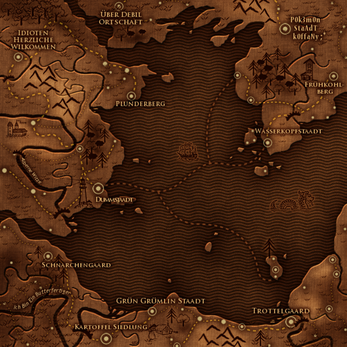
    I thought to do the map in this style, but now I think so that is not good choose

    Maybe some one of you have any better ideas?
    and thanks for help!

  7. #7
    Guild Journeyer Aelyn's Avatar
    Join Date
    Jan 2010
    Location
    Somewhere in Europe
    Posts
    118

    Default

    I have a question which is completely off-topic: Is there a reason that most of your villages have insulting names?
    Now that the warm fuzzy part is over we can get back to the ritual dismemberments. Oh wait, it's not Tuesday is it?

  8. #8
    Guild Journeyer Ryan K's Avatar
    Join Date
    May 2009
    Location
    Brisbane, QLD
    Posts
    221

    Default

    I'm not certain that is his map.
    Regards,

    RK

  9. #9
    Community Leader Facebook Connected Ascension's Avatar
    Join Date
    Jun 2008
    Location
    St. Charles, Missouri, United States
    Posts
    8,392

    Default

    He just wants to do it in that style - I wish I could read German now because I'm itching to know what the words say. The style is possible but you need to draw it all out by hand (which will take some time) so you better get started. Instead of using the little buildings to represent the whole town make each building represent one building - you are going to need a lot more of varying shape. I understand your desire to represent other buildings, my little black squares are just to represent placement, not the final drawing. Draw about 10 different houses and then draw the important buildings that you want and then place them down and make copies of them and place them down - and so on.
    If the radiance of a thousand suns was to burst at once into the sky, that would be like the splendor of the Mighty One...I am become Death, the Shatterer of worlds.
    -J. Robert Oppenheimer (father of the atom bomb) alluding to The Bhagavad Gita (Chapter 11, Verse 32)


    My Maps ~ My Brushes ~ My Tutorials ~ My Challenge Maps

  10. #10
    Guild Journeyer Aelyn's Avatar
    Join Date
    Jan 2010
    Location
    Somewhere in Europe
    Posts
    118

    Default

    Quote Originally Posted by Ascension View Post
    He just wants to do it in that style - I wish I could read German now because I'm itching to know what the words say.
    Since I have to practice for my upcoming translation exam, you're lucky. This is what it reads:

    Über Debil Ortschaft - Over Moronic Village
    Idioten Herzlich Willkommen - Idiots Most Welcome
    Plunderberg - Junk Mountain
    Frühkohlberg - Early Cabbage Mountain
    Wasserkopfstaadt - Hydrocephalus City
    Dummstaadt - Stupid City
    Schnarchengaard - Snore Garden
    Trottelgard - Dumbass Garden
    Kartoffel Siedlung - Potatoe Settlement

    and the two rivers:

    Alberne Witze - Foolish Jokes
    Ich bin ein Butterfertiger - no real sentence, the word butterfertiger doesn't exist

    Maybe now you understand why looking at the map made me very puzzled.
    Now that the warm fuzzy part is over we can get back to the ritual dismemberments. Oh wait, it's not Tuesday is it?

Page 1 of 2 12 LastLast

Posting Permissions

  • You may not post new threads
  • You may not post replies
  • You may not post attachments
  • You may not edit your posts
  •