Page 2 of 3 FirstFirst 123 LastLast
Results 11 to 20 of 22

Thread: 3D Atlas of Barsaive [Earthdawn] using Unreal3/UDK

  1. #11
    Administrator Redrobes's Avatar
    Join Date
    Dec 2007
    Location
    England
    Posts
    7,196
    Blog Entries
    8

    Default

    Is this all done using the Unreal Dev Kit then ? Not having used it, I was wondering what was creating the water flow in these shots since I am interested in these kinds of things.

  2. #12
    Guild Apprentice Telarus's Avatar
    Join Date
    Jul 2008
    Location
    Oregon
    Posts
    31

    Default

    Hi guys! I'm swamped with IRL at the moment, but I appreciate the comments/questions. Thanks a lot!

    Redrobes,

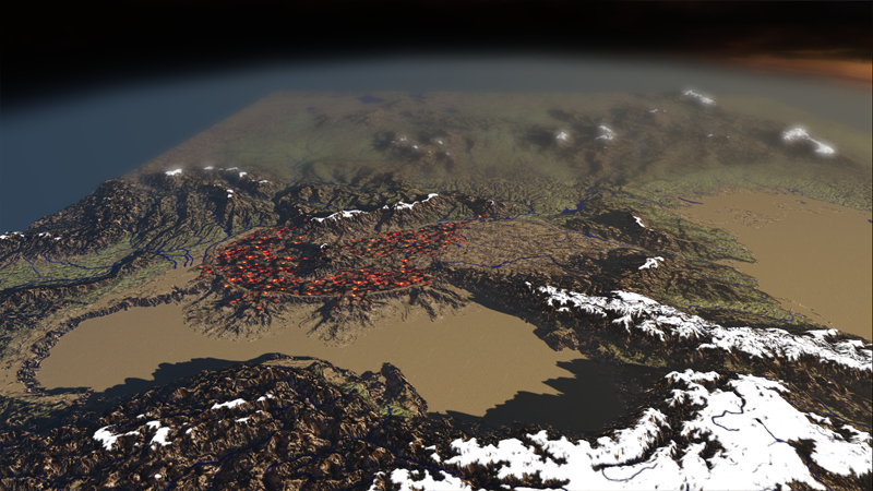
    I'll tackle the water question in brief. The UDK/Unreal3 material editor allows you to have targa images define pretty much any component of your surface (so, in this example, I used a hand edited copy of some free DEM river-valley-registration of the IRL area). I used this "river map" not only as a mask to paint the Blue diffuse color onto my diffuse texture, but also in a separate node-network to define ONLY where I want the surface highlights to show up. These highlights are animated by some simple noise maps, and some rotation nodes further up in the network (which otherwise would cover the entire landscape). At this point, I do want a few independent water surfaces, but only for the Seas. The rivers are painted right onto the landscape. I do have to note that the vector river data, and my DEM source didn't match up 100% so I do have some streams flowing "uphill" when it cuts a corner faster then the DEM heightfield does.

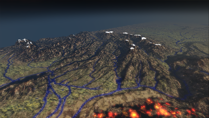
    Tools used: This was not done "only" in UDK. I have extensively used Photoshop and L3DT (bundysoft.com), along with some work in the student version of Mudbox. Most of the visual detail was added with L3DT, and I'm currently using that program to generate a more complex "texture splatting", a set of alpha maps that tell the engine where to paint, say grass vs rock vs mud vs sand. It is also not to IRL vertical scale, and has been "ResBumped" (a custom version of the workflow I developed from ideas @ shadedrelief.com), and as mentioned had 8 major mountain ranges edited into the DEM data.

  3. #13
    Guild Apprentice Telarus's Avatar
    Join Date
    Jul 2008
    Location
    Oregon
    Posts
    31

    Default

    Oh, RedRobes! I saw in another post that you're part of the ME-DEM team. I owe you guys a few :1-up:s, man. I read nearly every discussion blog on your site a few years back and it really helped with this project, because it had all been lurking in the back of my head while I researched this project.

    +rep

  4. #14
    Administrator Redrobes's Avatar
    Join Date
    Dec 2007
    Location
    England
    Posts
    7,196
    Blog Entries
    8

    Default

    Cheers, At Medem we have a pretty complicated workflow too and I am only aware of half of it since Monks gives me the final height map as a starting point for the texturing and shading. Everyone finds water and rivers difficult. We have rivers like Anduin which have to be positioned correct for the Tolkien world so its not arbitrary. Although we have to get the mountains and terrain sort of correct to get Anduin in the right place we are still putting that river down by hand in a similar way to what you are doing. I have my GeoTerSys app which will calculate some water flows but its not a quick process and were now using a 40x40 tile set so it takes too long. That app does generate a lot of terrain masks calculated from the inputs plus the sim and were using that to generate the texture types like what your doing with your splat masks. Once we have all the masks then it goes into the programmable shader which maps textures to masks in varying blending amounts to produce the final colour map, we have the light map and shadow map produced from GTS earlier. For the viewing, were investigating this so its useful to look at Unreal. We have looked at Proland - a research app from a chap in France and were also doing a lot of talking with the dev of Outerra and he has been integrating the height maps only into that. In the longer term we would like to see some more colour control and snow in MeDem + Outerra but its very early days.

    I used to have a copy of L3DT and we used to chat to Aaron a fair bit. When I tried it out, the terrain viewer was 3D but of limited size and I know he was working on a new one which he must have finished a long time back now. We decided not to go with L3DT mainly because it was well geared up for generating a lot of terrain but not so good for generating a lot of specific placed terrain like an existing Tolkien map that people would stare hard at and criticize for correctness.

    These new breed of real time terrain viewers are awesome but are on limited availability. Using Unreal would be a good call for making a game and getting something up and running when you don't have these new ones. Unreal is probably better optimized for running on an existing gaming platform like a PS3 or XBox which are now a few generations of graphics capability behind the state of the art. But look at Proland on you tube and the Outerra forums and just keep them in the back of your mind going forwards.

  5. #15
    Guild Apprentice Telarus's Avatar
    Join Date
    Jul 2008
    Location
    Oregon
    Posts
    31

    Default

    Thanks for the info, I'll look into that. Here's some recent work.

    Some Shots with the final textures (although I do need to tweak them for brightness issues and maybe paint in more Lava). Lookin pretty good.


  6. #16
    Guild Apprentice Telarus's Avatar
    Join Date
    Jul 2008
    Location
    Oregon
    Posts
    31

    Default

    So all my materials broke, and then I had to fix them, and now I have to build my lighting for a few hours again. Here are some shots with test lighting.

    Final Textures and Materials (normals corrected and parallax mapping/bump-offset on all materials except snow).

    Full Map View:


    Lake Ban & Throalic Mts (right), Servos jungle and Tylong Mts (left):


    Death's Sea & Twilight Peaks


    Cara Fahd / Landis / Vivane / Sky Point (foreground), Delaris Mts, Liaj Jungle (background):


    Liaj Jungle (foreground left), Tylon Mts, (midground), Throal Mts (background), Twighlight Peaks (right)


  7. #17
    Guild Apprentice Telarus's Avatar
    Join Date
    Jul 2008
    Location
    Oregon
    Posts
    31

    Default

    Added some water surfaces, and the lighting came out nicely. Took a hit on the frames-per-second at high altitudes tho.... I may have to do some streaming tricks if that slows things down later.


  8. #18

    Default

    This is freakin amazing- great job Telarus

  9. #19
    Guild Apprentice Facebook Connected razcor's Avatar
    Join Date
    Sep 2009
    Posts
    46

    Default

    Really impressive!

  10. #20
    Guild Adept loogie's Avatar
    Join Date
    Mar 2008
    Location
    Strathroy, ON
    Posts
    371

    Default

    Looks great man, quite amazing, and a world you can actually explore... just great.

    As for the river issues you and redrobes have been having, I'd assume this is something you guys have done (since its seems a pretty basic thing, at least when I world with DEM's and rivers in real life, but have you every played around with "Burning in" the rivers? basically, if you have a vector representation of your rivers, you can "burn" them into your DEM, basically makes the heightmap blacker, thus lowering the height where the vector.. obviously that would cause greater problems if your vectors are too far off your DEM, but if its fairly similar you should be able to sort of override the DEM riverbeds with the vector burns with a bit of tweaking.. we usually do this with every DEM we get, tho most of the time our vectors and DEM's come from the same source, in our case it's usually just to define them more...

    I Also had an amazing open sourced program that did a lot of Hydrology raster analysation using DEM's which may allow you to build your own river vectors from your DEM... i'll search around for the name, for some reason i think i actually posted it here a few years back.. it was open sourced, and allowed you to build watersheds which basically define where the water will flow in any given point on the map, this allows you to figure out where rivers would go, most of the time to a greater detail than you would ever want.. unfortunately it won't help for rivers that don't follow traditional rules, and i've found pieced together or modified DEMs usually cause all kinds of problems unless they are done really well, but i would think your DEM would get some great results...
    Photoshop, CC3, ArcGIS, Bryce, Illustrator, Maptool

Page 2 of 3 FirstFirst 123 LastLast

Posting Permissions

  • You may not post new threads
  • You may not post replies
  • You may not post attachments
  • You may not edit your posts
  •