

 Reply With Quote
Superb! Thank you so much for sharing that with us!

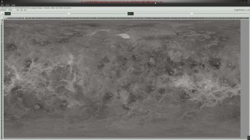
if you still need a topographic map i recently ( in February ) completed a massive 12 gig ( 131072 x 65536 Px. ) RGB image of the SAR radar
and a 4 gig 16 bit topo Height map( 65536x 32768 Px.) reworking the SAR data to get the height data from it
if people want i can resize it down
some links to images OF it
the C-1 compressed Magellan SAR DATA ( destripped )
http://www.imagebam.com/gallery/f3bc...72twzupqy07sj/
the Topo Height data

http://www.imagebam.com/gallery/gd89...06292pigyou39/
rendered Venus Height data
http://www.imagebam.com/gallery/tv28...jwc99c254uzl1/
Superb! Thank you so much for sharing that with us!
Bryan Ray, visual effects artist
http://www.bryanray.name


Very cool - how is this licensed?
Visit my Worldbuilding Blog or follow me on Twitter!
http://pds.nasa.gov/citation/index.shtmlhow is this licensed?
the standard NASA license
but i tag on CC-BY-SA
right now i only have texture add on for Celestia published
but a 16384x8192 or 8192x4096 Px. image can easily be put on a torrent
Well, thanks a lot,
I'm thinking to improve my venus map as I did for mars, so... It's a good start for doing it I guess!
here is a link to a 16384x8192 8bit gray image of the SAR
http://www2.zshare.ma/z64e3f6ly9xr
-- this map --- 50.4 Mb ,16kVenus.zip
0 deg long is in the center
90 north to 90 south
-180 west to 180 east
Last edited by johnvanvliet; 09-03-2012 at 04:26 AM.
Well, I changed my mind a little bit...
My Elzevir world is an uchronia with a different technology progression than our history line, but it's current date is 1948, and I think the NASA picture is far too detailed than possible in this context. So, I found another base from USGS based on altitude lines.
Here are the results for the "normal" and the political maps.
Thanks again for the support !
Hey that's really cool! Nicely done.
Cheers,
-Arsheesh
Thanks a lot Arsheesh !
It was a long term work.

Hey johnvanvliet,Originally Posted by johnvanvliet

Thanks so much for your work on building the SAR radar and topo maps. I realize this thread hasn't been visited in quite a few years but I was just curious to see if you still had those maps in their largest resolution available? The reason why I ask is I'm working on an animation involving a spacecraft being sent through the Venetian atmosphere and touching down in the Alpha Regio area and could definitely use maps of decent resolution for creating the landscape. While the topo map is most appealing to me, I am definitely interested in both if it's possible to have them hosted somewhere. I believe I saw at least the topo one parceled out on the Celestia Motherlode but as much as I use maps in my own animations, I don't have a ton of experience stringing together or compiling the tiles that are being hosted on the site. I often just work with the large cylindrical maps within our 3D programs.
If you could, lemme know if you do happen to have those large Venus maps available. Thanks!
Brian
 Posting Permissions


