

 Reply With Quote
I really like the parchment. Are you going to make it in hand-drawn style? Are you talking about the placement of geographical features (mountains, rivers, forests etc.) or about the style?


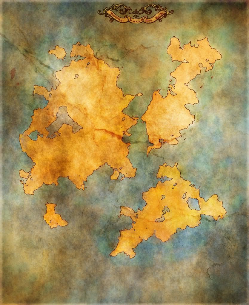
Hey, This is a world map i'm making for my DND Campaign . I'm kinda stuck because I whenever i place anything on it , it doesnt look right . Right now i'm thinking I need to make a height map so i can figure out where to place everything . I'm using someone else's continents that I got off of DA( im pretty sure its CC) so I dont have any of control over lakes .I hadn't used GIMP before or taken a real stab at map-making so the continents were pretty helpful . Anyway, any suggestions?

I really like the parchment. Are you going to make it in hand-drawn style? Are you talking about the placement of geographical features (mountains, rivers, forests etc.) or about the style?


If a work on dA is CC, it will explicitly say so. If not, you are asking for trouble as they can get REALLY temperamental over there. I'd be careful even if you do see a CC license as a lot of "deviants" don't have a clue what CC even means and turn it on simply because it's there. You also need to be aware of the particular terms of any given CC license. For instance, right now you are not attributing it, which is a requirement for any CC license except CC-0. "Someone else on DeviantArt" is not sufficient attribution.
IANAL
I really recommend doing your own continents, because it's just going to mean so much more to you. A simple way that I personally enjoy is just pencil on paper, then clean up the scan on a computer, auto-trace it ... and from there you have a bundle of tutorials on this site if you want to make the continents more random and such.
@ Gan Thanks, I'd like to do it hand drawn, but i might end up using something like those hand-drawn brushes simply because my wacom is on the fritz, I was talking about the placement of the geographical features
@Hai-Etlik oh what i meant by im pretty sure its CC is they said , feel free to use it for whatever attribute me or not, but i would like to see what you make with it,and i just wasnt sure if that was still considered CC or just "Free" . But thank you for the caution , its true that a lot of people dont have a good understanding of creative commons (myself included).
@Lukc, yeh thats what i was doing initially but i'm still trying to figure out the scanner . I also started making some continents out of the render->noise filter on GIMP because yeh, putting a bunch of time and effort into it I -would- like it to be my world .
I meant that if it is Creative Commons, you are required to attribute them. You need to say who you got this from. Whether there are any requirements for you to license it to others depends on the particular license, as there are several different Creative Commons licenses. You need to be clear on the specific terms of the license.Originally Posted by BlueMoon

There we go, took a bit of looking but i found it, ironically enough, found it through the cartographers guild group on DA
Continent outlines made by :
http://calthyechild.deviantart.com/#/d49xu2j
(btw, beyond all the legal nonsense, i would attribute whoever did the work just because its ethical, i just figured since it was a WiP i didn't need to have all that together ,but i'm new to all this so i figure you would know much better then i do)
oh, and although im probably going to re-make the continents , does anyone have any tips as far as making an elevation/height map?
Last edited by BlueMoon; 10-31-2011 at 12:04 PM.
It's important as soon as you try to distribute it. Posting it on a public website certainly counts, whether or not you consider the work finished.
Building a decent DEM from scratch is a lot of work. Unless you are planning to do a map with some form of detailed relief symbolization (Contours, hillshading, etc), you don't really need it.
My advice would be to plot out ridges, starting with mountains, and then working down to significant hills, or just shallow rises that extend over large areas. Then place your rivers accordingly. You don't need a complete surface, just the idea that rivers generally flow away from ridges. (With a few exceptions where they are surrounded and must go through one ridge or another, usually resulting in a lake or a canyon.)
Also continents tend to have mountains along their edges, not as spines running along their middles.
Thanks for the heads up, also thank you for your opinion on the DEM I had already sort of started on one and ended up feeling so frustrated that I've kinda dropped the map altogether for the momet, i'll post whatever i get accomplished up here whenever i get the chance, for the moment I think i'm gonna work on some dungeon maps .
 Posting Permissions

