Results 1 to 10 of 21

Thread: Using DEM data for fictional maps?

Hybrid View

Previous Post Previous Post   Next Post Next Post
  1. #1
    Guild Journeyer
    Join Date
    Jul 2008
    Location
    Toronto, Canada
    Posts
    195

    Question Using DEM data for fictional maps?

    Hi

    I've had a look around, but can't really find anything concerning this.

    After finding this tutorial for creating relief shading using elevation data collected of the earth or known as DEM (Digital Elevation Map), I wanted to get some of that grey scale data to cut and paste into my own fictional maps.

    Photoshop's Difference Clouds can only go so far and though you can get away with something passable to the common eye, I think it's just not cutting it really for something realistic...


    So my next step is to use DEMs and cut and paste real world 'bits' on to my fictional map before rendering out the relief. I have found some things on the web and in the process of trying to achieve my goal, but it's a lot of fumbling about.

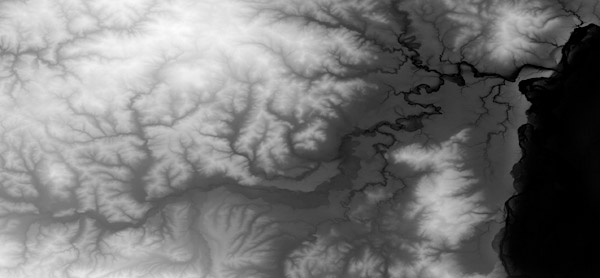
    After these kind of things...

    (image taken from the tutorial mentioned at the start)

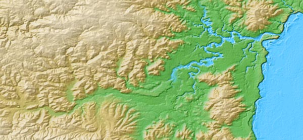
    ...to make the relief on my maps to be more realisitc...


    (image taken from the tutorial mentioned at the start)

    Does anyone know if a stash of free, donwnloadable, decent resolution, grey scale height maps of mountains, valleys, flatland , etc? in a TIFF or PS friendly format? Or gone through what I'm trying to do themselves?

    I have tried the USCG seamless data distribution online application but cant see anything in their viewer (even though I've followed their screen res instructions)

    I've also tried Bryce, but it's height maps don't come out very defined in photoshop. I'll keep at it.

    thanks for looking and any help you might have.

    Jez

  2. #2
    Administrator Redrobes's Avatar
    Join Date
    Dec 2007
    Location
    England
    Posts
    7,196
    Blog Entries
    8

    Post

    Hi Jez,

    Theres a few of us into 3D terrain mapping and we write a few apps to help. Firstly there is a member here called 'Waldronate' who is also JoeS who writes Wilbur and I believe this app can convert USGS topo data into height field format. The download and tutorial for that is here.

    http://www.ridgecrest.ca.us/~jslayton/tutorials.pdf

    He has a CG tutorial with more on that here too.

    http://www.cartographersguild.com/showthread.php?t=1160

    I also write a 3D terrain viewer called DragonFlight3D. There are some static examples on RPGMapShare which were done off of the USGS topo database here...

    http://rpgmapshare.com/index.php?q=gallery&g2_itemId=99

    and more recently were all involved in the Cartographers Guild Cooperative Map Building Project which has its own thread forum. Anyway, much of that is done in 3D and so there are some data sets for the DragonFlight Viewer here also.

    http://www.cartographersguild.com/sh...10&postcount=6

    Theres a few of us here that are members of the Middle Earth DEM group for which myself and Seer are admins and the main site for that is www.me-dem.org on there are some workflow documents describing how to draw maps in 3D and convert data sets and lots more. So they are worth a look too.

    'Anna' is another member doing Greyhawk using Bryce and 'Patrakis' has recently said he is doing Forgotten Realms Toril in 3D also.

    I would hit the index under 3D & the award section for Wilbur tutorials and see what else you find.

    http://www.viewing.ltd.uk/Temp/CG/In...word_Index.htm

    Edit --
    Should also mention that I make a simple 3D terrain creator which outputs height maps too. You can find that here :-

    http://www.viewing.ltd.uk/cgi-bin/vi...nstant_islands

    and Waldronate writes Fractal Terrains for which there are lots of tutorials on here too.

    http://www.profantasy.com/products/ft.asp

    There is also libnoise / terranoise

    http://www.cartographersguild.com/showthread.php?t=1422

    and terragen also which is geared up to creating and rendering photo real images of synthetic terrain.
    Last edited by Redrobes; 07-13-2008 at 10:40 AM.

  3. #3
    Community Leader Facebook Connected Ascension's Avatar
    Join Date
    Jun 2008
    Location
    St. Charles, Missouri, United States
    Posts
    8,392

    Post

    I don't know if it's of any help or not but instead of chopping up bits n pieces and pasting em all together I just brush in my elevations to emulate the dem look. Simple white strokes with a blur do the trick although recently I've been experimenting with dodge and burn. It's time consuming but it gives more control of the final product.

  4. #4
    Guild Adept SeerBlue's Avatar
    Join Date
    Jan 2008
    Location
    Black hills of South Dakota
    Posts
    257

    Post

    here is an excellant site for free dem data, GIS Data Depot, you have to register, but it is free.
    With free membership you can down load dems from each states county wide coverage, 10 and 30 or 90 meter coverage, depending on the area.
    So you click on the state of interest to you, on the next page click county wide coverage, next page the county, and finally the locale you want.....so you kinda have to know what you want. If there is more than one resolution for the dem both are listed. The site also has alot of other mapping associated formats besides dem. Googling dem, download, srtm, should give a good list of sites, some of which will be free.
    SeerBlue
    SeerBlue is me, but more importantly the Four Happy Carpet Orcs +2 (FHCO +2) are Lizzy (BumbleMouse, 16), Race (Raith Eliathy, 11), Roy (Ol' Horsehair, 9), and Lena Marie (Lemur, 6) Kimi (Whurm,2), and Sachiko (MoMo,1)
    All creative inspiration is theirs, from characters to maps to tells, I only fill in the details.

  5. #5
    Guild Journeyer
    Join Date
    Jul 2008
    Location
    Toronto, Canada
    Posts
    195

    Post

    Hi there. Thank you for your posts.

    Redrobes : a lot of information there. Thanks for taking the time to put all that up! I'll explore those various options. I do like the rendered terragen cut away like that - I think Bryce can do the same thing?

    Ascension: Yeah I had thought of that, but didn't try it because I didnt think I could get the intricate fractal like branch veins that are so distinctive on the DEM there. Do you have any examples? I'll like to see how it turned out for you.

    SeerBlue: Yeah I found that site. I think I missed the registration bit. Probably why that when I explored the site it seemed to be showing fees no matter if I looked in country or not. I'll register and try again. That might be just what I'm looking for - thanks for the google tip too.

    thanks for your help
    Jez

  6. #6
    Administrator Redrobes's Avatar
    Join Date
    Dec 2007
    Location
    England
    Posts
    7,196
    Blog Entries
    8

    Post

    Quote Originally Posted by jezelf View Post
    I do like the rendered terragen cut away like that
    That was my DragonsFlight3D - thats a free and quick way to get that image. Just take the images from your post, pad them up with black so that they are square, save as Color.bmp and Height.bmp and put in same directory as app and run it.

    http://www.viewing.ltd.uk/cgi-bin/vi...dragons_flight

  7. #7
    Guild Journeyer
    Join Date
    Jul 2008
    Location
    Toronto, Canada
    Posts
    195

    Post

    OK! This is the results of having 'fun with Wilbur' . There could be a lot more improvement, I feel I've only just scratched the surface, but it improved my map no end by adding the erosion that su_liam pointed out. I'll probably still study some DEMs ( nature is a good teacher ) and see what other details can be next.

    Thanks guys! - and the fun with Wilbur tutorial helped me get straight to what I wanted to do (thanks Waldronate) . I'll be exploring the other aps mentioned. Also need to try out Fun with Wilbur Pt 2!


    cheers!
    jez

  8. #8
    Community Leader Facebook Connected Ascension's Avatar
    Join Date
    Jun 2008
    Location
    St. Charles, Missouri, United States
    Posts
    8,392

    Post

    Wow, that's pretty nice.

  9. #9
    Guild Artisan su_liam's Avatar
    Join Date
    Aug 2007
    Location
    Port Alberta, Regina(IRL: Eugene, OR)
    Posts
    798

    Default

    <pant><pant>That's so hot!

    Yeah, I know, but my wife would hurt me if I looked at the other kind of porn...

    Honestly, it's frakkin cool what you could do with just Wilbur.

  10. #10
    Guild Journeyer
    Join Date
    Jul 2008
    Location
    Toronto, Canada
    Posts
    195

    Default

    Thank folks. It 's for a tutorial to show various relief methods in Photoshop and use of Wilbur.

Posting Permissions

  • You may not post new threads
  • You may not post replies
  • You may not post attachments
  • You may not edit your posts
  •