Page 1 of 3 123 LastLast
Results 1 to 10 of 22

Thread: WIP: Thränjök, an earth-like planet

  1. #1
    Guild Novice Polkadot's Avatar
    Join Date
    Nov 2015
    Location
    Dallas
    Posts
    14

    Wip WIP: Thränjök, an earth-like planet

    Hello!

    This is my very first map and would love to get some feedback on what I have so far.

    World name: Thränjök

    I decided to start building this word based on an idea for a novel. Originally I was going to just draw a rough map, but then I realised I wanted the climate zones to be accurate which meant doing more than just the main continent and down the rabbit hole I went. I based the original continent shapes based on coffee stains I made on printer paper. I scanned them in and went on the do the tectonic plates, currents, winds, elevation, rains, temperatures, and now I'm working on the climates.

    This project has been a mix of pen and paper (and coffee), GIMP with a mouse on my work computer (lots of free time as a receptionist), and Photoshop with a tablet at home. The initial bits up through the rain portion were done almost completely in GIMP, but now I'm mainly working on it at home so I can use PS and my tablet.

    This first map shows what I used as my initial elevation reference. Once the climates are finished, an atlas-style map will be next on the roster. After that, I would like to work on an illustrated version of the whole map as well as larger-scale illustrated versions of certain areas.

    Click image for larger version. 

Name:	Thranjok.jpg 
Views:	248 
Size:	2.99 MB 
ID:	77198

    I do not have any rivers marked yet as I wanted to refine the topography before placing them. (also just realised a few of the lakes/seas on the eastern continent need to be moved/erased)

    Maps showing the tectonics, currents, winds, etc. can be posted once I get home if anyone wants to see those.

    Feedback is greatly appreciated!!
    Last edited by Polkadot; 11-03-2015 at 04:14 PM.

  2. #2

    Default

    Hi and welcome to the Guild!

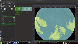
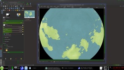
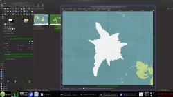
    Looking at the scale of the map, I noticed it is a full-world map. And I happen to have this brand new toy program (found here) that can project maps onto a planet. The Orthographic (space-view) projection shows that the land near the north pole seems unnaturally stretched out, forming very long islands.
    Though that is perfectly plausible (it IS an imaginary world after all), it looks a bit weird to me.
    The south pole on the other hand looks perfect!

    I've taken the liberty of making the height map more obvious (applying PS's Levels) and noticed a very peculiar style.
    I can only describe it as the wrinkles of a skin. It looks very awesome! How did you do that?

    As for the additional map information (tectonics, winds, currents etc), I think I can speak for everyone here that we're all very, very interested in seeing how you did them.

    A great start and I can't wait to see more!

  3. #3
    Guild Novice Polkadot's Avatar
    Join Date
    Nov 2015
    Location
    Dallas
    Posts
    14

    Default

    You know, I feel silly now. I used the G.Projector to fix the south pole, but didn't even look at the north! It looked so nice in the equirectangular view, I didn't even think about it. It does look quite weird on the globe. Well, I'll go in after work and try to round those islands out and fix them up. Thank you for pointing that out!!

    The weird texture is mainly just a side effect of the method I used to make the mountains. I used the render>clouds / lighting effect method to make the elevation map and it looks like the wrinkles are from using the soft brush before using the lighting effect. It does look really odd close up!

    Once I get home, I will fix the various maps to match the new islands and then I'll get them on here.

    Thank you, Shikotei!

  4. #4
    Guild Novice Polkadot's Avatar
    Join Date
    Nov 2015
    Location
    Dallas
    Posts
    14

    Default

    Alrighty. So I haven't had the chance to fix the northern islands yet, but here is the tectonics map (which should remain largely/wholly unchanged by the island situation):

    Click image for larger version. 

Name:	Thranjok - tectonics.jpg 
Views:	88 
Size:	1.52 MB 
ID:	77202

    Of course now that I'm posting it I see more issues than before. For instance a few arrows don't quite work and I'm thinking that the convergent bits on the Western side of the map might be a bit much...

    Would love to know what others think.

  5. #5
    Guild Expert johnvanvliet's Avatar
    Join Date
    Jul 2012
    Location
    N 42.39 W 83.44
    Posts
    1,091
    Blog Entries
    4

    Default

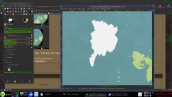
    the PROBLEM with g-project is it can not reproject a polarstereographic image back into simple cylindrical

    Gimp has a BUILT IN TOOL - no extra plug in needed
    Filters > distorts > polar coordinates
    that can remap the poles
    then fix the poles
    then remap back


    --4k remapped after cleaning up the poles


    i like using the built in " heal " tool and the "resynthesizer" plugin
    --resynthesizer-- on git
    https://github.com/bootchk/resynthesizer
    ( will build in MinGW on windows )
    Last edited by johnvanvliet; 11-04-2015 at 01:11 AM.
    --- 90 seconds to Midnight ---
    --------

    --- Penguin power!!! ---


  6. #6
    Guild Novice Polkadot's Avatar
    Join Date
    Nov 2015
    Location
    Dallas
    Posts
    14

    Default

    Wow, I had no idea that feature was there. That is awesome and will make my life so much easier when I try to fix those islands (and fix up the south pole more while I'm at it). The ones you did look so great!

    You're a hero, johnvanvliet.

  7. #7
    Guild Expert johnvanvliet's Avatar
    Join Date
    Jul 2012
    Location
    N 42.39 W 83.44
    Posts
    1,091
    Blog Entries
    4

    Default

    you will find that you will get the best results by

    cutting the top or bottom half of the image ( 8192 x 4096 to 8192 x 1024 )
    resizing it back to a 2 to 1
    remapping to polar

    fixing it

    remapping back "from polar"
    resizing back to 2 X 0.5

    and if you use a bit of a overlap -- i use about 100 pixels
    crop a 8192 x 4096 to 8192 x 1124

    that way i can blend edge of the image back in to the original
    --- 90 seconds to Midnight ---
    --------

    --- Penguin power!!! ---


  8. #8
    Guild Novice Polkadot's Avatar
    Join Date
    Nov 2015
    Location
    Dallas
    Posts
    14

    Default

    Alrighty. So instead of going any sort of simple route to fix the continents, I ended up starting from scratch. The messed up shapes were a good excuse to redo the lines and make the whole thing cleaner. Here is the new version!!

    Click image for larger version. 

Name:	Thränjök- modified.jpg 
Views:	80 
Size:	996.9 KB 
ID:	77250

    In addition to changing the shapes of the northern parts and the south pole, I did some eroding on the two outer continents to get shapes I liked better, though I'm still not sure about the eastern one... Next up will be a new height map and then redoing all the climate stuff.

    Would love to get some feedback before I start all of that again.
    Last edited by Polkadot; 11-06-2015 at 11:19 AM.

  9. #9

    Default

    Wooow you've done so much work till now and you've just restated the whole thing, i admire you !! I love the long groups of islands
    Go on, it will be great !

  10. #10

    Default

    I like the look and the "feel" of the map! It's very well done! However, I feel like the south eastern islands are somewhat... illogical; I've never seen two parallel island chains like that, next to each other. Perhaps someone with more geological experience want to comment on this phenomenon? It will be interesting to see your tectonic plate map of this world latter on =)

Page 1 of 3 123 LastLast

Posting Permissions

  • You may not post new threads
  • You may not post replies
  • You may not post attachments
  • You may not edit your posts
  •