Wow, that's big.


After issuing a challenge to @Diamond, I was smacked with the challenge below. No progress yet, but posting it here is the first step...
1. Eons ago, mankind settled the red planet, Mars. One of the earliest settled areas was the great Valles Marineris, Mariner's Valley. This massive chasm, almost as wide west to east as the continental United States, was a hotbed of mineral wealth and an ideal location for early sea formation.
2. The terraforming went on for centuries and was eventually successful. Mankind and his genetically engineered servant races spread to the four corners of Mars. But... nothing lasts forever. Eventually, contact with Earth was lost. Nuclear annihilation? Plague? Rogue AI's? No one knows. The civilizations of Mars went on, alone. And then one day, the terraforming began to break down.
3. Let's see a map of a post-Earth Mars, thousands of years from now. Specifically, the Valles Marineris region.
4. At one point this was a huge inland sea emptying into the Great Northern Ocean. There are still some minor lakes and rivers at the canyon's bottom, but for the most part everything has dried up.
5. During the first years and decades of colonization/terraforming, people built on the surface, on the newly fertile lands around the canyon's edges, with mines here and there to extract mineral wealth, but as time went on and the water level began to sink, folks started building lower and lower in the canyon to stay close to the water. They built towns on spires of rock sticking out of the water. They carved cities from the walls of the canyons. Eventually they populated the chasm's floor.
6. Your challenge is to map, in as much detail as you want, the various major (and minor, if you want to) civilizations that have existed through out the canyon's history.
7. You could do a basic top-down view and 'layer on' the various civs that existed in the same area(s) over the centuries, or maybe do a side view to show the sequentially lower and lower settlements. Totally up to you.
8. Don't forget the engineered races that Man brought with him or created on Mars; I'm sure they've got their own proud histories by now...
9. Make sure to include some ancient artifacts and ruins, etc.
10. Sidebars with brief histories are totally optional.
_*_*_*_*_*_*_*_*_*_*_*_*_*_*_*_*_*_*_*_*_*_*_
Open to cartographic commissions. Contact me: christian [at] stiehl.net
christianstiehl.com


I had to get him back somehow.Originally Posted by Chashio

I'm actually panicking a little bit over the one he gave me...
Isn't it great? That little shot of adrenalin you get when you semi freak out about how are you going to do this? LOL
When its over and you look in the mirror, did you do the best that you were capable of? If so, the score does not matter. But if you find that you did your best you were capable of, you will find it to your liking. -John Wooden
* Rivengard * My Finished Maps * My Challenge Maps * My deviantArt
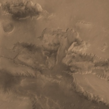
Who knew the Valles Marineris had so many awesome named locations?! I mean, 'Noctis Labyrinthus"--how sweet is that?
I dove into Wikipedia and grabbed some photos. Started doing research. I loaded up Google Earth and switched to "Mars Mode", enabling me to look at the valley from lots of angles.
I'm planning a layered approach, with semi-opaque overlays of zoomed in areas. The valley itself is crazy huge: the part shown below (which is most of it) would stretch across the entire continental U.S.
Keeping in mind @Diamond's terraformed-but-also-post-apocalyptic specifications, I'm planning to make the surface areas mostly sandy and reddish (it just won't feel like Mars if it's not somewhat rosy) and make the valley floor and cliff sides full of terraformed vegetation. There will be great dam-like walls at the far low end (on the right) to keep the water, humidity, and thick air trapped in the canyon. The rest of Mars, beyond the canyon cliff-tops, is slowly reverting to its inhospitable state as the influence of the ancient terraforming continues to wane.
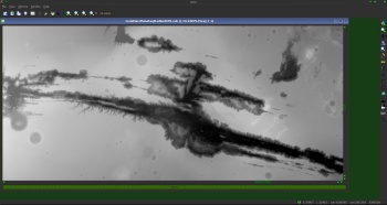
Here I am doing some hand-trace work to give myself a clean outline for the tops of the canyon walls:
### Latest WIP ###

_*_*_*_*_*_*_*_*_*_*_*_*_*_*_*_*_*_*_*_*_*_*_
Open to cartographic commissions. Contact me: christian [at] stiehl.net
christianstiehl.com
the 128 pixel per degree MOLA gridded data is here
PDS Geosciences Node Data and Services: MGS MOLA MEGDRs
128
pds-geosciences.wustl.edu - /mgs/mgs-m-mola-5-megdr-l3-v1/mgsl_300x/meg128/
if someone needs the current DEM
currently stereo CTX imaging is being done to improve the DEM
the "Mars Orbital Laser Altimeter" ( mola) quit working early in the mission
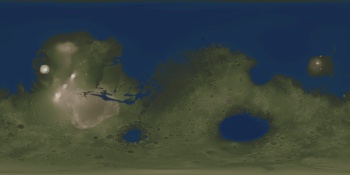
and this is the correct color for this area on mars
( from my Mars map )
as for terraformed
a global unlabeled map
--- 2048x1024 reduction of the 8192x4096 map ---
Last edited by johnvanvliet; 11-18-2014 at 09:00 PM.
@johnvanvliet - Wow, that's super nice of you to send all of those resources my way. I'll be sure to put them to good use as I continue working on this project!
_*_*_*_*_*_*_*_*_*_*_*_*_*_*_*_*_*_*_*_*_*_*_
Open to cartographic commissions. Contact me: christian [at] stiehl.net
christianstiehl.com
Here I am, sketching out the plans for all the call-outs and zoom-ups that will appear on the map. I'm going to try to use discipline and do a decent job on all of them, rather than getting lost in doing a great job on one or two and running the risk of not finishing the map. The fun part is (aside from basic, wild creativity) being able to do a bunch of different styles of map all in one. I actually had a thought early on that I could draw a multi-layer interface, like they had in Avatar or something, with the zoom-up regions "floating" above the landscape like holograms... but that might be too ambitious. We'll see about doing that after I get most of the art work done.
The notes are written in cursive and mostly for my benefit, so if you can't read them, you'll just have to wait a few days for more map to show up. ;-)
### Latest WIP ###

_*_*_*_*_*_*_*_*_*_*_*_*_*_*_*_*_*_*_*_*_*_*_
Open to cartographic commissions. Contact me: christian [at] stiehl.net
christianstiehl.com
That's going to look very impressive, I think, with all of the larger-scale insets and the city map.Very much looking forward to what styles you choose to blend into the whole. The "multi-layer interface" sounds painfully ambitious for the available time, but very cool.
If not now, it'd be all sorts of awesome to see in the future.
I agree with Chashio, I'm both curious of how you'll deal with it and eager to see it finished
 Posting Permissions