

 Reply With Quote


Has this request been taken?


Hello artists and cartographers,
So I'm starting a total conversion project for Paradox's Crusader Kings 2 game and need help with creating both a heightmap (greyscale indexed bmp format) and a colormap (dds format) of Square Enix's Final Fantasy X Spira world.
Original in game world view
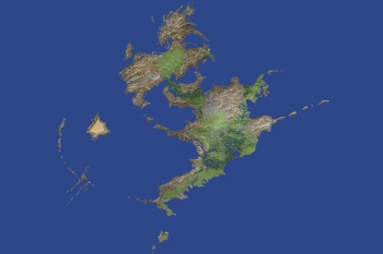
Present outline
The game uses several different map files to create the map in game, but topology and color maps are really too hard for me to properly do. The maps should be resized to 4608*3072 pixels (proportions should be kept, landmass centered) on the surface. Sea level for the heightmap is at 94 (0 low - 255 high). (Rivers and lakes appearing on the second attached map, should be below sea level.)
It'd be awesome if one of you pros or passionates could help me around with this. I've been trying some tricks I read about the forum and all, but wether I'm understanding things wrong or just too bad at it, I don't know. Either way, I can't manage to make it look good. Anyway, you'll receive full credit for the map and my deepest gratitude, of course! (By the way, if you could please join a black and white outline of your map for me to readjust the other map files or use the one I provide, it'd be great. Thanks!)
And, finally, thanks for your help, people!
Last edited by Pyrrha; 10-28-2014 at 09:41 PM.
Has this request been taken?
It hasn't yet. Sorry for the answer's delay.
i can produce a heightmap using "Shape from shade" from the second image in the first post
-- i would need time to edit it first to remove the lettering and such
-- it looks like it would work "ok" , not perfect but fine
now i work in 32 bit float , but can convert it to almost any format
and a 8 bit heightmap WILL look stepped
( think of the stepped pyramid in Egypt )
8 bit images only have 256 tones of gray
16 bit heightmaps have 65538 tones of gray
being unpaid , this is a spare time project
--- 90 seconds to Midnight ---
--------
--- Penguin power!!! ---
that makes almost NO sense(Rivers and lakes appearing on the second attached map, should be below sea level.)
a few lakes in a VERY low area might be a bit below sealevel
but rivers can NEVER!!!! be below sealevel
they would flow BACKWARDS and UP HILL
--- 90 seconds to Midnight ---
--------
--- Penguin power!!! ---
Sea level is 94
-- should be 0

Last edited by johnvanvliet; 05-27-2015 at 01:34 AM.
--- 90 seconds to Midnight ---
--------
--- Penguin power!!! ---
Of course, I understand. And, believe me, I am very grateful for your help! Every little bit helps.Originally Posted by johnvanvliet

I do realize it doesn't, however, this being a map meant to be introduced in a strategy game (as a total conversion mod), I have to keep the major rivers at sea level in order to make them navigable (due to game engine limitations).
At any rate, I do thank you for your help. The colormap (if I work out warmer color contrasts) is just fine. The heightmap will need a bit of reworking for it to actually simulate properly in game, but it definitely gives me a good head start on it.
As promised, you will be credited if I eventually manage to release the mod. Is there a specific name you'd like me to use in the credits, though?
And again, thank you for your help. It does make a difference.
Last edited by Pyrrha; 05-29-2015 at 10:15 PM.
 Posting Permissions