Reply With Quote


Has this request been taken?


Hi everyone
Idk if i can ask a grayscale height map, but i'll try
Project Scope:
A map for a city which will be built in a Sims Create a World tool. It is second attempt, first one abandoned on 92% rate after constructing skyscrapers in city center which made whole map look flat (my bad)
This city will be uploaded for players, and will be free of charge.
Tech Description of Map:
Map have actual size: 2048x2048 (it have other sizes, but i need the largest one)
Grayscale 16 bit (program restriction)
Mountains on both side of the map is "distant terrain" restriction.
Idea
A city placed on two parts of land, divided by a bay (which have actual width size, restricted by bridge).
"A" part - small and hilly, hills continue to grow and become mountains (the end of map on one side), 1\3 of whole map, i suppose. Rural\Community houses will be placed here, also need some kind of plains for farm\estate houses. Would be great to have the observation hill (with flat cape), from which could be whole city viewed.
"B" part - 2\3 of whole map, more flat areas, microbays, harbor (this one should be like totally flat and drawn in rough straight\45* lines), a place for a beach would be awesome (if it will be long it will be totally nice) the city itself should stand above the shore, so it will match the height of the "a" part, the outskirts of the second part should also be hilly and become mountains.
The style of the city is mix-match of urban Tokyo and historical Kyoto. So the B part is urban (maybe terraced city?), A part is historical. Also it would be great to have one special island standing in the bay for the replica of "hot-bath" seen in "SEN TO CHIHIRO NO KAMIKAKUSHI", due to the building restriction island should have a flat top 64x64 size.
Time
Idk how long it takes to create an idea, than converse it to actual grayscale map, so no strict limit, but maybe before new year
Copyright
Artist have all the rights, me have a right to use it in my city, and upload for free on one major sims 3 fan site, artist will be mentioned of course. Actually: on this.
Some pictures
pic1 - actually base idea
pic2 - really nice beach smoothing
Thanks in advance! Really hope anyone could give it a try ^_^
P.S.
nebovcvetochek (at) gmail (dot) com
Last edited by happyyasu09; 11-02-2014 at 09:55 PM. Reason: added contact
Has this request been taken?
This request has not been taken, you could try) all the sizes are in pixels)
Hi Happyyasu09, thanks for letting me know. The reason I asked was because I am retiring old commission requests to the archives. I'll keep this one active in that case.Originally Posted by happyyasu09

Cheers,
-Arsheesh
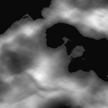
i was already working on a rather large image
cropped out a 2048x2048 area near the equator , added a "sealevel"
-- took about 10 Min.
how is this 8 bit normalized copy of the 32 bit floating point ( values are 0 to 65535 )
( part of Venus, real data of the second planet )
i can add in rivers if you like it
Last edited by johnvanvliet; 01-17-2015 at 12:05 AM.
--- 90 seconds to Midnight ---
--------
--- Penguin power!!! ---
It's actually nice looking) though I like Venus maps since simcity4) I'm at work rnow, so I'll check it in CAW when I get home) But thanks!
This is AWESOME! Actually )
Two maybe's:
1) Mountains a bit higher than now (only mountains, so the center area would still be the same level)
2) A little bit more somewhat flat area in the center (maybe move down\left mountains to the border?)
Overall It's not necesary for mountains to be fully on the map, half of them could be (to show they are there), and a half of them will be actually covered by "no camera\routing layer" so splitting 'em would be more efficent, so i could have more space for city itself) Also more flat area is a somewhat program restriction, TGA patterns are very hard to lay over very jagged terrain. (((( *cry* (((
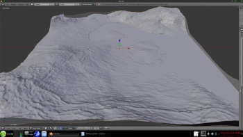
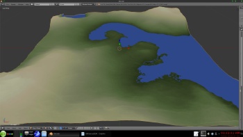
some tinkering
a two 3d screen shots very basic rendering
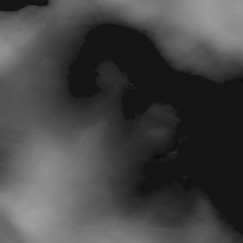
a 8bit preview of the 16 bit tiff in the zip file
-- the preview is 1/2 scale
a zip of the 5.5 meg 16 bit tiff file
https://drive.google.com/file/d/0B6Z...ew?usp=sharing
in about a week i will pull the file down
--- 90 seconds to Midnight ---
--------
--- Penguin power!!! ---
This is awesome, thank you! Could you please pm me you profile page if exists, so I could place it in info of my project?
 Posting Permissions