

 Reply With Quote

Wow, a very cool project and a great start!


Hi All.
This is going to be my first map, and my first time documenting my work through this forum.
I thought I would dip my toe in fantasy cartography by trying to capture the 'on surface' movements of NASA astronauts Armstrong and Aldrin over the 22.5 hours they were on the luna surface.
Hopefully there will be enough elements contained within the poster to test some cartographic devices and play with scale and various information types. Im really looking forward to seeing how this turns out as Ive always been a fan of space exploration and technology.
I have made a rough schematic of the poster - A3 proportion - so could scale to A2 if information density is getting too great.
I will work through the various elements as time permits.
At the moment i am trying to bed down a visual style for the map - Modern, period (~1970s), or something left field. My inital thoughts are towards a 70s graphic approach with a modernist twist within the diagrams / typography - well see.
Has anyone else had a crack at illustrating moon terrain?
C & Cs welcome.
Cheers Tom.

Wow, a very cool project and a great start!
Hi all.
Managed to squeeze in a few hours to push the concept a little further over the New Years Holliday. Developed a first pass at the crater treatment. I think it is a little too photograpic at the moment and is lacking a bit of illustrative style.
My reference, or benchmark were some 19th Century luna renderings by Étienne Léopold Trouvelot. Ill have to get hold of a tablet I think to give me better control of the line work. Ill continue to work on this and push a few more treatments around. I might try a totally line based approach - although Ill have to work our a way to render the different types of crater edge. Hmm .
Im happy the way the colour pallet is heading although its quite monotone and brown at the moment. This will change, and be fleshed out over time.
I think I will develop the treatment of the diagrammatic elements and have a go at visualising the 22 hours of surface operations as a timeline along the bottom next.
Ill also work on the map boarder (frame?) elements as well
C & Cs welcome.
Cheers Tom
Crater Detail
Reference - Moon - 1875

as in ink / pen drawing , noillustrating moon terrain
just using real imaging data and the LRO stereo DEM height data
up until recently most "moon" photos were photos of cast & carved plaster done in a studio
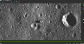
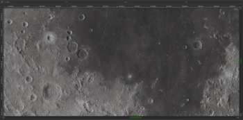
a shot from LRO, you can see the SHADOW of the lower half of the lander
http://airandspace.si.edu/webimages/..._carousel1.jpg
http://www.nasa.gov/sites/default/fi...ollo11_lrg.jpg
and the scientific data
http://wms.lroc.asu.edu/lroc/view_rd...OI_APOLLO11LOA
info and download info
http://wms.lroc.asu.edu/lroc/view_rd...1LOA_E004N0235
Last edited by johnvanvliet; 01-03-2015 at 06:06 PM.
--- 90 seconds to Midnight ---
--------
--- Penguin power!!! ---
instead of adding
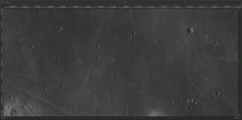
a set of images OF the Apollo 11 landing stage on the moon
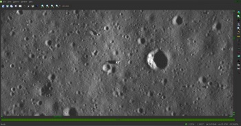
---- from the LRO Narrow angle camera
0.5 Meters per pixel resolution
( zooming out from the lander )
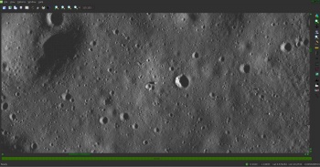

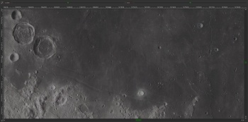
and a zoom out of the same area with a mosaic from the LRO wide angle camera
6 Km per pixel resolution

--- 90 seconds to Midnight ---
--------
--- Penguin power!!! ---
@ johnvanvliet
Great set of links - love the scaling images - I still have trouble grasping the scale of things - staggering to think they can get 0.5px / meter resolution. The lander site images you have linked to will definitely be of use.
I had suspected the some of the earlier (60's - 70's) maps were illustrated then photographed.
Cheers Tom
I work with this kind of data all the time
it is possible to get access to EVERY image taken by EVERY NASA spacecraft ( and some "ESA" and "JAXA -Japan" )
and even some other imaging data
like the 6x7 cm images from cameras the Apollo Astronauts had strapped to themselves
--- 90 seconds to Midnight ---
--------
--- Penguin power!!! ---
Hi All.
After messing around with a few different map treatments and a bit of head scratching, I felt myself starting to go around in circles. Knowing this could go on forever I decided to step back and take a fresh look at my mapping problem.
Aim
To visually represent the 21.5 hours 2 astronauts spent on the surface of the moon.
This would show:
- Site terrain
- Physical elements - Lander position, American flag, various science instruments etc
- Site position of images taken while on the surface
- Pathways and activity areas used by the astronauts
This would all be tied together by means of a timeline illustration the sequence of events
The problem.
My landing map is too photographic (i.e. very similar visually to my site reference material) and does not have the visual clarity required - it will overpower the other map elements when combined
The issues at hand
Area
Land area represented is approximately 70m x 120m - quite small
Geographic topology
There is alot of same. No immediate distinctions such as water, land, vegetation, mountains etc to give visual structure.
Ive made a short list ordered by geographic subtlety of what would likely appear on the ground around the landing site.
- Shallow depression
- Very subdued crater
- Subdued crater
- Sharp crater
- Rocks
If I match appropriate visual elements and treatments to each type I should get a good starting point to the underlying structure of the map.
Physical Items
- Lander position
- American flag
- LRRR - Laser Ranging Retroreflector
- PSEP - Passive Seismic Experiment Package
- SWC - Solar-Wind Composition
- TV - Television camera
- ALSCC - Apollo Lunar Surface Closeup Camera
- Jettison Bag
These are known things with a size, shape and location.
Temporal Activities
- First Steps
- Panoramic Photography
- Science experiments / observations
- Moon Walks
These would be mapped over / on the base topology.
Lets See how this goes.
Cheers
Tom
Missing the mark - Alternate Crater Treatments

Hi All.
A quick update to progress. In my last post I outlined a course of attack.
I made a short list ordered by geographic subtlety of what would likely appear on the ground around the landing site. Shallow depression, Very subdued crater, Subdued crater, Sharp crater, Rocks. These were mapped onto a base area.
Primary Elements
Detail
Roughing in colour, texture and tone as per Shallow depression, subdued crater,
Sharp crater, Rocks etc...
Detail
I felt the overall tonal quality was a bit uniform, so I tweaked the Contrast and Hue (via adjustment layers within PS) of the ground layers - This resulted in an appropriate amount of visual 'noise' a gives a nice level of visual diversity. Because I used adjustment layers I can go back and tweak this if need be.
Detail
Now to add the detail as per this list:
Physical Items - known things with a size, shape and location
Lander position, American flag
LRRR, PSEP, SWC, Television camera, ALSCC, Jettison Bag etc...
Temporal Activities
First Steps, Panoramic Photography, Science experiments / observations, Moon Walks
Still working on the detail, colours etc...
I am comfortable with the overall look and structure and will now move onto the frame and border elements. Will no doubt continue to tinker with small details.
C & C welcome.
Cheers Tom

