Reply With Quote
This is full of awesomeness! The sea (and its lots of details) is just a beauty (and the work on frame aswell) I can understand it took you a long time to do

It's been a while... =)
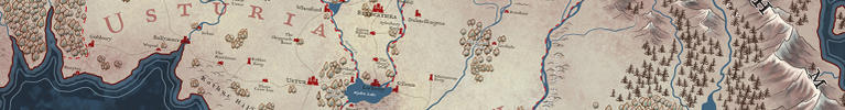
I am so proud I’m finally able to show this since it was featured during RPC 2015 in Cologne! It was A LOT of work, but it was worth it. Together with the map of Markus Holzum (check him out) this is a depiction of the continent Aventurien. While he had a more realistic approach I aimed for a more ingame-looking one. Let me explain:
The map was fictitiously ‚made‘ by a sophisticated cartographer who tried to capture the real shape of the continent he is living on. He did this by collecting all maps he could find and arranging them, re-measuring them and completing it. This means:
- The map is a little bit changed based on the ideology of his faith, how it should look like and what makes sense to him. This is especially visible if you look at the shape of specific areas or the arrangement of mountains.
- Not all parts are completely correct in terms of having the correct north. This means single areas of a tiny map he used as a reference could have been not completely pointing north.
- Since the people on this continent are measuring from a fictive point in the south, the whole continent tends to be broader overall in the north due to measuring reasons of a sphere.
- The referenced maps he used hadn’t all the same measurement. This means, the measurements he corrected tend to be a little bit wrong. Since it is not easy to measure exactly everywhere, the coasts difficult to ship tend to be bigger (since the poeple sailing there took longer). Vice versa, good roads tend to shorten the area travelled since it is went faster. In relation to each other this means that some areas are not the correct size.
- Cultures which are heavy into nautical business tend to have more precise coastlines.
- The origins of the cultures the painter knew of are indicated on the map, too. He used assumptions to paint that in.
- The painter used icons he found on the original maps he used. This means he found specific types of ships on individual maps and used this in his version, too. Leading to things like a hand on the discus near ‚Maraskan‘ (sign of the dual faith), the ‚Uthurische Rose‘ in the south, ‚Eissegler‘ in the north, etc. You can find A LOT of that stuff in there ;)
- Finally, he drew the border. In this he included every culture he knew of roughly on the height of the culture on the continent if you would draw an invisible line to the middle of the map. Honeycones of the ‚Norbarden‘ in the northeast, Shadif-horses in the southeast, the ‚Praiosmal‘ (sun) in the south, the printing press in the west near the ‚Horasreich‘, the northern lights on the nortwest, elvish archery equipment, the swan of Ifirn, the Madamal (moon) with the most important cycles, etc. There is so much more, try to find out ;)
Feel free to ask questions. This is the map I’m most proud of yet and I hope to get the chance to do something like this again. Even though it was hard work I really had fun with this. Also, it would be a shame not to share my thoughts on the map here, too =)
Soon I'll show another kind of made like this. Sadly I'm not allowed to show this larger, but the original file is about poster size.
Feel free to rate or rep if you see fit =)
This is also on my Deviantart-Account.
Made with Wacom Intuos 4, Photoshop 6, a lot of research and coffee.
Stay creative everyone! (c) Ulisses Spiele & Distribution GmbH, 2015
Edit (July 13th 2016): And here is a Making-Of... =)
Use this link: Here you go!
Attachment 85209
Last edited by SteffenBrand; 07-13-2016 at 05:35 AM.
Visit me on ArtStation.
This is full of awesomeness! The sea (and its lots of details) is just a beauty (and the work on frame aswell) I can understand it took you a long time to do
Wow, there's an incredible amount of work went into this and it's a shame we can't see a larger size to really zoom into the detail. But what a fantastic job!!
Edit: Can't rep you unfortunately
"We are the music makers, and we are the dreamers of dreams"
Thanks so much you two =) If my informations are correct, there will be posters of this in the future.
I'll be sure to link it when they are available. I can understand the publisher in this regard.
However, at least this size is fine. It would be a shame not to share with you awesome guys, even though this isn't my usual B/W-stuff.
Visit me on ArtStation.
Brilliant artwork! I can see why you are so proud of it! Colors are great and the level of detail is mind-numbing


What a beautiful map!
I'm glad to finally be able to see this one. It's spectacular Steffen.
There's lots of interesting stuff in that border and the Sea.... THE SEA! That looks wonderful.
Well worth the effort. Look out - rep incoming.
Artstation - | - Buy Me a Kofi
Map looks amazing. So detail, much wow.
Would love to see it in a higher resolution. Methinks the sea looks a bit busy at such small scale. Would def look much awesomer if big. I also really dig the idea of "separating" the compass rose in N/S/O/W, that's real original, that is.
It's a beautiful map. And if I hadn't recently given you rep, you'd have it for this one again.
Love the sea. To be honest though, I can't read a single name on it.
 Posting Permissions