Reply With Quote
Wouldn't Morikahn's suggestion mean you get a lot of distortion when making a regional map? Looking at a regional map of Europe you notice it's often a bit different from Europe on a world map, no?


I would love to see a tutorial on MMPS, even more so for ISIS3, with which I have no experience.Originally Posted by johnvanvliet

One obvious advantage of MMPS, at least, is that you could work with projections. With Wilbur, you'd be working strictly with latlong or blowing up a patch of a predetermined coordinate system. Re projection would have to be done separately, and many of the simpler apps for reprojecting maps assume a full globe equirectangular image. Problematic, that.
Last edited by su_liam; 07-23-2015 at 12:02 PM.
Astrographer - My blog.
Klarr
-How to Fit a Map to a Globe
-Regina, Jewel of the Spinward Main(uvmapping to apply icosahedral projection worldmaps to 3d globes)
-Building a Ridge Heightmap in PS
-Faking Morphological Dilate and Contract with PS
-Editing Noise Into Terrain the Burpwallow Way
-Wilbur is Waldronate's. I'm just a fan.

Wouldn't Morikahn's suggestion mean you get a lot of distortion when making a regional map? Looking at a regional map of Europe you notice it's often a bit different from Europe on a world map, no?
yes there would .
but the map in the first post is not really map projected
it looks to be some what in a almost Mercator projection ( almost)
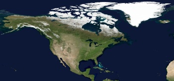
using the Earth is a good example -- people know what it looks like
three different projections for the SAME bit of land - North America ( i live in Michigan )
85 North to 10 North
-170 West to -10 West
all 3 are at 16 pixels per degree
-- Simple Cylindrical --
-- Mercator --
-- Polar Stereographic --
for some reason i have noticed a LOT of squarish maps that are not in Mercator but look to be almost but not quite in Simple Cylindrical ,but some cross in between .
Last edited by johnvanvliet; 07-22-2015 at 03:26 PM.
--- 90 seconds to Midnight ---
--------
--- Penguin power!!! ---
Great information here. Glad I joined. I have one question on the world map sizing and making smaller detailed maps. I am planning to use Ascension's tutorial which has a square canvas. Would a rectangle canvas better represent the oblate ellipsoid that Earth is when creating our own fantasy world? Will I cause more problems using G.Project or other tools?
It is better to use an equirectangulatr map (aka platte carré) at a 2 for 1 ration. Most softwares use this as their default projection so you can project it to another projection later.
My Deviantart: https://vincent--l.deviantart.com/
Great information. I tried the 1:1.6182 Golden Ration approach, but I see I put too much though into it.
the 2 x 1 comes from there being 360 degrees Longitude ( east / west ) and 180 degrees latitude ( north / south )
also computers are "binary " they REALLY like things in multiples of two
( 2,4,8,16,32,64,128,256,512,1024,2048,4096,8192,163 14,32768,65535,....)
so most software works best if the image is also a "multiple of two"
( NOT a stead fast rule( most of the time) but just a good idea to use -- IF possible )
i tend to make images that are
4096x2048 px
8192x4096 px
16384x8192 px
or HUGE ( 131072 x 65536 px )
--- 90 seconds to Midnight ---
--------
--- Penguin power!!! ---
 Posting Permissions