Page 1 of 2 12 LastLast
Results 1 to 10 of 18

Thread: WIP- My Homebrew Setting Map

Hybrid View

Previous Post Previous Post   Next Post Next Post
  1. #1
    Guild Member heathan666's Avatar
    Join Date
    Oct 2008
    Location
    Does Hell actually have an address???
    Posts
    89

    Post WIP- My Homebrew Setting Map

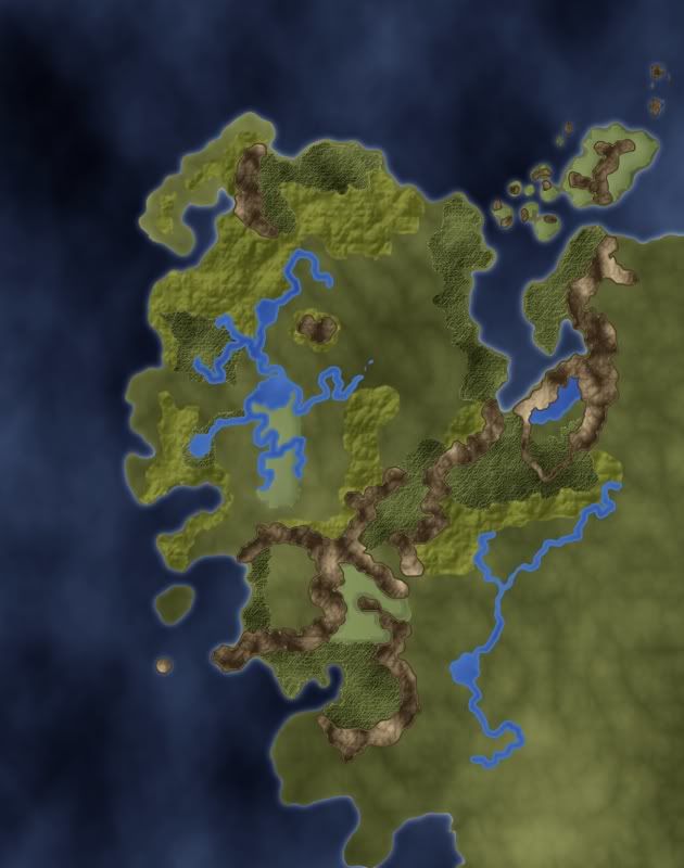
    I actually started workin' on this like way back when. But after reading a tutorial on her, I came out with this, I still have a few pieces to add, like the desert & badlands, as well as the artic wastes to the south. Tell me what you guys think.
    I know I might go back and change the rivers and such I really don't like how they came out. If this was really scaled those rivers would be like 2 miles wide in most places.


  2. #2
    Community Leader Gandwarf's Avatar
    Join Date
    Jun 2008
    Location
    Netherlands
    Posts
    3,012

    Post

    I think it looks nice enough, very colorful. But you are right about the rivers. Also, the light green stuff is forest? It looks like the rivers were put in after the forests, which makes for a weird effect (the rivers are on top of the forest). What's that small round island in the west?
    Check out my City Designer 3 tutorials. See my fantasy (city) maps in this thread.

    Gandwarf has fallen into shadow...

  3. #3
    Guild Artisan Facebook Connected
    Join Date
    May 2008
    Location
    Atlanta, Georgia, United States
    Posts
    928

    Post

    The concern with the rivers is that they don't go anywhere, the way this map looks. Of course, rivers empty into the sea, but here they don't appear to.

    It also doesn't look like the start anywhere (rivers are fed primarily by snow-melt and rain runoff from mountains and possibly from springs and other sources like that).

    Finally, rivers merge together from feeder streams, typically not branching until they reach the sea.

    From the map here, I can possibly guess that the rivers are emptying into a couple lakes, but I can't see any reasoning why the lake then doesn't feed something that empties into the ocean.

    Otherwise, it's a good start working in GIMP on this style of map (I style I am slowly trying to work through myself).
    I think, therefore I am a nerd.
    Cogito, ergo sum nerdem.

    Check out my blog: "The Undiscovered Author"
    It's the story of a writer... follow me in my simple quest to get published, and share your own writing stories, adventures and writerly tips.

    Pimping my worldmap here. Still WIP... long way to go, but I'm pretty proud of what I've done so far...

  4. #4
    Community Leader jfrazierjr's Avatar
    Join Date
    Oct 2007
    Location
    Apex, NC USA
    Posts
    3,057

    Post

    Quote Originally Posted by Karro View Post
    The concern with the rivers is that they don't go anywhere, the way this map looks. Of course, rivers empty into the sea, but here they don't appear to.

    It also doesn't look like the start anywhere (rivers are fed primarily by snow-melt and rain runoff from mountains and possibly from springs and other sources like that).

    Finally, rivers merge together from feeder streams, typically not branching until they reach the sea.

    From the map here, I can possibly guess that the rivers are emptying into a couple lakes, but I can't see any reasoning why the lake then doesn't feed something that empties into the ocean.

    Otherwise, it's a good start working in GIMP on this style of map (I style I am slowly trying to work through myself).
    What Karro said. Also, I would say that you have to much texture on various parts of the map, making the whole thing look a little busy. Of course, this may just be because this is a WIP and you have not finished it yet, so let's see some more and perhaps you already have some ideas of making this look a little more natural.
    My Finished Maps
    Works in Progress(or abandoned tests)
    My Tutorials:
    Explanation of Layer Masks in GIMP
    How to create ISO Mountains in GIMP/PS using the Smudge tool
    ----------------------------------------------------------
    Unless otherwise stated by me in the post, all work is licensed under a Creative Commons Attribution-Noncommercial 3.0 United States License.

  5. #5
    Guild Member heathan666's Avatar
    Join Date
    Oct 2008
    Location
    Does Hell actually have an address???
    Posts
    89

    Post

    well I wish I knew how to blend it all together better, but the "rough looking green areas" are supposed to signify hill country, whil the more flatter dull green areas are actually swamp lands (yes I know I failed in my attempt to capture see level murky doom). But when I redid the rivers earlier it came out great.

  6. #6
    Community Leader jfrazierjr's Avatar
    Join Date
    Oct 2007
    Location
    Apex, NC USA
    Posts
    3,057

    Post

    Quote Originally Posted by heathan666 View Post
    well I wish I knew how to blend it all together better, but the "rough looking green areas" are supposed to signify hill country, whil the more flatter dull green areas are actually swamp lands (yes I know I failed in my attempt to capture see level murky doom). But when I redid the rivers earlier it came out great.

    Since you have several things going on, you might consider adding to the original post a quick sketch of your landmass and use colors to indicate what each part of the land is supposed to be. It does not have to be anything fancy, see the September challenge first post for the "template" map and just make a quick one to show what everything is. That might help us nail down specific areas to help with one piece at a time.
    My Finished Maps
    Works in Progress(or abandoned tests)
    My Tutorials:
    Explanation of Layer Masks in GIMP
    How to create ISO Mountains in GIMP/PS using the Smudge tool
    ----------------------------------------------------------
    Unless otherwise stated by me in the post, all work is licensed under a Creative Commons Attribution-Noncommercial 3.0 United States License.

  7. #7
    Guild Journeyer
    Join Date
    Apr 2008
    Location
    Cairo
    Posts
    181

    Default

    Its a massive improvement, I would try to reduce the opacity of the texture on what I will call the plains (the rendered clouds layer) and possible merge a few similar layers together to get a less structured look to that layer.

    I think in general you are suffering from the textures on each layer being to large (I am guessing the original for this is quite large). What I do then is render clouds on a much smaller layer and save it as a tileable pattern, then paste this onto a new layer.

  8. #8
    Community Leader jfrazierjr's Avatar
    Join Date
    Oct 2007
    Location
    Apex, NC USA
    Posts
    3,057

    Post

    Quote Originally Posted by Jkaen View Post
    Its a massive improvement, I would try to reduce the opacity of the texture on what I will call the plains (the rendered clouds layer) and possible merge a few similar layers together to get a less structured look to that layer.

    I think in general you are suffering from the textures on each layer being to large (I am guessing the original for this is quite large). What I do then is render clouds on a much smaller layer and save it as a tileable pattern, then paste this onto a new layer.

    Agreed.

    Question? Do you have anywhere you can upload the xcf file(since it is more than likely larger than what GC will allow) that is publicly viewable? It would be nice to see exactly what your layer composition is.

    The noise stuff in the bottom right and center of the image are way to big IMO. What you have(texture wise) in the lighter green might be ok representing hilly country though. Also, one of the tricks I have found is to never bump map directly onto a color layer (well.. not never.. but rarely). What I tend to do is create a 50% gray layer and apply the texture to that. Then put that above the color layer and set the layer mode to Overlay. This "applies" the texture, but you get the flexibility of making changes to the color without having to redo the texture bits.
    My Finished Maps
    Works in Progress(or abandoned tests)
    My Tutorials:
    Explanation of Layer Masks in GIMP
    How to create ISO Mountains in GIMP/PS using the Smudge tool
    ----------------------------------------------------------
    Unless otherwise stated by me in the post, all work is licensed under a Creative Commons Attribution-Noncommercial 3.0 United States License.

  9. #9
    Guild Artisan Facebook Connected
    Join Date
    May 2008
    Location
    Atlanta, Georgia, United States
    Posts
    928

    Post

    Another river point.

    On the river in the lower-right quadrant, it appears the river has it's headwaters in a lake in the mountains, and it heads down towad another lake (joined by a couple of tributaries along the way).

    Then the river leaves the lake and goes... somewhere in the middle of the plains and stops.

    Is there a particular reason for this? Or is the lake the final destination, and the other branch another river feeding the same lake? Is there a reason this lake doesn't overflow and create another river that will eventually empty toward the ocean?

    With regard to the mountains, have you looked at some of the other tutorials and ideas on the board about how to make mountains? Currently they look a little flat, like just gray blobs on a green field.

    Finally, there's lot of good advice being presented on how to tone down some of the heavy-looking cloud-noise on the plains sections. As you post more, I'm sure you'll get more great feedback!
    I think, therefore I am a nerd.
    Cogito, ergo sum nerdem.

    Check out my blog: "The Undiscovered Author"
    It's the story of a writer... follow me in my simple quest to get published, and share your own writing stories, adventures and writerly tips.

    Pimping my worldmap here. Still WIP... long way to go, but I'm pretty proud of what I've done so far...

  10. #10
    Guild Member heathan666's Avatar
    Join Date
    Oct 2008
    Location
    Does Hell actually have an address???
    Posts
    89

    Post

    actually that's how I've been doin' the bump maps. I've been following the tutorial on here (however like the man says this isn't for World sized maps) so That's probably why it doesn't look as good as it "could be". Right now I've got all the layers merged per terrain type (ocean, rivers & lakes, hills, land, mountains, etc). I've been trying to blend the hill and land terrain, together. I may "blur" the land to lessen the texturing and spread it out more.

Page 1 of 2 12 LastLast

Posting Permissions

  • You may not post new threads
  • You may not post replies
  • You may not post attachments
  • You may not edit your posts
  •