

 Reply With Quote
Neat idea! And a neat map so far, as well. I look forward to seeing how you finish it.


Planning on going to Bryce and Zion next year and possible a trip to Seattle, so I thought I might as well study it, so I'm doing a map of the Western United states, wanted to do a large area regional map. Seattle is at the top and the Gulf of California at the bottom, Denver will be the eastern edge. Lots of great mountain ranges, canyons and other things to try.


Cool idea and awesome perspective.
Looks nice so far. One point to consider is the relative heights of the coast ranges in California and the Sierra Nevada on the other side of the central valley. The Sierras are much higher than the coast ranges. http://raiszmaps.com/bigmap-sample.jpg shows this fairly well.
Thanks Waldronate for the map, this morning I spent a couple hours inputting elevations for the various areas on the map, as well as photo reference, this map is going to take some time, with many features, maybe bit of more than I can chew, but I'lll try.
Nice maps of real places are harder in many ways because there's always somebody out there like me who says "But that's not how it looks!" I enjoy looking at early maps of California's Central Valley because they all show this huge feature that's not there any more: Tulare Lake. Back before the great waterworks of the late 19th and early 20th century, it was an 80-mile long and 60-mile wide lake that occupied a lot of the southern valley. It's all gone now, though, with just a bunch of agriculture occupying its former bed.
Sounds like a very interesting (and quite challenging) map. I like the angle and the colors you got so far.
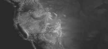
the height data is interesting for the west
a screenshot of the west part of the use from the 7.5 arc sec topo data
--simple cylindrical map projection --
Last edited by johnvanvliet; 08-31-2015 at 04:48 PM.
--- 90 seconds to Midnight ---
--------
--- Penguin power!!! ---
I expect this to be a very interesting thread. The region itself has a complex topography and such diversity.
Is that a picture of your tongue? Just kidding, I do have a shaded relief from Tom Patternson that I used as a base map, but I love having the DEM, which I'll put into QGIS and maybe even exaggerate the height map, the shaded relief for this area doesn't show the variation as much as I'd like to show (artist interpretation) to accentuate the features in this area, even the Grand Canyon looked relatively flat, thanks a ton for providing it.
In my research this morning, there are so many features to show in this area, from the white sands, dunes, dome volcanoe, the hoodoo in Bryce, the Arches in Arches NP, distinct mountains, Half Dome and El Capitan, this is going to be interesting! Maybe an overview map and then more regional/local maps, we'll see.
 Posting Permissions


