Page 1 of 2 12 LastLast
Results 1 to 10 of 13

Thread: Investigation! What can you tell about this house from an 1873 Ordinance Survey map:)

  1. #1
    Guild Applicant Facebook Connected
    Join Date
    May 2016
    Posts
    2

    Default Investigation! What can you tell about this house from an 1873 Ordinance Survey map:)

    Hi guys,

    My name's Joe. I'm from Watford in the UK and have always had an interest in history and local studies! Nice to meet you all

    Recently I've been doing some research into the house that used to occupy the site of my current home. It seems to have been a somewhat large and important house at the time. It was named "Stamford Lodge," built in 1862 and finally demolished almost exactly 100 years later it gave the name to the street opposite and housed up to 12 members of wealthy families with their servants.

    Sadly I've been unable to find any photos, other than one of a corner of it's side
    (it's the house with the chimney furthest to the left (centre of the frame) in the picture)

    Click image for larger version. 

Name:	Stamford Lodge picture.JPG 
Views:	58 
Size:	1.67 MB 
ID:	83903

    Anyway I am in dire need of some map experts who might be able to help me. I've a pretty detailed plan of the house and its grounds off an 1873 OS map and was wondering what could be deciphered from its details? (outhouses, entrances, windows anything really)
    One thing I do know from directories is that it had 3 floors and a basement.

    MAP: Click image for larger version. 

Name:	map of Stamford Lodge.JPG 
Views:	92 
Size:	2.91 MB 
ID:	83905

    LINK TO MAP (if it doesn't work just zoom out and in again) - https://www.old-maps.co.uk/#/Map/510...7568/13/100749

    Thanks so much in advance
    Last edited by Joe Harrold; 05-25-2016 at 02:30 PM.

  2. #2
    Guild Expert johnvanvliet's Avatar
    Join Date
    Jul 2012
    Location
    N 42.39 W 83.44
    Posts
    1,091
    Blog Entries
    4

    Default

    if the UK is like it is here in the states ( on the other side of the pond)

    your local planning office should have the old plans STILL on file
    ( and hopefully NOT ) in a basement in the back corner in a locked file cabinet in a room with a broken light and NO staircase
    --- 90 seconds to Midnight ---
    --------

    --- Penguin power!!! ---


  3. #3
    Guild Applicant Facebook Connected
    Join Date
    May 2016
    Posts
    2

    Default

    Thanks for the idea! I'll check with them

  4. #4
    Guild Expert ladiestorm's Avatar
    Join Date
    Mar 2016
    Location
    North Carolina, USA
    Posts
    1,345

    Default

    You could also check with architects/ contractors that specialize is restoring historic buildings... They would know how to read those.
    Like a thief in the night
    she comes with no form
    yet tranquility proceeds
    the accursed storm...


    check out my new Deviant Art page!
    https://www.deviantart.com/ladiestorm

  5. #5

    Default

    Have you tried appealing for information from the local newspaper. Where I live (also the UK) our local paper (the Dorset Echo) produces a "Hundred Years Ago Today" column, and there are frequently historic pictures in it. There is also a "Can you guess where this was taken" section, which contains photographs right back from the beginning of the photographic era. This means they have an extensive historic archive of photographs taken by their own reporters down through the years, as most likely do most newspapers.

    You could also look up who lived there in the census data, and search those names on sites like Ancestry.com, where family portraits might reveal quite a bit about parts of the house, captured in the background of each shot. It was quite common in the late Victorian period for the well healed to have family portraits taken in the garden with the house in the background. These types of shot vastly outnumber all the other kinds of shot taken of my own family in that period.

  6. #6
    Guild Journeyer
    Join Date
    Jan 2016
    Location
    -0700 GMT
    Posts
    125

    Default

    Unfortunately, at the available resolution not a whole lot. You can see that their is a main entrance and porch? on the SW corner. Then two side doors on the back of both sides. Looks like there is also a carriage house in the north of the property. I'm guessing the Denmark Cottages are not part of the property? Looks like there is a fence or common wall running along the back, though that might just be a property line from the resolution.

    Not sure if you understand how it shows the paths and trees etc. Let me know if you need help finding some examples of how to read blueprints.

  7. #7
    Administrator Redrobes's Avatar
    Join Date
    Dec 2007
    Location
    England
    Posts
    7,196
    Blog Entries
    8

    Default

    Hi Joe,

    I have enhanced the posted image a bit to see it more clearly. I would also recommend looking at the national library of scotland's site which has a nice interface to a lot of old OS maps about that time. I had to do some research of something about 1885 and found a map there. They have the whole UK on OS maps of that time online. I'll see if I can edit in a link to it.

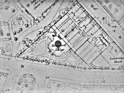
    Seems to be marked as a church on this old map and all the subsequent ones to 1938. Is it a masonic lodge then ?

    http://maps.nls.uk/view/101579898

    Image posted credit:
    Code:
    1. Non-commercial, educational and private use of map images
    
    You are welcome to use most images displayed on the Maps website for non-commercial, educational and private purposes under the terms of the Creative Commons Attribution-NonCommercial-ShareAlike (CC-BY-NC-SA) licence. This includes use in a free exhibition or lecture, or in a university thesis.
    
    Use is conditional on provision of attribution. Please apply the credit line 'Reproduced with the permission of the National Library of Scotland' wherever you re-use map images. If you create derivative work, the documentation of your work must contain this attribution.
    
    For online publications, we request that your attribution includes a link to our Map images website.
    Attached Thumbnails Attached Thumbnails Click image for larger version. 

Name:	OldMap_Enhanced.png 
Views:	24 
Size:	668.1 KB 
ID:	85240   Click image for larger version. 

Name:	OldMap_1899.png 
Views:	13 
Size:	253.6 KB 
ID:	85241  
    Last edited by Redrobes; 07-13-2016 at 08:18 PM.

  8. #8
    Guild Expert johnvanvliet's Avatar
    Join Date
    Jul 2012
    Location
    N 42.39 W 83.44
    Posts
    1,091
    Blog Entries
    4

    Default

    running a "butterworth" reject ring Fourier transform works and normalizing after a high pass
    --- 90 seconds to Midnight ---
    --------

    --- Penguin power!!! ---


  9. #9
    Administrator waldronate's Avatar
    Join Date
    Mar 2007
    Location
    The High Desert
    Posts
    3,554

    Default

    This is one of those situations where grabbing some of the original image data works better than trying to process a really bad photo of someone's monitor. It also shows that the church is next door to the place of interest. The little shaded bleb with ears below the solid black church is Stamford Lodge.

    If you're using Windows and want clean screenshots, get your area of interest on the browser window, then click off the browser and use the printscreen key to grab the whole desktop. Then paste into something like Paint (or better image processing tools if you have them). A lot of pay sites try to disable the printscreen key and this technique usually works around that disable.

  10. #10
    Administrator Redrobes's Avatar
    Join Date
    Dec 2007
    Location
    England
    Posts
    7,196
    Blog Entries
    8

    Default

    Oh yeah I see it now. It even says St Andrews on the map ! I was confused by the scales between them, I used a Fourier process to enhance mine too - more gaussian than butterworth but same thing really. Handy little process that.

    Another thing I found out about a year ago is that in the UK anyone can ask for the legal information from the land registry for a small fee. Now whether this lodge was demolished before the land registry was in place I dont know but it might be worth looking towards them as well.
    Last edited by Redrobes; 07-14-2016 at 05:17 AM.

Page 1 of 2 12 LastLast

Posting Permissions

  • You may not post new threads
  • You may not post replies
  • You may not post attachments
  • You may not edit your posts
  •