

 Reply With Quote
Welcome to the Guild, fellow Atlantean.
Good luck working on this map. What are your goals for it?


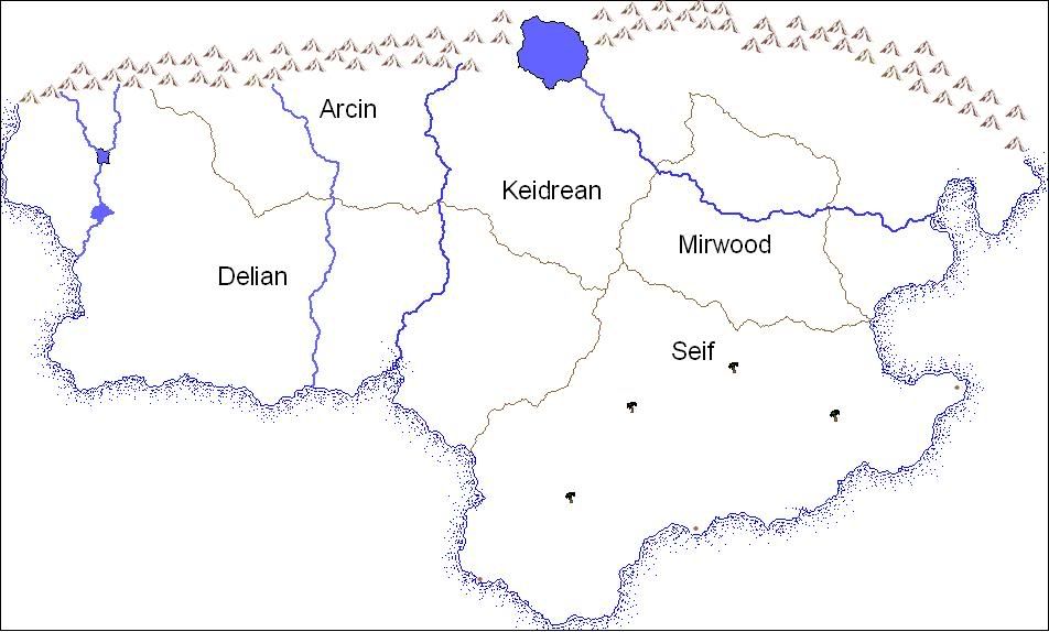
A map I started in AutoRealm and soon will move to GIMP to continue work on. This is for my online Dark Fantasy game (think LotR where the baddies win).
And my 'quick' summery of each realm and the various races within them.
The great human kingdom of Arcin, home of technological wonders that many only dream of, was the first to be crushed under the waves of the Dark Warlord. Their science and steam could not save them, though some think that had the kingdom been prepared perhaps they would have survived. Their great works of science are buried under rubble of their once great cities, the few that remain are in disrepair and few souls know the inner workings of Arcin's great war machines.
Seif, who's lands are those of the great desert sands. The caravans that feed the cities are fewer and fewer as the years go on. The lower Castes rebel against the nobles. Large expanses of desert separate the provinces of Seif, where local governors appointed by the Warlord try to keep order in their more and more chaotic world. Renowned for their archery and javelin tossing skill, but as supplies are hard to find and these desert dwellers port cities are existing on the edge of collapse as the neighboring kingdoms have less to trade for.
The largest of the human kingdoms is Delian. Their influence traverses most of the known world, everything from architecture to weapons that the world knows today has been touched by in some part by the Delian influence. Ruins of cities still stand even after the Invasion and the kingdom was forced to abandon the outer most areas of their territory. Several of the larger cities were devastated by all out war but many others still survive-only just. Their citizenry number only half what they did before the Warlord.
The mighty Dwarven keeps are only two in number now, the rest were sieged to the very earth thst the dwarves carved their majestic halls from. Bloodaxe Keep stands high above the Grey Mountains. There the local dwarven populous has been under digging deeper and deeper in the mountains than any have previously dared. The Bloodaxe family line grows thin, as their hot berserker blood causes them to fall in combat more and more.
The other lone outpost of Dwarves is Krag Keep, which is perched high over looking the Golden Pass through the Dragoon Mountains. There are those who whisper of the Keeps founder, supposedly a Dwarf of divine origins, and that has it that a great dark magic ritual was worked against the Kragborn to keep them under foot. Also the Keep's mines were the deepest and most profitable of any known, but now they supposedly running dry.
From the tree tops of Mirwood and Keidrean forests the Elves strike out at their would be oppressors. Their ones expansive forests have all but been lost, burned for the Infernal war machine. The Elves lash out at any who would attempt to further this destruction. Patrols of elves routinely pick off poachers and others who encroach on their land, but their numbers grow fewer and fewer with each passing season. A lone elf known as Kadajj is said to walk the Seif sands, but little is known of this wanderer. Many believe the Elves to be things of myth and legend.
The half-folk of the world have become more tribal and feral like in nature. They occasionally raid the Seif caravans. Their traditional homes were destroyed within the first few years of the Invasion sending the once peaceful people out into the larger landscape to fend for themselves. Their homes now move almost constantly, much like the Seif caravans they raid. Small scout parties run in front of the main groups, these war dog riding half-folk are known for their fierce fighting for their people. A noble warrior known only as Steel Acorn is buried in the traditional homeland of half-folk , legend say he will rise from his grave to help save his people in their hour of greatest need.
Welcome to the Guild, fellow Atlantean.
Good luck working on this map. What are your goals for it?
I think, therefore I am a nerd.
Cogito, ergo sum nerdem.
Check out my blog: "The Undiscovered Author"
It's the story of a writer... follow me in my simple quest to get published, and share your own writing stories, adventures and writerly tips.
Pimping my worldmap here. Still WIP... long way to go, but I'm pretty proud of what I've done so far...
Thanks Karro!
I'm hoping to flesh the map out. Right now I've only got the major items but no specific cities, forests, and the like. As my online game progresses I'm hoping to add more to the map as well as drawing more local maps for the groups to see what the city they are looks like and what is in the dungeon they're exploring.
Those rivers look better
Glad you fixed the "River Faux Pas"
-Rob A>
My tutorials: Using GIMP to Create an Artistic Regional Map ~ All My Tutorials
My GIMP Scripts: Rotating Brush ~ Gradient from Image ~ Mosaic Tile Helper ~ Random Density Map ~ Subterranean Map Prettier ~ Tapered Stroke Path ~ Random Rotate Floating Layer ~ Batch Image to Pattern ~ Better Seamless Tiles ~ Tile Shuffle ~ Scale Pattern ~ Grid of Guides ~ Fractalize path ~ Label Points
My Maps: Finished Maps ~ Challenge Entries ~ My Portfolio: www.cartocopia.com
Figured I should do correct the rivers before I posted the map again.Originally Posted by RobA


What kind of online game are you producing? Browser based or something else?
Check out my City Designer 3 tutorials. See my fantasy (city) maps in this thread.
Gandwarf has fallen into shadow...
It's a play by post game on rpol.net.
Since you're planning on taking this into GIMP, I assume you're familiar with RobA's GIMP tutorial? Even if that isn't quite the style you're looking to take this map in, if you aren't already very familiar with GIMP, following it will help you learn a lot of the tools GIMP has to offer.
So, do you want to push this more in the hand-drawn style (like what you've already got going, but moreso)? I haven't used it much, yet, but for this style, I wonder if Inkscape (also open source, I believe) might not be a better option... but there's not much advice I could offer on that front.
So, to the map itself: At the mouth of the river that runs down between Arcin and Keidrean, there are a number of blue sea-shore dots that are overlapping the land. Does this represent a swamp? If so, in particular, I'd recommend doing something a little different, primarily because it looks like an error where the seashore design accidentally overlapped the land.
Do the gray lines represent borders betweeen the named regions?
I think, therefore I am a nerd.
Cogito, ergo sum nerdem.
Check out my blog: "The Undiscovered Author"
It's the story of a writer... follow me in my simple quest to get published, and share your own writing stories, adventures and writerly tips.
Pimping my worldmap here. Still WIP... long way to go, but I'm pretty proud of what I've done so far...
I would echo what Karro is saying. For the dots that over lap the land (and you have some in more places than Karro pointed out, though only a few), this is where a layer mask would come in handy. RobA's tutorial is a very good primer in how to use a ton of different GIMP techniques, so if your not very experienced with GIMP, start there.
Also... for the borders, I would think about doing something a bit different. It appears you may be using rivers for borders in some places, but not others and this visual distinction can confuse a reader. For example, Arcin and Keidrian appear to be seperated by the central river... and by the grey line on land. However, this logical division also makes it appear the Arcin is bounded by the river to the West also and Keidrian to the river to it's east. One easy way to avoid this distinction is to make the region names cover their areas more, in GIMP, you could do this using the text tool and a path. Likewise, another way would be to create a political border map where each region has a different color OR possibly a color halo that delineates it's border. Of course the second choice will define your map style to some degree...
My Finished Maps
Works in Progress(or abandoned tests)
My Tutorials:
Explanation of Layer Masks in GIMP
How to create ISO Mountains in GIMP/PS using the Smudge tool
----------------------------------------------------------
Unless otherwise stated by me in the post, all work is licensed under a Creative Commons Attribution-Noncommercial 3.0 United States License.
Joe's remarks are some of what I was getting at regarding both the blue dots and the question about the borders (I was going to point out the potential confusion of whether rivers serve as borders until I knew that's what was represented by the gray lines as well, but there you go, that's it).
Good start, so far, keep us updated!
I think, therefore I am a nerd.
Cogito, ergo sum nerdem.
Check out my blog: "The Undiscovered Author"
It's the story of a writer... follow me in my simple quest to get published, and share your own writing stories, adventures and writerly tips.
Pimping my worldmap here. Still WIP... long way to go, but I'm pretty proud of what I've done so far...
 Posting Permissions


