Reply With Quote
Great work so far Naeddyr and thanks for the great link to the Climate Cookbook, wish i had known about that one before i started
Rep'd
Korba


I give this +2 1/2 additional rats' arses of approval, and I'll throw in an elephant's arse in the bargain. The maps look good, and the work you've done in figuring out the functioning parts look nice. Time well-spent, IMO.
I think, therefore I am a nerd.
Cogito, ergo sum nerdem.
Check out my blog: "The Undiscovered Author"
It's the story of a writer... follow me in my simple quest to get published, and share your own writing stories, adventures and writerly tips.
Pimping my worldmap here. Still WIP... long way to go, but I'm pretty proud of what I've done so far...
Great work so far Naeddyr and thanks for the great link to the Climate Cookbook, wish i had known about that one before i started
Rep'd
Korba

Naeddyr, I came to naive belief that you know all the necessary software and websites for sensible worldbuilding and cartography
First Flex Projector and G.Projector, now Climate Cookbook... what else aces do you keep in your sleeve?
GIMP.org | Inkscape
All my work is licensed under a Creative Commons Attribution-Noncommercial-No Derivative Works 3.0 Unported License unless stated otherwise.
Originally Posted by hunab.cu

Tools
Writing:
yWriter, novel-writing tool
Darkroom style text-editor
Textroom, open-source alternative to above
Maybe you'll like Freemind, a mind-mapping tool. Personally, I like more flowcharty styles, with freer association, while Freemind is a strictly hierarchical thing.
I'll go through my favourites. Man, some of these I haven't even read. It's been years since I went through my favourites properly. Many years.
Zompist's Language Construction Kit
Nyrath's Atomic Rocket pages and stuff
Flags of the World
Creating An Earthlike Planet, parent-page to the Cookbook
The WHKMLA historical atlas
Medieval Technology Timeline
A picture of a huge isopod
Le Sage's Theory of Gravitation
Development of the Chemical Symbols
A list of Human Universals, including MAGIC and SEXUAL REGULATION INCLUDES INCEST PREVENTATION
Chinese Etymological online dictionary
Everything about herbs and spices
Omniglot, writing systems and script online
ZEALANDIA THE CONTINENT
ANIMATED PICTURES OF ENGLINES HUZZAH
CATEGORY: Obsolete scientific theories
Writing Science Fiction and Fantasy
Books to read:
What Does A Martian Look Like despite its US-side title (the original was Evolving the Alien) is a good book on speculation on how far are the borders of life, what kind of things are possible to evolve, etc.
Meme Machine, a basic work on memetics.
Any book on evolution.
Discarded Science, Ideas That Seemed Good At The Time
etc. etc.
NOW STOP PRAISING ME FOR HAVING COOL STUFF THIS THREAD IS ABOUT ME MAP ME MAP ME MAAAAAP
Last edited by Naeddyr; 04-01-2009 at 09:37 AM.
I'd rep you for those goodies, but I'm afraid I can't, just yet. In particular, I'm going to have to check out the usability of yWriter and Freemind as compliments to a tool I use: ConnectedText, which isn't free but is pretty dang cheap (like $30), and has proved pretty useful to me so far in organizing and categorizing my thoughts (using a personal, localized wiki-style that seems to fit pretty well to the way my brain categorizes information). These tools appear to scratch similar itches in different ways, so I'll have to give them a shot.
Last edited by Karro; 04-01-2009 at 06:14 PM.
I think, therefore I am a nerd.
Cogito, ergo sum nerdem.
Check out my blog: "The Undiscovered Author"
It's the story of a writer... follow me in my simple quest to get published, and share your own writing stories, adventures and writerly tips.
Pimping my worldmap here. Still WIP... long way to go, but I'm pretty proud of what I've done so far...
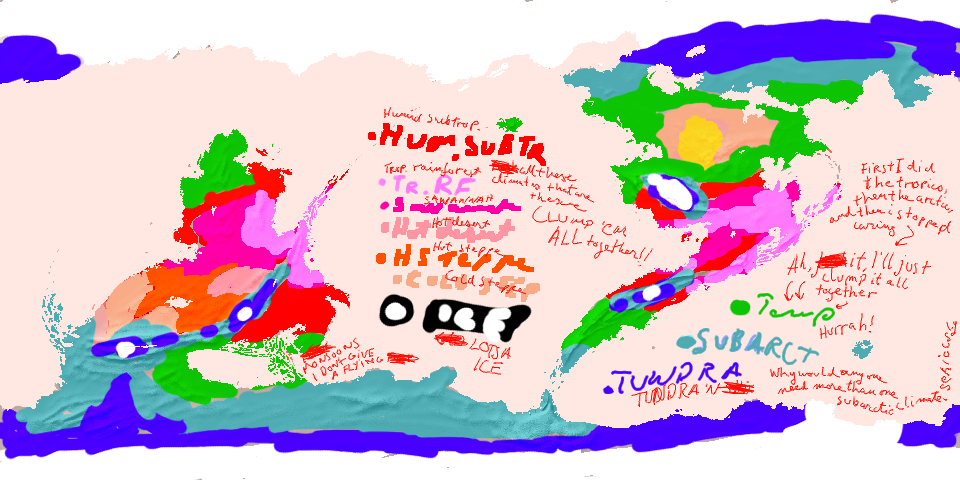
I AM DONE HERE I WILL NEVER EVER DO ANOTHER CLIMATE IN ME LIFE SWEAR TO ATHË.
this map contains naughty words scribbled in a very messy hand parental discretion adviced
i gave up halfway and lumped everything i hadn't done yet (i did the tropics, subtropics, arctic and subarctics in that order) into a TEMPERATE CLIMATE which presumably contains everything from MEDITERRANEAN TO MANCHURIAN TO LAURENTIAN TO STEPHEN FRY
It's not like it will matter because all it'll do is show which kind of tree I'm going to draw on me map, is it going to be an WUNDERBAUM NOVELTY ICE CREAM STICK TREE, LOLLIPOP TREE OR NOODLE MESS TREES for arctic, temperate/moderate and rainforest resp.
You'll notice there's only one hot desert here, in the middle of the Southern Continent, and one cold desert in the northern reachest of the Northern Continent, etc. which suits me fine.
The northern turned out to be much colder than the southern pole, and it's much more covered in glacial ice. the southern pole is warmed by ocean currents and MAGIC~
DID I ALREADY SAY I WILL NEVER EVER DO ANOTHER CLIMATE AGAIN
or if i do
there will be three climate patterns called FATHER BEAR MOTHER BEAR AND CHILD BEAR for tropical, arctic and temperate climates
EDIT:
you have to read this in an Eddie Izzard voice, I've been watching his stuff again on youtube and every. time. I do, I get stuck doing this Izzard impression online. i do it subconsciously.
Last edited by Naeddyr; 04-03-2009 at 08:35 AM.


I completely agree with you on both counts...simple climates and Eddie Izzard.
If the radiance of a thousand suns was to burst at once into the sky, that would be like the splendor of the Mighty One...I am become Death, the Shatterer of worlds.
-J. Robert Oppenheimer (father of the atom bomb) alluding to The Bhagavad Gita (Chapter 11, Verse 32)
My Maps ~ My Brushes ~ My Tutorials ~ My Challenge Maps
Here's a small puzzle for the river constablery. Blue colouring is higher precipitation, white caps are permanent ice (the rivers that originate there are seasonal ice-rivers and ice-rivers in general), and the mountains are, as we say in Finnish, "suuntaa-antavia", advisory in nature, and the rivers are more important than the specific topography given here (which was basically just me scribbling along. I mean, look at the mountain-range on the tail of the Northern Continent! Just horrible.)
There's a lot of huge rivers, which I might scale back.
Just showing some of the progress. This is the part where I do work with Inkscape, collecting all the stuff into a coherent package. This time, I'm doing the two hemispheres separately at first, and the final versions will just be these two combined into one, much simpler that way. I will do several outputs from Inkscape: the "basic" output, which is supposed to be the "looks good" part, without mountains and forests, and two outputs for forests and mountains, so that I can then later-on draw those by hand in GIMP.
The graticules dots were done by first tracing a bitmap of a graticule dot that I had converted with Hugin. This gave me a simple object that I then used to pattern to lines of latitude, using the same method as in RobA's (or was it his?) tapering river tutorial.
Hm, thought of something.
...
Ah yes. That doesn't create a correct graticule dotting. Seems the pattern isn't exactly the same. I will probably something like bitmap trace something that i've transformed with Hugin, later. But not today, it's half past midnight.
Naturally the picture is of the SOUTHERN continent, do not let the name deceive you, I screwed up. I worked on that file for hours and hours, and I never figured out I'd named the bloody thing wrong.
I also came up with a method to create good poles for maps that are without "human" distortion. You know how, if you draw on an equirectangular or other map projection map, where the poles are hugely distorted, you tend to screw things up so that it looks weird if it's in any other kind of projection. I mean the geography is weird, not glitches, etc. Everything looking "pointy". I came up with a way to avoid this pointyness, using Hugin to do some transformations of equirectangular maps, back and forth. Not very complicated, but Hugin being what it is, I'm thinking of doing a tutorial for this. Any interest?
 Posting Permissions