Page 1 of 8 12345 ... LastLast
Results 1 to 10 of 100

Thread: Ysi Earth world map II

Hybrid View

Previous Post Previous Post   Next Post Next Post
  1. #1
    Guild Adept Naeddyr's Avatar
    Join Date
    Jun 2008
    Location
    Finland
    Posts
    300

    Wip Ysi Earth world map II

    Longtimenosee.

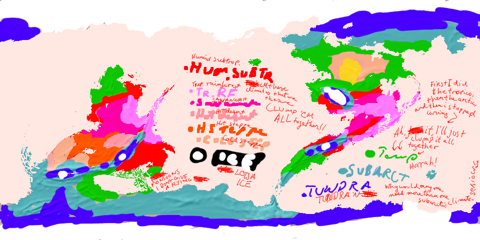
    Recently I got the mapping bug again, so I decided to *this time* get some climates done (may Athë succour my suffering). I also did some modifications of my old base map, to make it seem more interesting and mappy, mostly by adding more geography.


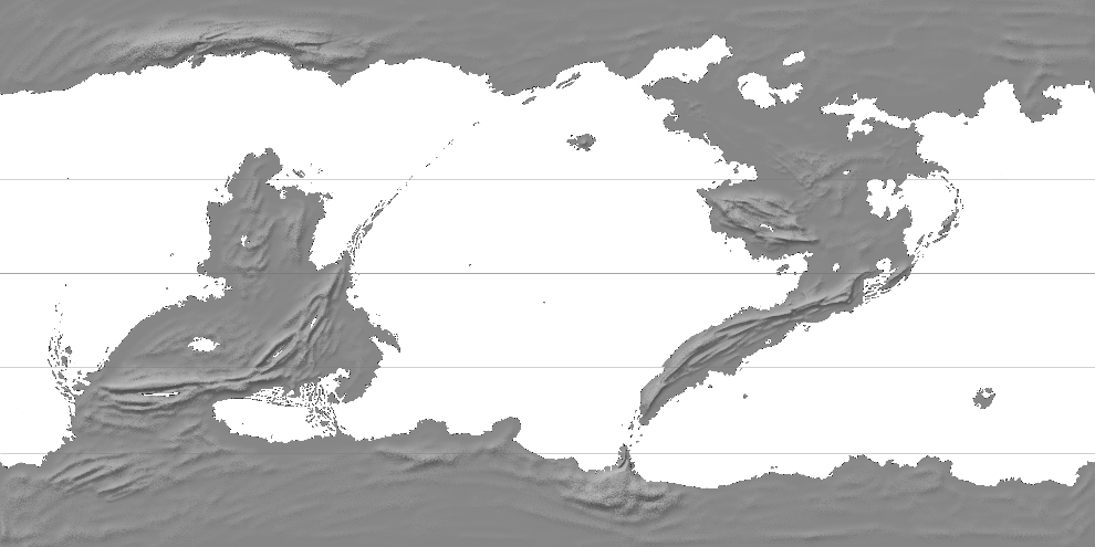
    (equirectangular, mountains are only approximate)

    I realise that there's a lot of archipelago here. What can I say. Did you know that the Archipelago Sea off the coast of Finland is the largest archipelago in the world (if you count by islands)? It's probably true.

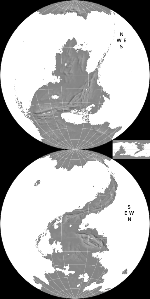
    Like the last map I made, this one will be in-character. It will use a round azimuthal equal area projection (not the more old-timey stereographic as last time), which will be used to depict two hemispheres. The two half-globes will be arranged like this:


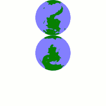
    The edges will meet at the South Pole, instead of the sides, which means that the western hemisphere (which contains the northern continent) will be upside down, rotated 180 degrees. Here's a GIF to illustrate the logic:


    I don't *think* anyone else has done it this way. It adds a bit of fantasy flavah to the whole thing.

    The end result should be yet another printed or handwrought-looking map, so the mountains won't remain like the bumpmapped ones in the above maps, but will be drawn by hand, and there will be very little shading, and more old-timey dithering. I'm thinking of doing a variation of fantasymap mountains using long strings of mountains instead of single peak brushes (much like the "realistic" mountains at http://www.brodt.dk/peter/mount.html ). I will also endeavour to show some climate stuff by drawing appropriate flora and fauna, and I will also add some fantastical beasts onto it, including gryphon-like quadraped and feathered members of an animal family related birds, and four-horned ungulates. The old rivers (though well-policed) weren't based on any climate patterns, so those'll be remade.

    On the sides there will be two astronomical maps: on the left side, three circles radiating from the middle, on which lie the three Moons of Ysi Earth, and on the right (to the East), a Tychonian model of the Ysi Sun, with the diverse planets that orbit it.

    The map will either have two compass roses, or one combined compass rose looking like a Lorraine cross.

    I'm making this topic before starting on the actual mapping part, and I will have to do the climates first. First will come stuff that'll be mostly done with projection converters, Inkscape and mouse, and when I get back to the City from the weekend, I will also have access to my tablet if I'm ready to draw mountains and foliage.
    Last edited by Naeddyr; 03-27-2009 at 02:35 PM.

  2. #2

  3. #3
    Guild Adept Naeddyr's Avatar
    Join Date
    Jun 2008
    Location
    Finland
    Posts
    300

    Post

    Quote Originally Posted by ravells View Post
    I really like the presentation. Is this done with FT?
    FractalTerrains? No, the basic map above (the grey one) was completely created by hand, originally making an outline with pen and paper, including rough tectonics (a year or two ago, for the first Ysi Map). The mountains were drawn by hand (mostly sketchy scribbling) which looks great if you emboss it.

    (I use GIMP to modify the basic map, and then usually import it into G-Projector to convert it into other projections (or flex projector if it's a projection there), which is imported into inkscape to be vectorised and modified and layouted, which is then imported yet again into GIMP to make it pretty. But you should know this already if you've read my tutorial, which you totally have.)

  4. #4
    Community Leader Facebook Connected Ascension's Avatar
    Join Date
    Jun 2008
    Location
    St. Charles, Missouri, United States
    Posts
    8,392

    Post

    Good to see ya back and mapping again since I love the style.
    If the radiance of a thousand suns was to burst at once into the sky, that would be like the splendor of the Mighty One...I am become Death, the Shatterer of worlds.
    -J. Robert Oppenheimer (father of the atom bomb) alluding to The Bhagavad Gita (Chapter 11, Verse 32)


    My Maps ~ My Brushes ~ My Tutorials ~ My Challenge Maps

  5. #5
    Guild Adept Naeddyr's Avatar
    Join Date
    Jun 2008
    Location
    Finland
    Posts
    300

    Post

    Quote Originally Posted by Ascension View Post
    I love the style.

    Then you'll be happy to know there'll be even more of it!

  6. #6
    Guild Novice hunab.cu's Avatar
    Join Date
    Jul 2008
    Location
    Poland
    Posts
    23

    Post

    Wow!

    I always had lots of trouble with projections, and now... Naeddyr, you're my saviour. G.projector and Flex Projector are great. I got quite amazed by what can be done using them.

    And the maps of yours - they are really different from what I've seen here. Looking forward to seeing more of your work!

  7. #7
    Guild Adept Naeddyr's Avatar
    Join Date
    Jun 2008
    Location
    Finland
    Posts
    300

    Post


    I AM DONE HERE I WILL NEVER EVER DO ANOTHER CLIMATE IN ME LIFE SWEAR TO ATHË.

    this map contains naughty words scribbled in a very messy hand parental discretion adviced

    i gave up halfway and lumped everything i hadn't done yet (i did the tropics, subtropics, arctic and subarctics in that order) into a TEMPERATE CLIMATE which presumably contains everything from MEDITERRANEAN TO MANCHURIAN TO LAURENTIAN TO STEPHEN FRY

    It's not like it will matter because all it'll do is show which kind of tree I'm going to draw on me map, is it going to be an WUNDERBAUM NOVELTY ICE CREAM STICK TREE, LOLLIPOP TREE OR NOODLE MESS TREES for arctic, temperate/moderate and rainforest resp.


    You'll notice there's only one hot desert here, in the middle of the Southern Continent, and one cold desert in the northern reachest of the Northern Continent, etc. which suits me fine.

    The northern turned out to be much colder than the southern pole, and it's much more covered in glacial ice. the southern pole is warmed by ocean currents and MAGIC~

    DID I ALREADY SAY I WILL NEVER EVER DO ANOTHER CLIMATE AGAIN

    or if i do

    there will be three climate patterns called FATHER BEAR MOTHER BEAR AND CHILD BEAR for tropical, arctic and temperate climates


    EDIT:

    you have to read this in an Eddie Izzard voice, I've been watching his stuff again on youtube and every. time. I do, I get stuck doing this Izzard impression online. i do it subconsciously.
    Last edited by Naeddyr; 04-03-2009 at 08:35 AM.

  8. #8
    Community Leader Facebook Connected Ascension's Avatar
    Join Date
    Jun 2008
    Location
    St. Charles, Missouri, United States
    Posts
    8,392

    Post

    I completely agree with you on both counts...simple climates and Eddie Izzard.
    If the radiance of a thousand suns was to burst at once into the sky, that would be like the splendor of the Mighty One...I am become Death, the Shatterer of worlds.
    -J. Robert Oppenheimer (father of the atom bomb) alluding to The Bhagavad Gita (Chapter 11, Verse 32)


    My Maps ~ My Brushes ~ My Tutorials ~ My Challenge Maps

  9. #9
    Guild Adept Naeddyr's Avatar
    Join Date
    Jun 2008
    Location
    Finland
    Posts
    300

    Post

    Here's a small puzzle for the river constablery. Blue colouring is higher precipitation, white caps are permanent ice (the rivers that originate there are seasonal ice-rivers and ice-rivers in general), and the mountains are, as we say in Finnish, "suuntaa-antavia", advisory in nature, and the rivers are more important than the specific topography given here (which was basically just me scribbling along. I mean, look at the mountain-range on the tail of the Northern Continent! Just horrible.)

    There's a lot of huge rivers, which I might scale back.
    Attached Thumbnails Attached Thumbnails Click image for larger version. 

Name:	riversandprecipitation.png 
Views:	353 
Size:	442.7 KB 
ID:	12041  

  10. #10
    Guild Adept Naeddyr's Avatar
    Join Date
    Jun 2008
    Location
    Finland
    Posts
    300

    Post

    Just showing some of the progress. This is the part where I do work with Inkscape, collecting all the stuff into a coherent package. This time, I'm doing the two hemispheres separately at first, and the final versions will just be these two combined into one, much simpler that way. I will do several outputs from Inkscape: the "basic" output, which is supposed to be the "looks good" part, without mountains and forests, and two outputs for forests and mountains, so that I can then later-on draw those by hand in GIMP.

    The graticules dots were done by first tracing a bitmap of a graticule dot that I had converted with Hugin. This gave me a simple object that I then used to pattern to lines of latitude, using the same method as in RobA's (or was it his?) tapering river tutorial.

    Hm, thought of something.

    ...

    Ah yes. That doesn't create a correct graticule dotting. Seems the pattern isn't exactly the same. I will probably something like bitmap trace something that i've transformed with Hugin, later. But not today, it's half past midnight.
    Attached Thumbnails Attached Thumbnails Click image for larger version. 

Name:	northerncontinent.png 
Views:	598 
Size:	490.8 KB 
ID:	12053  

Page 1 of 8 12345 ... LastLast

Posting Permissions

  • You may not post new threads
  • You may not post replies
  • You may not post attachments
  • You may not edit your posts
  •