Reply With Quote
Gorgeous maps. I love themOriginally Posted by mat_r
 Hi guys!
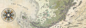
I just finished a couple of black and white maps that I'd like to share with you! I noticed my portfolio is very colourful and it was missing a few black-and-white-style maps, since I would to try to get my work into some novels, if possible.
Since both of these maps have the same style, I thought I'd just share both of them in the same post. The first one, Brenshore, is just a personal exercise, figuring out the look I had in mind for this kind of map. The second one is a regional map for a novel my brother is writing (That's why all the names are in German, sorry)
There's also a short text about the worldbuilding/naming conventions that Julian (the author) wrote for the worldbuilding sub-reddit, in case anyone is interested:
Angorun is a fantasy world in the genre of high fantasy, which i created about three years ago. This map shows only the realm of men during the third age, precisely in the year 1137 a.A. (after Alean).
The original language is german.
Important, yet kind of obvious translations:
Die östliche Passage = the eastern passage
Die nördliche Passage = the northern passage
Westwald = westwood
Die Nordlande = The northern plains
Die Ostküste = The east coast
Die Südlande = The southern plains
D. Sümpfe v. Andeiros = the swamps of Andeiros
Bucht der alten Inseln = Bay of the ancient isles
Grünsteingebirge = emerald mountains
zur freien Stadt = to the free city
About the naming in the realm of men
The nature gods (~3000-1000 b.A)
Even though the faith in the four gods and the one god are most widely spread amongst humans in the year 1137 after Alean, the the old nature gods are still present in the names of the rivers and some mountains all over eastern Angorun.
The early nomads worshipped nature gods, that often represented the immediate surroundings of their tribe's homelands. There were hundreds if not thousands of these gods. During those times it was common for a conquered tribe to renounce their own deity and accept the suppressor´s god(s) as their own. Thus most nature gods disappeared during the long history of the nomadic tribes, resulting in the faith of the Great Seven. (Later the new four gods) These seven are linked in their stories with the movements of the waters of Eastern Angorun. So it isn't surprising at all that the great rivers of this continent were named after them.
An example of this link shows in the troika of Keben, Aurora and Vincis in the north. Keben was the god of craftsmanship and the art of warfare. The river bearing his name splits into the rivers Aurora and Vincis in the city of Avron. Humans interpreted this separation as the incident in the year of the gods, when Keben descended from his throne on the ancient mountain to pass his power on to Aurora (goddess of the sea and fertility) and Vincis (god of victorious battles, of the mist and all the winds). With these powers they could finally end the war of the gods even though afterwards they had to go their separate ways.
The Line of the Kings (beginning at year 0, aka the birth of Alean the great king)
Men weren't always ruled by kings during their history, but the Alean and his descendants influenced the names on this map more than anything.
Only few of the cities on this map still bear their original names. Most people spoke phrygian then. However when King Alean seized power he introduced them to the aeolian language, which he believed to be superior and more noble. Names like Eiren, Avron, Alvas or Kompas stem from this language. These cities bore their own phrygian names before Alean. The king however took it upon himself to eradicate this in every aspect inferior language. Many cities and their regents stood up to Alean during this time. Many fought and many lost and were given their new names by Alean. Few rebelled with great persistence
When Alean´s victory seemed inevitable he confronted all cities that weren't yet under his control with an ultimatum that he believed to be very generous. They were to surrender and keep their cultural identity or to fight, lose and give up their city´s name forever. The map ows some of the exotic names like Tun´bar (The gates of Tun) or Brevin`gard (Brevin’s Keep) to this incident.
The dynasty of Baron de Mansière (~955 a.A.)
The cities Chevrais, Crieste and Nans are different from all other names on this map, for they were founded by a colonial dynasty. The original Baron Mansier lived in Valen’var, the part of the elven realm rather open to outsiders. There he was influenced by both the lydian and the aeolian language. before he died, the Baron changed his name to Mansière and generations later, when his family returned to the realm of men they founded the above-mentioned cities.
Please feel free to share your thoughts, what you like, what I could improve, really anything that comes to your minds.
Cheers!
-matthias