Reply With Quote
Oh wow. I am really interested to see this coming along, what a great project!

It's been a while since I've posted an actual WIP, so I figured I'd make my next one something we don't see here very often.
I don'd tend to post much here and when I do it's invariably something to do with the world that I've been working on for years. Usually it's a new kind of world map or regional map to do with something I'm writing at the moment. This time I'm going to try a globe, which is something I've wanted to do for a long time.
One reason is because a well-made globe of a fantasy world is not something e see very often (to be honest I don't think I've ever seen one before, though please correct me if I'm wrong!), possibly because most fantasy maps are flat and don't take into account the world's curvature. Another reason is just because its something I've always wanted to try, even before I started to dabble in worldbuilding. Another reason is that I think it will help make Elyden seem like a 'real' world.
Why haven't I made one before? Anyone who's tried to make a proper globe with paper gore pasted to a sphere will know just how difficult and precise an ordeal globemaking really is. Assuming you're using 12 gores, each of 30 degree (I'd prefer 18-24 separate gores, but I'm yet to find a program I like that can make more than 30 degree gores), I might cut the gore too small, or the sphere might not be perfect - every error has a cumulative effect on the next gore, and the next gore... until the last gore glued onto the sphere overlaps with the first one. not good! And most importantly - gluing flat pieces of paper to a sphere is incredibly difficult to do without either ripping the paper or creating folds. The globe itself will be 25-30cm in size depending on the polystyrene spheres I find.
***
So that's enough preamble. Here's the first WIP of the map:
where possible I plan on making each individual label (yes, there will be lots of labels ... :p) self-contained within an individual gore, as splitting text between gores will not be easy to do. Obviously it's not something that can be completely avoided, particularly with large labels, like oceans.
The poles will be individual discs 10 degrees wide that will be stuck to the top of the globe. I haven't started work on those yet, though have a good idea of how work will progress.
I really hope this materializes. The digital map will not be much of an issue. It's the physical globe that's worrying me. I'm going to be doing some dummy globes with smaller spheres to test out the gluing and overlapping, which are the things I'm the most perturbed by


Oh wow. I am really interested to see this coming along, what a great project!
Meshon's Cobblestone Streets tutorial
DeviantArt page: https://meshon.deviantart.com/
Follow me on Twitter! @meshonlive https://twitter.com/meshonlive
I actually already came across my first snag - the lines of latitude are straight (parallel) in the WIP i posted above. That's fine for a flat sinusoidal map, though once i print out the individual gores and stick them to the sphere, the lines of latitude will not be circular. Imagine the gores I posted above have been stuck to a sphere, now look at the 80th parallel N (right at the top) - the lines are all straight, like a polygon. They should be round. So I'm looking for plugins for photoshop i can use instead of G Projector for making the latitude lines round. I found something called flexify, though I'm still working on whether or not its precise enough for my needs...
FWIW, the Generic Mapping Tools (GMT) look like they should be able to do what you want (produce an interrupted map with curved lines of latitude near the poles). An example script is shown at http://gis.stackexchange.com/questio...-for-rectangul
Obtaining GMT for Windows might be a problem. (I couldn't make heads nor tails of the installation instructions on its web site.) It installs trivially under Scientific Linux, though, since it's available from the epel repo. (i.e. yum install gmt)
ETA:
Windows installers are available at https://www.soest.hawaii.edu/gmt/gmt...ows_SOEST.html
Last edited by selden; 11-20-2015 at 06:42 PM.
Selden
Thanks for that! I was able find a Photoshop plugin (flexify) that did whatni wanted and more. The filter takes a while to work (base file is quite big) and only works 1 layer at a time but I can pick how many gores I want, as well as generate usable graticules in the filter which will save me a lot of time.
So that's the first hurdle overcome...
the netppm tool "ppmglobe" works
36 gores
Code:ppmglobe --background=grey 36 10ppd.lines10.ppm > 36.ppm
this 3600x1800 image took less than 1 second
now for gluing to a sphere you will need to stretch the paper ( the same way you would for leather )
the center of each gore needs to bulge out a bit , the more gores the less of a bulge is needed
Last edited by johnvanvliet; 11-21-2015 at 01:14 AM.
--- 90 seconds to Midnight ---
--------
--- Penguin power!!! ---
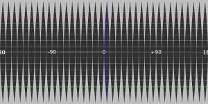
I had thought of that but the lines of latitude are parallel. they need to be sickle shaped, like this:
I still need to do some work on the layer styles for the land (at the moment there's a lot of unwanted inner glow etc. that needs to be removed.Note the latitudes, especially at the poles - they're curved, which is just what I was looking for
WOW! I am really impressed by your Globe WIP!
How much will be the diameter?
thanks, I was planning on 30 cm (so each gore needs to be 47.12 cm high). In my head it seems too small, though when i measure out 30cm and imagine a sphere that size, it's more than big enough
After a long time without updating (Ive been busy working on my atlas), Im back with an update (ok, its just a gore map, mkIII, but bear with me please).
Id paused working on this after launching my Patreon as I decided Id keep the globe as a reward for myself when I reach a certain number of Patrons. Though a relatively small amount, I didnt think id reach it this quickly so it came as a surprise when I got the news in my inbox!
So work begins anew on the globe. Ive reworked the base map after deciding to go for a simple black and white image that Ill paint once its stuck to the globe. That should keep the printing costs down and help me exercise my painting skills, which I havent used in ages.
My work on the map also led me to cracking something Ive been flummoxed by for a long time now - the Nullambit.
The Nullambit: is a region and supranatural phenomena that spans the globe, at an angle to the equator. It is equidistant from the Atramental and Firmamental fonts (the Black Fountain and the Menisucs; at 8o5733S 27o5620W and 8o5733N 152o0340E, respectively) and is the farthest point from the two regions, circumventing the globe of Elyden.
The closer one gets to the Nullambit the weaker the effects of the Atramenta and the Firmament become, making shaping and technarcane use a lot more difficult. The farther one moves from the Nullambit (and closer to the antipodes of the Black Fountain or the True Meniscus) the stronger relative shaping becomes and the more pronounced the respective effects become. Within a radius of 10 - 100-miles of the antipodes survival becomes close to impossible, with both the Atramenta and the Firmament coming up many horrific and inventive ways of debilitating and killing mortal life there.
TLDR: its another equator at a tangent to the real one, whose poles are the two magical fonts, which are antipodes.
Id been struggling to get this properly depicted on a map and after lots of maths, messing about with projections, flipping things back and forth, I gave up, knowing Id have to revisit it at some point. When I end up wasting loads of time on something without progress, I;ve learnt to let it go, and then come back to it later with a fresh perspective. And lo, thats what I did and it worked.
Now I can go back and add the proper Nullambit to my finished maps and the atlas maps too.
So now thats out of the way I can concentrate on the actual map, though I wont be going overboard with the labels (mostly due to the annoyance of having to split up names between gores)! - so just nations, capitals, major cities and landmarks that are pertinent on such a scale, sea routs, trade routes, rivers and the lagest geographical features.
 Posting Permissions