Page 1 of 2 12 LastLast
Results 1 to 10 of 19

Thread: Village of Albridge - Developed draft, need input

Hybrid View

Previous Post Previous Post   Next Post Next Post
  1. #1
    Guild Novice
    Join Date
    Oct 2012
    Location
    Calgary, Alberta, Canada
    Posts
    23

    Default Village of Albridge - Developed draft, need input

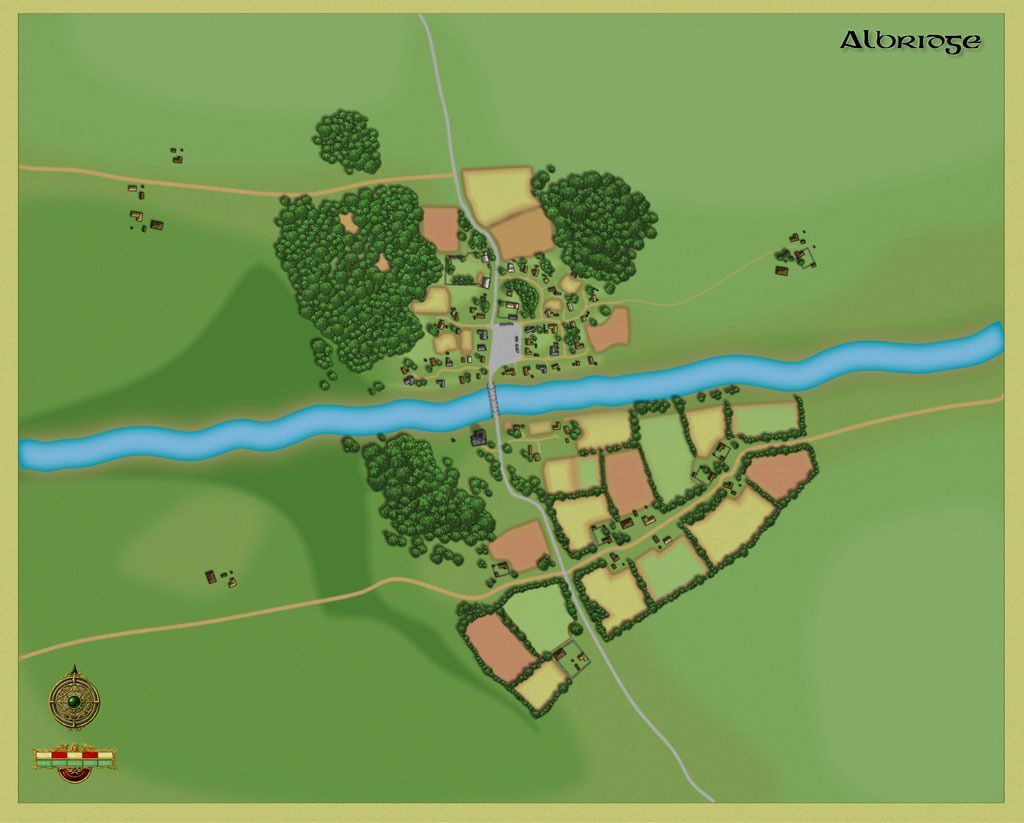
    This is my second crack at using CC3, this time with the City Designer set. Overall I'm reasonably happy with it, but now I need some input.

    This map is an expansion of an existing map found in the D&D Adventure "Reavers of Harkenwold" found in the Dungeon Master's Kit in their essentials line. As part of the adventure, and hopefully without too many spoilers, the heroes participate in the "Battle of Albridge" which is a series of three encounters set just to the south of the village. However, in advance of the battle, the characters are supposed to help the raised militia of the town in planning the defense of the town. As such, I know that my crew will want to have much more than just the close-in village map, but rather a larger map that includes the surrounding area, but is still close-enough in to see the various buildings, fields, hedgerows etc... So I started building this map, but am now at a point where I need some critique and input.

    Here's what I have so far:


    If you want a much larger version go here:
    http://img.photobucket.com/albums/v5...raft-Large.jpg

    The central part of the village is developed directly from the map from the adventure itself. I imported a bitmap of the town map, and simply drew over top of it. The original map went from just below the dirt road at the top of the picture, to just south of the river with the buildings and fields that hug the shoreline. The width of the map is determined by the inner part of the two forested areas on either side of the town north of the river. Outside of that, the design part is mine, including the hedge-lined fields south of the river.

    The scale marker in the lower left corner indicateds 500 feet... so this map is approximately 1 mile x 1 mile in terms of area. The battle in question will involve approximately 200 soldiers on either side, so this is not an unrealistic size for that kind of a fight.

    What I want to do is flesh out the map well, but provide some stuff of tactical interest. I'm trying to build in a steep-ish forested ravine in the darker areas on the west side of the stone road so that it gives some focus as to where the battle is most likely to take place (southeast). However, I want the whole map fleshed out, rather than me looking lazy the further out from the center I get.

    I'd appreciate any input you might have for me.

  2. #2
    Guild Adept atpollard's Avatar
    Join Date
    Dec 2011
    Location
    Florida
    Posts
    331

    Default

    First, great map!
    Looking at the larger version is definitely worth the effort.

    Now, some hopefully helpful nitpicks.
    The buildings and trees cast shadows from a light source in the lower right corner of the drawing (physically more accurate, but typically less common than an upper right light source). The word "Albridge" casts shadows from an upper left light source. Good job shading the trees, but the darker and lighter greens (shadows and highlights) also indicate a upper left light source. You will want to get all of the light source ques to agree.

    Sorry, but I don't know enough about CC to be sure that this is helpful, but I love your color shading work and think that a faint texture overlay would really make the water and grass fields pop. Or perhaps a very faint 'cloud' overlay to provide some variation to the large semi-homogeneous areas of grass. Again, sorry but I described the suggestions in Photoshop Terms (that I know) rather than CC terms (which I am unfamiliar with).

    This is purely a personal preference, but I like the clean simplicity of the map rendering and think that the title matches it well, but the compass and scale bar seem a litthe too fussy compared to the clean style of the map ... others may disagree since this is really a personal preference rather than technical observation.

    Have some REP for a great map that made me smile.

  3. #3
    Guild Adept atpollard's Avatar
    Join Date
    Dec 2011
    Location
    Florida
    Posts
    331

    Default

    Quote Originally Posted by Agatheron View Post
    I'm trying to build in a steep-ish forested ravine in the darker areas on the west side of the stone road so that it gives some focus as to where the battle is most likely to take place (southeast).
    I'd appreciate any input you might have for me.
    A couple of questions.
    Is the dark area the limits of the ravine? Would the center of the dark area be the lowest point?
    More detail on your intent would help others offer more specific advice.

    My only immediate observation is that the road appears to ignore the ravine slopes completely. It should probably do something. A narrow log bridge over it, or a switchback along the slopes or divert around the ravine … something.

  4. #4
    Guild Novice
    Join Date
    Oct 2012
    Location
    Calgary, Alberta, Canada
    Posts
    23

    Default

    The ravine was the most recent addition, so I have yet to adjust the road accordingly. My intention is to heavily tree up the east side of the steep slope to make it difficult for formations of troops to move through and flank. Thanks for noticing the shadowing issue. Cc3 has a global sun feature that you can turn on and off for each layer. I expect that I'll have to look a bit closer with each of the sheet effects to make sure everything is pointed in the same direction.

    I'm most interested in how far the cultivated fields should extend beyond the buildings... Or should those areas further out from the buildings be more pasture type land. Thanks for the suggestions so far, this one is still very much under development...

  5. #5
    Guild Master Facebook Connected jtougas's Avatar
    Join Date
    Sep 2010
    Location
    Wales Massachusetts
    Posts
    2,813
    Blog Entries
    27

    Default

    I would say that unless this is the "bread basket" of the region that you probably have enough fields. Pasture or grass lands out side of the immediate area would be realistic.
    I am the breath of Dragons...The Song of Mountains...The Stories of Rivers....The Heart of Cities.... I am A Cartographer....

    Finished Maps
    Kingdom Of Shendenflar Campaign Setting (WIP)

    Everything I post is free for use and redistribution under the Creative Commons Attribution-Noncommercial-Share Alike 3.0 licence, except where noted otherwise in the thread.

  6. #6
    Guild Novice
    Join Date
    Oct 2012
    Location
    Calgary, Alberta, Canada
    Posts
    23

    Default

    Quote Originally Posted by jtougas View Post
    I would say that unless this is the "bread basket" of the region that you probably have enough fields. Pasture or grass lands out side of the immediate area would be realistic.
    Okay. I still expect to put a few smaller fields around the outlying houses that don't have them. According the fiction info, the primary "bread basket" for the region is more in a village about 10 miles east, as it is very specific about having vineyards, apple orchards, and grain fields.

    Hm... maybe I should add an orchard or two as well as some pastureland.

    @ravells: Thanks for the tip on the river. It's a texture fill. I can swap it out with a darker water colour... Right now I've not done too much in the way of the river. It's effectively a fractal line with a texture fill that relies on the sheet effects to give an appearance of a shoreline. It's a slow-moving river, about 200-300 feet wide, more typical of those found in England. It does need a bit more character in this map.

  7. #7

  8. #8
    Guild Novice
    Join Date
    Oct 2012
    Location
    Calgary, Alberta, Canada
    Posts
    23

    Default

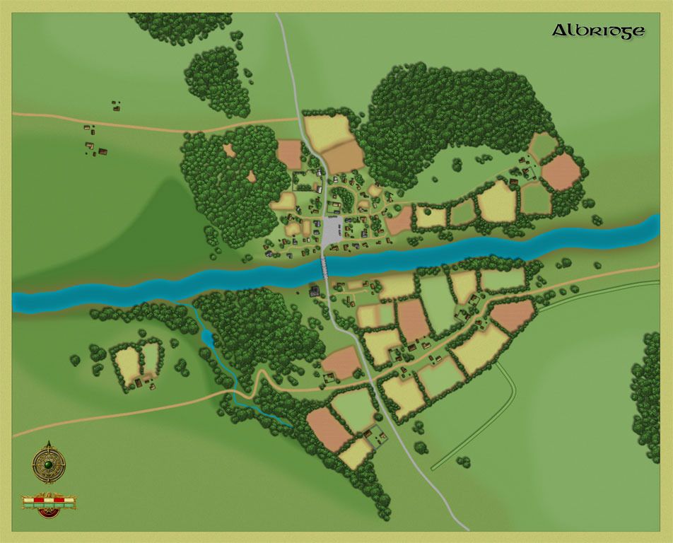
    Right... after taking in some suggestions I've made some modifications and added to the map. Still not done. I added some earthworks in the lower right, but I'm not convinced I need them given that they're not anywhere else on the map. Also, the trees that line the fields are intended to be more hedgerows. I may separate them off onto a different sheet and lower their shadows to make it distinctive that those pieces are short hedges and don't block line of sight as much. Anyway, here's a smaller picture of how it looks:


    And if you want to get in really close:
    http://img.photobucket.com/albums/v5...raft-Large.jpg

    I've also added a spring-fed creek to emphasize the ravine in the lower part of the map. Hopefully that will direct the overall expectations of the battle to the southeast part of the map. Of course, I'll still have some skirmishers try to flank, but assuming the heroes secure an alliance with some elves, they'll be holding down that part of the flank with little difficulty

  9. #9

    Default

    Great map! I like it. I am not familiar with the module but you asked for comments and suggestions though so I shall throw some out there:

    You might have some fenced common grazeland for livestock in a village this small. Keep in mind your fallow fields too. You're always going to get a few more fields than are actually used each year. Also you appear to have a paved road which suggests a past or present efficient infrastructure. You may have a building (a waystation, former state funded "inn" or the like) sitting along it.

    If it's a frontier village, you might have a bank and ditch on the sider of the river that points towards the frontier. Earthwork defences require less sophistication than palisades and walls and tend to be more common. If there was any defensive structures here in the past, the old earthworks may still be present.

    I would ditch the scale bar and just keep a simple compass for direction. If north is always assumed to be the top on your village maps, you may not even need that.

    You may have a simple dock or even just posts if there are other villages and such on the same river. The river seems quite big and it'd be used as a transport link. You can move a lot of goods by barge far easier than you can by cart afterall.

    To better represent the ravine, you might want a slightly more stone-like effect with appropriate light and shadow. This is a bit more arty though and you'll need to consider light direction and such. Contour lines of some kind or the embankment dashes are another option.


    That's quite a bit but really they're just minor things you might consider but don't really need. I think the map is fine as it is. It conveys plenty of information and is clear and legible and it looks good.

  10. #10

    Default

    This looks pretty good, and people appear to have given you some pretty good advice. Very clear and nicely higgledepiggledy.

    There are a couple of things I've noticed though, but they are dependent on the world Albridge is set.

    First, I notice that the there is a large paved area presumably for a market. In a medieval setting, that paved area would be very expensive, so the market must bring a lot of business into the village (actually, the number of houses would indicate that it's more of a small town).

    Second, whilst there is what looks like a manor (the walled set of stone buildings in the centre) in which the village's owning lord would reside, there doesn't seem to be a place of worship for whatever gods your people follow. Again, this is dependent on the setting, but most medieval villages (especially of this size) had a church.

    Third, what are the the little group of buildings in the northwest? It seems odd that they have no fields or pasture around them. Unless they're a leper colony!

    Finally, I'd agree that an area of common land and more fields would be a good idea as there doesn't seem to be enough to feed everyone living there and have leftovers to sell at their great big market. The peasants would be alloted their own small plot of land for subsistence farming and be expected to farm the lord's land. Additionally in a medieval village the fields would be mostly strips of land - but that isn't something I'd worry about as it looks good as it is.

    Sorry if this comes across as a bit negative, I do actually like what you've done.
    Last edited by Lorgath; 11-03-2012 at 11:00 AM.

Page 1 of 2 12 LastLast

Posting Permissions

  • You may not post new threads
  • You may not post replies
  • You may not post attachments
  • You may not edit your posts
  •