Page 1 of 2 12 LastLast
Results 1 to 10 of 13

Thread: The Hourglass of Zihaja: The World of Siraaj

  1. #1
    Guild Apprentice Zeta Kai's Avatar
    Join Date
    Oct 2008
    Location
    Moving up north
    Posts
    35

    Map The Hourglass of Zihaja: The World of Siraaj

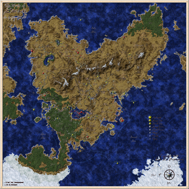
    This is the continent of Admaja, on world of Siraaj. It is a companion piece to the corresponding map of the world of Najmah. It was made in Photoshop CS3 & Illustrator CS3 for a homebrew campaign setting called the Hourglass of Zihaja. It is an Arabian Nights based setting, made from the votes by the members of the Giant in the Playground homebrew forum.
    • Text in dark green is a settlement.
    • Text in dark brown is another location, such as an adventuring site, a geographical feature, or a region.
    • Every settlement larger than a thorp has a name.
    • Settlements in yellow are major cities.
    • Settlements in gray are lesser towns & villages.
    • Settlements in red are former towns that are uninhabited &/or in ruins.
    • Locations with a star on them are prominent locales (IE something that I have a lengthy description for).
    • The scale is in the lower-left corner, opposite the compass rose.
    • The blue lines in the oceans are major oceanic trade routes, which are mostly for the pahari & the marid genies.

    Those mountains nearly killed me. The names of various places are taken from actual Arabic, the Admajai conlang, ancient Persian places, & authentic-sounding gibberish. The whole thing was made by painting it in Photoshop using my normal mapping techniques, tracing it in Illustrator to lay down the rivers, roads, & settlements, then porting it back to PS at a much high resolution & laying down more detailed textures on top of everything, & piling on filter after filter; I used some methods from Pasis, Ascension, RobA, & Tear. I hope you like this map in direct proportion to how much time that I spent working on it.

    For some reason, I've had trouble uploading images here in the past, & the big map is huge (4,925×4,925 pixels), so click on the thumbnail below to be linked directly to the big map hosted on DeviantArt.

    Last edited by Zeta Kai; 03-12-2011 at 03:14 PM.

  2. #2
    Guild Journeyer
    Join Date
    Oct 2007
    Location
    Sunshine Coast, BC, Canada
    Posts
    134

    Default

    Excellent Map! I think it may border on over labled/crowded, but still clear and readable. Your Ice Texture is perfect, and the detail in the compass rose is perfect (that is the same continent in the rose as depicted in the map right) Zimzalad... the icon is alone, is it a small island, underwater city? There are a couple like that... I am guessing islands To quote the "new" Scotty "I like this ship, Its exciting!" Repped

    PS where is that Ice Texture?

  3. #3
    Professional Artist Guild Donor Sapiento's Avatar
    Join Date
    Jul 2009
    Location
    Salzburg, Austria
    Posts
    3,655

    Default

    Wonderful map!

    The ice texture looks like a stone texture covered with white. Am I right?
    Last edited by Sapiento; 11-24-2010 at 02:09 AM.

  4. #4
    Guild Apprentice Zeta Kai's Avatar
    Join Date
    Oct 2008
    Location
    Moving up north
    Posts
    35

    Default

    Quote Originally Posted by Lathorien View Post
    Excellent Map! I think it may border on over labled/crowded, but still clear and readable. Your Ice Texture is perfect, and the detail in the compass rose is perfect (that is the same continent in the rose as depicted in the map right) Zimzalad... the icon is alone, is it a small island, underwater city? There are a couple like that... I am guessing islands To quote the "new" Scotty "I like this ship, Its exciting!" Repped

    PS where is that Ice Texture?
    Yes, it is a bit... detailed, but I wanted to include as much information for the DM as possible. I have an unlabeled version, which I will be posting in a separate thread.

    Thank you for the compliments. Yes, the world in the compass rose is a rendering of the same planet, so the Central Continent is quite prominent under those clouds.

    As for Zimzalad & the other cities out in the middle of the oceans, those are the cities of the marids (water genies). The whole world is based on Arabian mythology, so genies are featured heavily. The marids live in underwater settlements, which have become trade hubs over the past few centuries.

    If I can find that ice texture, I'll post a link. I have a nasty habit of devouring texture websites, gobbling up images & filing them away in folders on my computer, without regard for where they came from. So when someone asks where something came from, I'm usually at a loss.

    Quote Originally Posted by Sapiento View Post
    Wonderful map!

    The ice texture looks like a stone texture covered with white. Am I right?
    Close, but no cigar.

    And thank you, as well. I like your maps, too. I may post a tutorial on my techniques, as I think that they will be helpful for artists who don't like to use brushes too extensively. Believe it or not, most of this map was made without using brush tools at all!

  5. #5

    Default

    This is a nice map although I didn't really look at the compass rose until Lathorien pointed it out. The globe in the middle is a really nice touch! I like the textures and icons used and I don't think it is too crowded with labels, but I do think the outer glow on them could be a little brighter so they stand out more. It looks great though and it is big!

  6. #6
    Community Leader mearrin69's Avatar
    Join Date
    Sep 2009
    Location
    Portland, OR
    Posts
    2,318

    Default

    Looks great. I like your icons. Have some rep!
    M

  7. #7
    Guild Apprentice Sonnenfalke's Avatar
    Join Date
    Aug 2010
    Location
    Rhineland-Palatinate, Germany
    Posts
    47

    Default

    Great map ... really man ... I want to have those map icons ^^
    http://www.cartographersguild.com/signaturepics/sigpic27022_1.gif

  8. #8

    Post woot

    the sea is wonderful , the icons are too saturated in my opinion. It's nice and you can comfortably play rpgs on it

  9. #9
    Community Leader Facebook Connected Steel General's Avatar
    Join Date
    Jun 2008
    Location
    Ft. Wayne, IN
    Posts
    9,530

    Default

    Nicely done, you might consider doing something with the key/legend - it gets a bit lost in the ocean. Maybe put some kind of scroll/parchment behind it. *shrugs*
    My Finished Maps | My Challenge Maps | Still poking around occasionally...

    Unless otherwise stated by me in the post, all work is licensed under a Creative Commons Attribution-Noncommercial 3.0 United States License.


  10. #10
    Guild Apprentice Zeta Kai's Avatar
    Join Date
    Oct 2008
    Location
    Moving up north
    Posts
    35

    Default

    I'm glad that my map was warmly received. My past few maps had not gotten a lot of response, so I'm glad that I stuck around & tried again. I've been sitting on these maps for a long time, until the project that they are associated with was published.

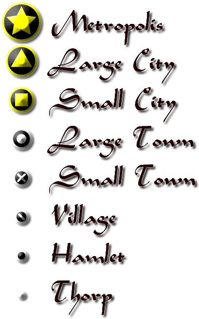
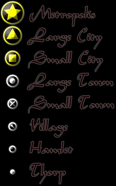
    As for the map icons, I'm very pleased that you guys like them. I designed them so that D&D players (& especially DMs) could tell at a glance what size category a particular settlement was. For those who expressed interest in them, feel free to use the images below for your own maps. No need to credit me or anything; just enjoy.


Page 1 of 2 12 LastLast

Posting Permissions

  • You may not post new threads
  • You may not post replies
  • You may not post attachments
  • You may not edit your posts
  •