Page 1 of 2 12 LastLast
Results 1 to 10 of 16

Thread: Request for a political map

  1. #1

    Default Request for a political map

    Hello! I am Zanannia, I also go by Zann. This account is named after the nation I RP as on an online sim game called NationStates, as you might have heard of it, you guys probably get requests from there all the time. I am looking for someone who would be kind enough to make a map for me.

    I am simply looking for a simple political map to use. I am kind of letting the mapmaker's creativity loose a little bit, as I only need a few guidelines:
    • The map itself should only include a continent (what it is shaped like is up to you), and an island system consisting of a handful of islands off the west coast of aforementioned continent.
    • The land mass should be divided into 15 districts, including the islands.
    • What you name them and what size they are is up to you, I only request that there be a district in the middle of the continent named Japosyia. In this district lies my capital city, Ambergrove. Also, the archipelago needs to be named the Lilac Islands.
    • In terms of scale, the continent is 6,632,700 miles square, but you can approximate that if you wish, I don't really care too much. The island system is about the size of Japan.
    • On the northeast corner of the continent there needs to be a small separate nation named the Malkakhian S.S.R. Do not count it as one of the districts. Obviously the nation that takes up the rest of the continent and owns the island system is Zanannia.
    • I don't really care what size it is, as long as it is big enough to see very easily with the naked eye, meaning no smaller than 3 x 3 inches.

    Other than that, I really don't care as long as it looks like a legitimate political map. As for copyrights, you as the maker get to keep full rights for the map, I simply ask that I be allowed to use it for RP purposes on NationStates. You don't need to be a professional, I simply ask that it look acceptable.

    Here is an example of what I am asking for. It does not have to look like this (in fact I rather it not), but I would ask that it at least be of the same quality.
    http://i97.photobucket.com/albums/l2...s/Ardanan2.png

    There is no time limit, I simply ask that you give me your word that you finish it as soon as you can.

    I really appreciate it!

    -Zanannia
    Last edited by Zanannia; 01-02-2011 at 04:55 PM. Reason: Changes to guidelines

  2. #2
    Community Leader Jaxilon's Avatar
    Join Date
    Nov 2009
    Location
    A beach in Ecuador
    Posts
    5,548

    Default

    You do mean 6,632,700 miles square and not
    Quote Originally Posted by Zanannia View Post
    6,632,700 miles squared
    , correct? The first is just a little bit smaller than South America and the second is well, 43,992,709,290,000 or almost 44 Trillion square miles. That would be like WAY bigger than all of planet earth. Ok, after figuring that out, I'm going to go out on a limb that looks like the size of a Redwood and say that the "d" is a typo.

    So the size of South America with a lot of districts. That is a lot of districts.
    “When it’s over and you look in the mirror, did you do the best that you were capable of? If so, the score does not matter. But if you find that you did your best you were capable of, you will find it to your liking.” -John Wooden

    * Rivengard * My Finished Maps * My Challenge Maps * My deviantArt

  3. #3

    Default

    Yeah the d is a typo, also, I think I am going to go ahead and change the district number to 15....
    Last edited by Zanannia; 12-31-2010 at 06:32 AM.

  4. #4

    Default

    By the way, I try to describe it in the OP as best as I can because I am not any good at making things on the computer. I mean, I can't even use Paint without having to call tech support... Me trying to make a prototype of what I want would simply confuse you...

  5. #5
    Community Leader Facebook Connected Steel General's Avatar
    Join Date
    Jun 2008
    Location
    Ft. Wayne, IN
    Posts
    9,530

    Default

    You could always sketch it on paper and scan it...
    My Finished Maps | My Challenge Maps | Still poking around occasionally...

    Unless otherwise stated by me in the post, all work is licensed under a Creative Commons Attribution-Noncommercial 3.0 United States License.


  6. #6
    Community Leader Jaxilon's Avatar
    Join Date
    Nov 2009
    Location
    A beach in Ecuador
    Posts
    5,548

    Default

    or take a picture with a digital camera and post that.
    “When it’s over and you look in the mirror, did you do the best that you were capable of? If so, the score does not matter. But if you find that you did your best you were capable of, you will find it to your liking.” -John Wooden

    * Rivengard * My Finished Maps * My Challenge Maps * My deviantArt

  7. #7

    Default

    Ok, I will try that....

  8. #8

    Default


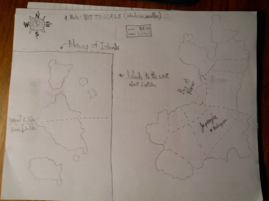
    This is a sketch of the continent and the islands to the west. Whatever I have named is what I want on the map. The rest is yours to name and go crazy with!

    On the island blowup, the horizontal dash line signifies how I want the islands separated district-wise.

  9. #9

    Default

    Also, feel free to do what you want with the district lines. As long as there's 15 on there, I won't mind.

  10. #10

    Default

    Also, I forgot to add the small nation that's on the topmost part. So consider that top district Malkakhia...

Page 1 of 2 12 LastLast

Posting Permissions

  • You may not post new threads
  • You may not post replies
  • You may not post attachments
  • You may not edit your posts
  •