Page 1 of 2 12 LastLast
Results 1 to 10 of 14

Thread: I see a world through a glass darkly

  1. #1
    Guild Apprentice Adolon's Avatar
    Join Date
    May 2013
    Location
    Virginia
    Posts
    33

    Help I see a world through a glass darkly

    I see in a lot of the tutorials that I have found in regards to world-building, that the first step is having a map already in mind: you have the map and then you begin plotting the cities and countries.

    I'm sure this has happened to lots of people but I've jumped the gun. I've put the carriage before the horse. I've got the peoples and countries, I've got the cities and their names, I have landmarks, but no land to place them on. So when I begin to describe the relationships between locations, they are always foggy or blurry. I have no physical material to work off of. I am just making it up as I go along with no destination in mind.

    So my question is this: How do I come up with a map for a world when I already have countries, their cities, and their geographic locations (one is more north than another, etc.) already made? I have played around with Fractal Terrains but nothing it makes satisfies me (no offense to its author) and I don't want to be pressing the dice button to make a new seed for the rest of my life. To use another metaphor, I feel like I am trying to stick a circle peg into a square hole.

  2. #2

    Default

    I suppose you could not worry about drawing an actual map, and instead read over your notes and other material. Then just draw a square for one of the main countries/peoples. Following that, place additional squares in relation to the others based on what your relationship notes say. Maybe use bigger squares for larger nations. Or rectangles if it's a long narrow country. Likewise, if a city in one square has a river running through it, make a note of that. If one country is supposed to have mountains in the east, note that on the left side of that country's square.

    And so on. You will likely get some conflicting material but that is good because you know what details you need to iron out.

    The end result should give and idea of where each country is going to go. It will tell you that a river runs through certain parts of the map, that mountains are in another part. After that you are just filling in the blanks and making it into an actual map. Drawing proper coastlines, finishing the courses of rivers, completing the mountains, etc etc.

    I think that is what I would do.

  3. #3

    Default

    Start with a sketch using pencil and paper. Move features around until they are consistent with whatever explanatory text you've made up for them - you may find that you might have to change the text to fit the map in parts where there is a circle that cannot be squared. Descriptions of people and places often give clues to the environment. Are the people dark? (Sunny environment) or Light? (Cold / Temperate environment). Are they good sea-farers? (On the coast). Were they once great conquerors who have gone to seed? (Large country area but falling apart at the edge). Are they war-like? (Castles and forts?), are they civilised and great traders? (big cities?). Etc etc. Is the name of a town 'High Garden' (suggests that it's on a mountain slope?)

    ...and so on.

    A while back I entered a competition where I had to draw a map of a published fantasy novel (The Steel Remains by Richard Morgan). Lucky thing I enjoyed the book, but I went through it numerous times with a highlighter looking for geographical clues which could be found in many different places. For what it's worth, I've attached my notes below from which I constructed the map.
    Attached Files Attached Files

  4. #4
    Guild Apprentice Adolon's Avatar
    Join Date
    May 2013
    Location
    Virginia
    Posts
    33

    Default

    Thank you very much for your ideas.

    Quote Originally Posted by Larb View Post
    I suppose you could not worry about drawing an actual map, and instead read over your notes and other material. Then just draw a square for one of the main countries/peoples. Following that, place additional squares in relation to the others based on what your relationship notes say. Maybe use bigger squares for larger nations. Or rectangles if it's a long narrow country. Likewise, if a city in one square has a river running through it, make a note of that. If one country is supposed to have mountains in the east, note that on the left side of that country's square.

    And so on. You will likely get some conflicting material but that is good because you know what details you need to iron out.

    The end result should give and idea of where each country is going to go. It will tell you that a river runs through certain parts of the map, that mountains are in another part. After that you are just filling in the blanks and making it into an actual map. Drawing proper coastlines, finishing the courses of rivers, completing the mountains, etc etc.
    I had never thought of something like this before. It seems almost too easy. Maybe I was overthinking.

    Quote Originally Posted by ravells View Post
    Start with a sketch using pencil and paper. Move features around until they are consistent with whatever explanatory text you've made up for them - you may find that you might have to change the text to fit the map in parts where there is a circle that cannot be squared. Descriptions of people and places often give clues to the environment. Are the people dark? (Sunny environment) or Light? (Cold / Temperate environment). Are they good sea-farers? (On the coast). Were they once great conquerors who have gone to seed? (Large country area but falling apart at the edge). Are they war-like? (Castles and forts?), are they civilised and great traders? (big cities?). Etc etc. Is the name of a town 'High Garden' (suggests that it's on a mountain slope?)
    I already have clues to the environment and concepts of the various cultures and ethnicities of my secondary world. It is just giving these peoples a world to belong to is what I find the hardest.

  5. #5
    Guild Artisan lostatsea's Avatar
    Join Date
    Mar 2009
    Location
    Ohio USA
    Posts
    551

    Default

    I ran into a similar problem with a world map which was to include all the areas visited in a now long dead gaming campaign. I started with a Pangaea type world mass. Fractured it along the imaginary tectonic plates. Separated and moved the pieces altering rotating etc until I got a interesting world to place all my unmapped but documented "Regions". At this point the continents were ink blots with out features other than their relationship to each other.Then as mentioned above by Larb and Ravells I looked over each documented area I need a place for and tried to find an appropriate place on one of the continents. EX . Hmmm Seeing this is a busy port city in a colder climate this section of the Northern coast of continent "A" looks good ; I'll need to add a river to the north west as per the story notes and a mountain range for the river to come from. Pencil these on the blank map. Hmm Having been attacked by Pirates from the islands of Dellset during our last visit here , I'll put Dellset here or if nothing is available in a suitable distance add the islands of Dellset to the map ; pencil in .
    As more pieces are added it starts filling in like a jig saw puzzle. This here then this goes here and this here. Also I have taken to adding my previously unvisited places ; such as challenge maps into the world map and the world map inspires my future maps. "well haven't visited this portion of the South Continent but it looks cool so lets do a Map of these Islands right here.
    Last edited by lostatsea; 05-13-2013 at 06:33 PM.
    "Aye The skies be clear , the seas be calm and the winds be with us .....

    ARGH!! but the damn compass be broken!! "

    Capt. Noah Swalter Last voyage of the " Silver Crest"

  6. #6
    Guild Apprentice Adolon's Avatar
    Join Date
    May 2013
    Location
    Virginia
    Posts
    33

    Default

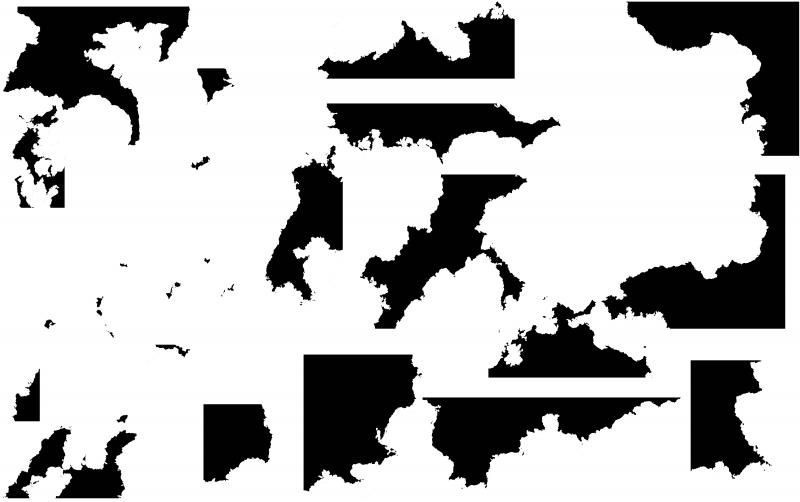
    So I've drawn a basic jigsaw puzzle made out of blob shapes for how all the nations fit together. I found myself returning to Fractal Terrain to make pieces that I thought could work. I'll be posting a WIP once I've got everything settled. For the time being, here's a collection of pieces I thought were particularly attractive.


  7. #7
    Professional Artist Facebook Connected Schwarzkreuz's Avatar
    Join Date
    Oct 2011
    Location
    Leipzig/Berlin
    Posts
    1,636

    Default

    I would love to see your concept sketch in the Way Larb proposed, thats the same Way i reconstructed my Arden Map from 20 years of Story fragments.

  8. #8
    Guild Apprentice Adolon's Avatar
    Join Date
    May 2013
    Location
    Virginia
    Posts
    33

    Default

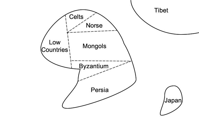
    Here is a reproduction of my concept sketch. It's very, very basic.


    I actually drew it on a piece of paper first. The dashed lines are country borders and I included the various types of cultures I'm going for with my world.

  9. #9
    Professional Artist Facebook Connected Schwarzkreuz's Avatar
    Join Date
    Oct 2011
    Location
    Leipzig/Berlin
    Posts
    1,636

    Default

    Do you lists, of your Material sorted After the countries?

  10. #10
    Guild Apprentice Adolon's Avatar
    Join Date
    May 2013
    Location
    Virginia
    Posts
    33

    Default

    Quote Originally Posted by Schwarzkreuz View Post
    Do you lists, of your Material sorted After the countries?
    What do you mean? Do I have lists for what each country is like?

Page 1 of 2 12 LastLast

Posting Permissions

  • You may not post new threads
  • You may not post replies
  • You may not post attachments
  • You may not edit your posts
  •