Results 1 to 5 of 5

Thread: Urth map

  1. #1

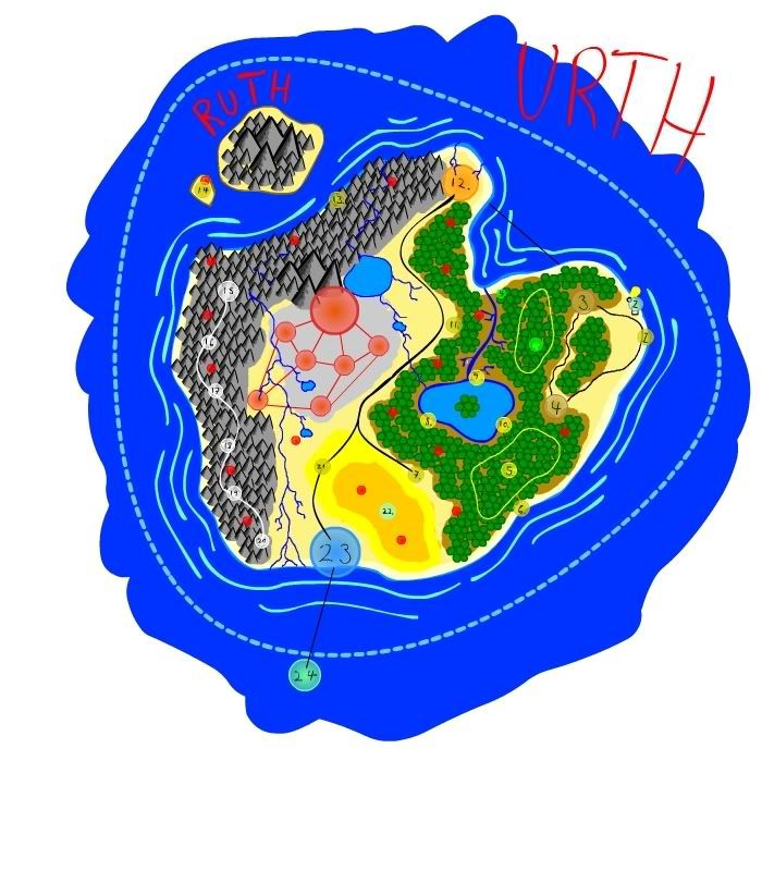
    Map Urth map

    This is my first post and in a way my first map...

    i was looking for a group for a year or so, and found out id found one (almost) so i excitedly bought a blank notebook and started drawing my campaign.

    now ive been playing this campaign for a couple months now and i thought i would do a new hotness version.


    This is a fairly small continent, with a handicap.

    there is a foot deep sand bar stretching for miles around the entire continent (shown here as a dotted blue line) making voyaging impossible...

    now for thousands of years people have gotten used to the idea that travel outside of urth is impossible.

    now that technology is starting to take steady strides, its looking less impossible and more like a reality.

  2. #2
    Community Leader Gandwarf's Avatar
    Join Date
    Jun 2008
    Location
    Netherlands
    Posts
    3,012

    Default

    Nice map you have there. It has a unique look and feel. Have some rep.
    Your rivers are a bit of a mess though. In real life they tend to start in the higher lands and then run into the ocean. You have a lot of rivers that seem to be unconnected or splitting (which isn't natural either). Maybe there is a good reason for this, as it is your world of course...

    Oh, and would only a sand bank really stop voyaging? I am guessing the people have ships? They could launch smaller boats to traverse the sandbanks. They could even build platforms on the sandbanks, disassemble the larger ships and reassemble them on the other side.
    Last edited by Gandwarf; 05-01-2009 at 06:47 AM.
    Check out my City Designer 3 tutorials. See my fantasy (city) maps in this thread.

    Gandwarf has fallen into shadow...

  3. #3
    Community Leader Facebook Connected Steel General's Avatar
    Join Date
    Jun 2008
    Location
    Ft. Wayne, IN
    Posts
    9,530

    Default

    That's a great cartoon-like style.

    Have a blast of 'rep' *bonk*
    My Finished Maps | My Challenge Maps | Still poking around occasionally...

    Unless otherwise stated by me in the post, all work is licensed under a Creative Commons Attribution-Noncommercial 3.0 United States License.


  4. #4
    Community Leader Facebook Connected Ascension's Avatar
    Join Date
    Jun 2008
    Location
    St. Charles, Missouri, United States
    Posts
    8,392

    Post

    Looks like a fun lil map; as to the rivers you have a good one but it is upside down...that one on the far left. Put the branches up in the mountains and have them join up as they move toward the plains to form a single river then flow it to the ocean and put in a small delta if you'd like.
    If the radiance of a thousand suns was to burst at once into the sky, that would be like the splendor of the Mighty One...I am become Death, the Shatterer of worlds.
    -J. Robert Oppenheimer (father of the atom bomb) alluding to The Bhagavad Gita (Chapter 11, Verse 32)


    My Maps ~ My Brushes ~ My Tutorials ~ My Challenge Maps

  5. #5

    Post

    thanks for the comments and rep everyone!

    im going to have to sit down on the rivers and really give them a think...

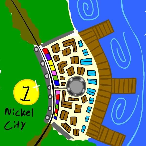
    one thing about the boats though, is there is a town on the south end that has built a dock, specifically for building ships on the deeper water...

    yes a small boat like a canoe could sail, but you wouldnt want to set sail to other worlds in a canoe... or a kyack

    also one last thing about the waters around urth, is that they actually have a very strange current...

    the water moves around in a big circle around urth, moving the water in land...

    anyways heres nickel city the first city map shown on the urth map


Posting Permissions

  • You may not post new threads
  • You may not post replies
  • You may not post attachments
  • You may not edit your posts
  •