

 Reply With Quote
I've renamed the thread for you.


ahh, ok!
that makes sense


I've renamed the thread for you.
My Finished Maps | My Challenge Maps | Still poking around occasionally...
Unless otherwise stated by me in the post, all work is licensed under a Creative Commons Attribution-Noncommercial 3.0 United States License.
Thanks SG! have some rep!
Maybe just reduce the brightness of the glow mapping on the smaller cities or adding a brighter glow around the major city labels would do the trick. I really like this map, though.Originally Posted by tilt

here's the most recent update
finished putting in most of the place names
and started making some custom emblems!
Here's the direct link in case the other one doesn't work
http://img203.imageshack.us/img203/4580/quonand7.jpg
wow... that's a lot of name... you have a big job ahead of you- but looking good
regs tilt
:: My DnD page Encounter Depot free stuff for your game :: My work page Catapult ::
:: Finished Maps :: Competion maps - The Island of Dr. Rorshach ::
:: FREE Tiles - Compasses :: Other Taking a commision - Copyright & Creative Commons ::
Works under CC licence unless mentioned otherwise
The official map of the north coast of Korel has now been released. From the size of Korel compared to Malaz Island, Korel is a very small continent, smaller even than Quon Tali.
Not sure if Sadist is still pressing on with this project, but this can only be of help!
Hopefully Sadist will one day return to the project. In the meantime, here's my own (pretty rubbish) Malazan world map, which is apparently the closest we've got so far to the real thing (the continent shapes and locations are based on a very rough map supplied by Steven Erikson himself).
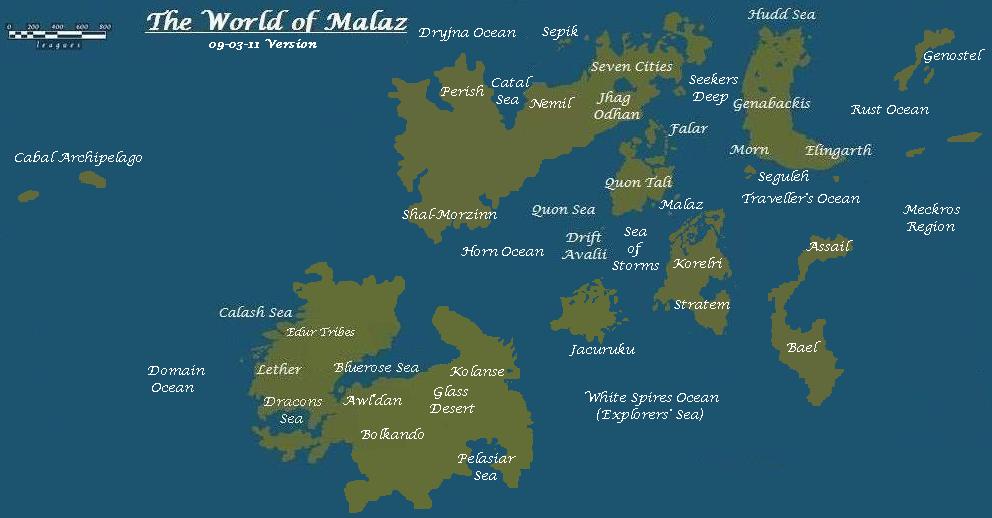
Well do me sideways with a wotsit! For some reason I always had it in my mind that the Lether continent was at a more northerly latitude than Quon Tali, with Seven Cities south of it... duh... Wonder why there's Ice along the equatorial belt. Warren stuff? Omtose Phellack is it that the Jaghut are connected with? Probably why I thought the latitudes were other than they are.
Lovely stuff though. And as for the books, yeah, love them myself but they're like Marmite: if you don't get used to it/them pretty quickly you're likely to think those that have are a bit mad.

Prod and pull. And a nice map in your own right!


