Welcome, and I agree, a very lovely, lovely map.

Welcome, and I agree, a very lovely, lovely map.
Daniel the Neon Knight: Campaign Cartographer User
Never use a big word when a diminutive one will suffice!
Any questions on CC3? Post them with CC3 in the Subject Line!
MY 'FAMOUS' CC3 MAPS: Thunderspire; Pyramid of Shadows; King of the Trollhaunt Warrens; Demon Queen's Enclave


Great map Quindia, I had almost forgotten about you. I dropped by your site several years ago and had exchanged emails.
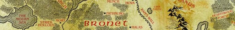
For the rest of you in the guild, you can check out the evolution of the map through several versions at http://www.quindia.com/where.html (bottom right links). I always found it fascinating to see drawings first done in elementary or middle school change over time and several iterations into the incredible work of art that the Quindia map is now.
Although the site hasn't been updated in awhile, I hope Quindia you add the 2008 version to the listing of maps. You just keep getting better and better.
I also hope you put up more city maps (and possibly locale maps) like Crowyn (at http://www.quindia.com/crowynmap.html --reminds me somewhat of Harn city maps). Thanks again and welcome to the guild.
Last edited by thebax2k; 02-25-2008 at 11:06 AM.
Twenty-eight years of work on a map... That kind of crazy is inspiring.
Last edited by rlucci; 02-25-2008 at 01:09 AM.
Thanks, folks!
The map was created in CorelDraw and the textures added in CorelPaint. The best thing about this map is that it is a vector file and 100% editable and scalable. When boundaries change during the course of the campaign (as you'll see if you follow Bax's links) I can change things at will.
The style of the line art is based off the original Tolkien maps, but the colors are inspired by the more modern map designed for the movie. I actually have a version on a plain white background with bright red text that mimics the old school map.
Although created completely in the computer, I tried to achieve a hand drawn look. The mountains are vector images, but each one is rendered individually, as are the hills, trees, etc. They are all drawn with a Wacom tablet using a stylus.
Each feature - mountains, hills, forests, text, etc. - is on a separate layer so I can edit each one without having to work around the others. As an unforseen bonus due to the way the map was constructed, I now have a virtual library of custom "clipart" I can use to duplicate this look in a fraction of the time it took to create it in the first place. There is another continent that I have run games in and it will be rendered in the same style.
I do indeed plan to update the website for 4e. It has been years since I touched it, but I am actually planning to completely redesign it which of course means more maps.
I'll head over to the intro section to add a little more. Thanks for the welcome and if I can answer any specific questions about the map, I'll be happy to.
Last edited by quindia; 02-25-2008 at 07:36 AM.
Welcome Quindia. I love the map. The look is really cool. Its kinda Pete Fenlon meets grunge but everything is clearly set out and informative, not to mention artistic and eye-catching. My favourite aspect of the map however is that its a sort of chart of the history of gaming. You've worked on its so long that the landmarks are often landmarks in gaming history, that bring back some great memories. Its clear how you've managed to incorporate some famous products and flagship adventures as well as literary favouritesinto your own campaign world.
Places like White Plume Mountain, Dearthwood, Marzabul, the Borderlands and Charn come to mind. I love the map because its not sterile and contrived, its testimony to many hours of great gaming.
Well done.
Torq
The internet! It\'ll never catch on.
Software Used: Terranoise, Wilbur, Terragen, The Gimp, Inkscape, Mojoworld
I've designed lots of different game worlds because I love drawing maps (hence the reason I joined the forum), but I always keep coming back to Quindia. Some of the places have names that a goofy ten year old would come up with (the city of Frodo), but I can't bear to change them now.
Some of the iconic additions came during the years when I dropped a ready made adventure into a game and they stayed part of the campaign world. Others names, like Haven, have been used in many different worlds. A few others are purposely generic (the Black Forest) to invoke a nostalgic sense of mystery such a place would have held when I first started playing D&D.
The overall effect is that the world has a familiar feel even for people who see it for the first time. The games I've run over the years have shaped the world (the fifth ring was once whole, Ram's Wall was built by a player, Gornath was once the capitol of an empire).
I'll post some of my other maps here soon, but none have the history of the Realm of Quindia.
If only I had kept updating the same map over my years of gaming...
I always seemed to scratch and start from new.
Really nice maps.

Compelling job! I love it!Originally Posted by quindia

Only a question: do you think you would obtain the same beautiful result using a different professional sw? For ex. Photoshop?
I don't use Corel, so I'm asking if there's something I can't do with Photoshop...
U often use photoshop as well because the pressure sensitive tools work amazing well with the Wacom. I could certainly get the same results, but the utility of the map would be reduced for several reasons.
1. While the layers method would work perfectly well in photoshop, in my map each mountain, tree, and hill is an individual (and editable) object. I can move, resize, flip, etc. every single object.
2. The vector map is scalable. I can reduce or enlarge portions, crop out sections to use as the basis for more detail, and alter line widths and the like to maintain the aesthetics. In photoshop, you can certainly resample the image and crop it, but you will be stuck with the line widths when you zoom in.
3. My original map in the computer is 24x30". I had it printed on canvas and it hangs in a frame on the wall of my game room. I designed at that scale for that reason. I have a hi-res jpeg at that size stored on the computer, but it runs somewhere in the neighborhood of 12Mb as a flattened image. I would hate to use that file as my working one with the ten or twelve layers I have in the CorelDraw file!
Clarence, your comments on this are well said, although I believe that only #2 is really an insurmountable issue: PS, by its nature, does not allow scaling and such to the nth degree (it's not vector, but raster.) If this were of interest to me as a cartographer, I would create the image in Adobe Illustrator--which is vector--and then only do final touch ups in Photoshop. The two programs work so well together. Corel's a great program--and as is shown here, very powerful!--but the Adobe apps could collectively do the same. It's a common mantra here at the Guild, well supported by hundreds of maps, that the program is not as important as the user.Wouldn't you agree, Clarence?
Don
My gallery is here
__________________________________________________ _______
"Keep your mind in hell, but despair not." --Saint Silouan [1866-1938]
 Posting Permissions

 Reply With Quote