Hello All, Name's Sinphanius. Building a Planet I am, and thought I would share my journey with the people here, something tells me they might find it interesting. Not quite sure what, just a hunch, probably wrong...
So, I have decided to structure this thread around 7 Major posts, the 'Days of Creation' of the Planet Sargos. I am mapping out the entire Earth-Like but slightly warmer and drier planet Sargos during this time, some of it is done, but a lot is still left to be done. I am currently revisiting the terrain of the planet. I already have most of it mapped out, and was mapping climates out, but I decided to change some things and so I'm back to Terrain.
To start with, I am using the following pieces of software, for the following Evil Porpoises;
Fractal Terrains Pro 3 + Wilbur: Most of the Terrain and Climate Mapping was done in FTPro3. Wilbur is being used for erosion mapping maybe.
Photoshop CS5: Conceptual Mapping.
Paint.Net: Image Reduction, Cropping, and Selection.
Illustrator CS5: Later Mapping steps, specifically maps dealing with populations, like Species Proliferation and Culture.
Google Earth: Going to be using it possibly maybe.
Speaking of Which; some Background. This isn't just an idle Mapping exercise, there is a purpose for this. Specifically, me and a friend of mine are setting up an online Forum based Nation Centric RPG, where players will take control of political factions and try to chart out the History of the Planet. We decided to start off at the Bronze Age and work our way up to whenever we get bored, but then decided that using Earth would be boring, so we decided, why not build our own custom planet, complete with alien species and the like.
Also lets throw in functional magic so we can develop the species into a Spacefaring Magitek Galactic Empire, why not?
How hard could it be?
Well, Sargos is the planet that game will be set on, and our alien Species, the Trical, are our species of Rubber Forehead Aliens. They are meant to be a relatable near-human substitute, and although they do have some VERY big differences between them and humans, at least two of which may radically alter their social structure compared to humanity, these differences are primarily cosmetic.
But that is another story and shall be told another time (SEE: Day 7).
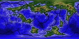
So, this first post is a general overview, and my first steps towards the creation of this planet. Specifically, this post will consist of the initial genesis, just a random FTPro 3 map, and then me applying Plate Tectonics to it.
So first things first, this is the original randomly generated map;
Settings:
Code:
Fractal Function: Wilbur Ridged Multifractal
Highest Peak: +30000 feet
Lowest Depth: -30000 feet
Circumference: 25118 miles
World Seed: 1578186171
Roughness: 0.75
Percentage Sea: 70
Land Size : 2.65
Continental Shelves at -999.999 feet
Now, I plan for the planet to have vastly less water coverage, probably around 45-50% as opposed to the more Earth-Like 70%. After all, this planet has a bit warmer of a sun and their core/mantle is also slightly warmer due to... factors... as will be reflected when I start charting out Temperatures. However, I put the water coverage high for a reason. Specifically, FTPro 3 has a problem with putting Mountains in the right spot for a Continent. It tends to put them in the middle, whereas they generally go to one side in reality due to the way Plate Tectonics work. Most of the tutorials I have seen suggest that you flatten the existing mountains and then rebuild them on one of the sides of the continent, I decided to do THE EXACT OPPOSITE!***
By putting the water coverage so high, I can now build the continents wherever I want but still have randomly generated Mountain Ranges. This means I can keep the fancy mountains while building the continents however I want. Giving me the best of both worlds, one I built from scratch and one that was randomly generamated. This is very useful as I already had the general layout planned out before I saw this arrangement.
I'm going for a planet that is just barely coming out of a Super-Continental Phase. The Supercontinent has already split half way, with a large Ocean openning between two large Landmasses, however these landmasses are actually still connected, with that connection currently diverging, creating a nice long rift valley that just happens to widen into a proper ocean after a while.
Beyond that, this planet's tectonics are a bit more active than Earth's. For instance, where Earth has 7 Primary and 8 Secondary Plates, this planet has 11 Primary Planets and a further 14 Secondary ones, and don't get me started on the Tertiary Adjun- I mean Plates. I didn't map out the Tertiary Plates, just take my word for it, there's a lot of them. (I'll map them out later so I can have a good idea where Earthquakes and Volcanos are)
So without further ado, here is a map of the Primary and Secondary Tectonic Plates:
The Dashed Lines are points where the Plate is splitting. Remember, Ending Supercontinental Phase. I think I have a pretty good variation in the size of the Plates. With the Arctic Plate being the largest, although it is splitting, so it won't have that honor for long*.
On its own, not very interesting, so lets combine it with some Directional Vectors** and other motion Indicators!
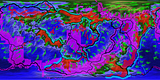
Far more fun, look at all of the pretty colors!
Speaking of Colors:
Green Arrows = Movement Direction of the Plates (Despite/As Previously/Postly Stated/Footnoted, not actualy Vectors)
Purple/Pink = Divergent Boundaries
Red = Areas of Uplift
Blue/Teal = Subduction Boundaries
First off, I mapped a rough circuit of Divergent Faults. If you look at a map of Earth, the Divergent Boundaries do make a rough but incomplete circuit around the planet, essentially lapping Antarctica with a fault splitting off to go up and be the Mid-Atlantic Trench. This planet has a bit more Divergent Boundaries because of all of the splitting going on in the former Supercontinent, which has started up while the Divergence from the previous Ocean is still going on, at least a little bit. It is slowing, but hasn't quite stopped yet.
From there, I mapped out the Movement Vectors, occasionally changing the location of the Divergence Boundaries as I update the core Movement Vectors. And lastly, I mapped out the Subduction Zones, with an eye towards creating interesting geologic features. For instance, the Tectonic Plate that's surrounded by Mountains (around 60-West and 30-North) is actually sinking into the Mantle while Torque is tearing the northern portion of the Plate away from the Southern Portion, conversely, the plate directly to the east is just sinking outright.
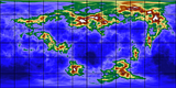
And now for some bonus Maps, the Tectonic Situation around the North and South Poles. I have no idea why, but FT3 does Not like my translucent .png files, and adds random splotches of color where they have no business being.
North Pole;
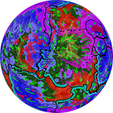
South Pole;
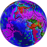
There is a reason for the Scrunchiness of the South Pole and the Radiatingness of the North Pole. Remember that Functional Magic I talked about? Well it includes a Leyline/Nexus Network, which in many ways mirrors the Electromagnetic Field of the Planet. This, combined with the Cosmic Manaian Weave creates a psuedo-physical force at the poles, pulling the Mantle 'Up' in the North and 'Down' In the South.
And no, that totally isn't a retoractive justification for the way the Polar Plates just hapenned to turn out, why would you suggest such a silly thing.
Okay so maybe it was, but I'll admit the focus of the Tectonics was simply because I was trying to create a situation where the amount of uplift was roughly equal to the amount of subsidence, and I think I succeeded. I also succeeded in creating a planet with roughly 2.44 ****e Tonnes of Mountain Ranges. Like seriously. Mountains, lots of em. Everywhere.
And now that that is not the case anymore, never mind.
Speaking of which;
*In Geologic Terms.
**Not actually, technically, in the strictest sense, Vectors.
***Doctor this is Madness, We're Pulling your Funding!****
****Cookie for anyone who knows who I'm quoting and from where.
As you can see, I tend to write a lot, expect these posts to get veeerrrrrrry long.


 Reply With Quote