Page 1 of 2 12 LastLast
Results 1 to 10 of 13

Thread: Geldonion - World Map

  1. #1

    Default Geldonion - World Map

    Hello all, this here is the world map to my fantasy conworld Geldonion. The program I use is AutoRealm, and while far from ideal it was free and gets the job done. In the program, the map is much more detailed in that there is a lot of names of things and you can see the cities, though the majority of them are yet to be named as I have yet to construct the languages that I would use. So far I'v only constructed the Dwarven language, but I still have to edit those names too because I didn't keep up with the map when I was finishing the language.

    This is the northern continent, and when I'm completely done with this one I will move on to the southern one. I still have to add many things, particularly all the cities in the east, more islands, details for the islands I have, and names for mostly everything, as I have mentioned.

    This program was actually really frustrating when trying to convert the file to a large zoom-able image, and it's really not too pretty. Any alternative program suggestions would be great.

    Feedback as well; All is welcome, though I am particularly concerned with the originality of the continent and even distribution of geographical features. I'll be happy to answer any questions

    Last edited by Delvestius; 10-31-2012 at 09:57 PM.

  2. #2
    Guild Master Facebook Connected jtougas's Avatar
    Join Date
    Sep 2010
    Location
    Wales Massachusetts
    Posts
    2,813
    Blog Entries
    27

    Default

    It looks very good. (I'd LOVE to be able to zoom in and get a closer look) I actually have Autorealm and was not aware that it could output maps of this type. The continent looks great ( I especially like the islands at the mouth of the large Southern Bay) Without being able to zoom in and get a closer look I can't really offer any constructive feedback. All I can really say is keep up the good work and have some rep
    I am the breath of Dragons...The Song of Mountains...The Stories of Rivers....The Heart of Cities.... I am A Cartographer....

    Finished Maps
    Kingdom Of Shendenflar Campaign Setting (WIP)

    Everything I post is free for use and redistribution under the Creative Commons Attribution-Noncommercial-Share Alike 3.0 licence, except where noted otherwise in the thread.

  3. #3

    Default

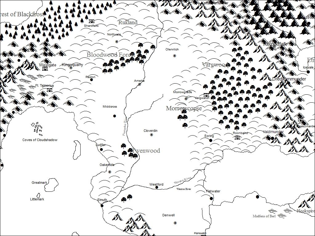
    Thanks! Yeh, it don't think it's really meant for this kind of stuff, which is probably why it's so difficult to convert... Here's a closeup of Talmorion, which is probably the most developed part of the map so far -


  4. #4
    Guild Master Facebook Connected jtougas's Avatar
    Join Date
    Sep 2010
    Location
    Wales Massachusetts
    Posts
    2,813
    Blog Entries
    27

    Default

    I'd have to say it looks very good. There are a couple of issues that you could fix. 1. Some of the text is hidden behind symbols the "Bloodwood Forest" most noticeably. 2. Some of your mountain symbols "hang off" the end of your landmass ( a minor thing but noticeable) Overall this is very good. Do you plan to color it? (I think a desaturated palette would look best with this style of map)
    I am the breath of Dragons...The Song of Mountains...The Stories of Rivers....The Heart of Cities.... I am A Cartographer....

    Finished Maps
    Kingdom Of Shendenflar Campaign Setting (WIP)

    Everything I post is free for use and redistribution under the Creative Commons Attribution-Noncommercial-Share Alike 3.0 licence, except where noted otherwise in the thread.

  5. #5

    Default

    At this point, I'm interested in making it look legit, which would require a better program. This was basically just a means to digitilize but now that I have most of the geography down I wouldn't mind upgrading to a program that's more inclined to this type of work. The issues you mentioned were annoying at first, but it got to the point where it was way too tedious to fix over and over again and I just stopped caring because I decided it was a rough draft. Honestly, I should of looked harder for a better program from the start, but at any rate that's my plan now. I would probably be interested in fully coloring it eventually, in a style that was represented very realistically (such as these- examples) but the next step is making a version that is easily printable, like the maps of Westeros and Middle Earth in their respective books. Any suggestions as to free (or relatively cheap) programs that I can get started with?
    Last edited by Delvestius; 10-31-2012 at 10:27 PM.

  6. #6
    Guild Master Facebook Connected jtougas's Avatar
    Join Date
    Sep 2010
    Location
    Wales Massachusetts
    Posts
    2,813
    Blog Entries
    27

    Default

    I can highly recommend GIMP as a great image editing software. It is very powerful and has a lot of features that can make mapping a lot easier ( I use it almost exclusively) There are a lot of tutorials here that detail techniques that you can do with GIMP as well. The best part is it's FREE.
    I am the breath of Dragons...The Song of Mountains...The Stories of Rivers....The Heart of Cities.... I am A Cartographer....

    Finished Maps
    Kingdom Of Shendenflar Campaign Setting (WIP)

    Everything I post is free for use and redistribution under the Creative Commons Attribution-Noncommercial-Share Alike 3.0 licence, except where noted otherwise in the thread.

  7. #7

    Default

    Nice! Download started

  8. #8
    Software Dev/Rep Hai-Etlik's Avatar
    Join Date
    May 2009
    Location
    48° 28′ N 123° 8′ W
    Posts
    1,333
    Blog Entries
    1

    Default

    I find Inkscape is very good for this style of map. I used it for this map for instance.

    Also, you appear to have quite a few diverging rivers.

  9. #9

    Default

    The only time rivers diverge is at coastal deltas. All other rivers are convergent ones.

  10. #10
    Guild Expert jbgibson's Avatar
    Join Date
    Oct 2009
    Location
    Alabama, USA
    Posts
    1,429

    Default

    Another boost to plausibility would be to fix the big lake - like how rivers tend not to diverge (there being only one way 'down' from any point on a watercourse) - a lake will have only one outflow (only one point on the shore would be lowest). If by chance two points were almost the same height, it would be temporary, only til one washed a bit deeper, and then that deeper one would capture more and more of the flow, once again leaving but one outflow. Lakes of course can have multiple inputs.

    The 'look' is great.

Page 1 of 2 12 LastLast

Posting Permissions

  • You may not post new threads
  • You may not post replies
  • You may not post attachments
  • You may not edit your posts
  •