Reply With Quote
first I'd like to say WOOT First comment
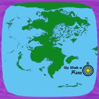
Earth inspired of course but thats fine by me, interestingly fantastical shaped islands and such. in general it's a pretty cool map


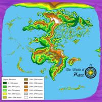
Hi, I'm new to these forums and looking for some constructive criticism for my work. Right now I'm still ironing out the landmass shapes before I start working on mountains, lakes, rivers, regions, climates, etc, and it would be nice if I could get some feedback before I move on to the next few steps.
I'm still not really sold on the layout - I want it to be reminiscent of earth, but only subtly. I don't want the similarities to be immediately obvious (at least, not so obvious that it comes as a turn-off to those looking at the map), but I'm loath to make any more major changes to the upper continents. The southernmost continent is what I'm currently considering changing, but I'm open to suggestions for other areas as well.
The tools I'm using to make this map are Photoshop, a mouse, and google (for reference maps). I also have a trial version of Fractal Terrains that I'm going to have available for another week or so, that I'm going to use to generate generic shapes for lakes (just as a creativity aid). After it expires I'll hunt around for some free fractal generators for the same purpose.
Last edited by Seiun; 06-03-2008 at 08:47 PM. Reason: Adding detail about tools used
first I'd like to say WOOT First comment
Earth inspired of course but thats fine by me, interestingly fantastical shaped islands and such. in general it's a pretty cool map
"The Enemy's Gate Is Down" - Ender Wiggen, Ender's Game, Orson Scott Card
Software Used- ME v16, My Hands 1.0, My Brain
All Maps are either Copyright J.L.Odom and Bardic Fire Studios or under the Creative Commons Attribution-Share Alike 3.0 United States License (Note it applies to all countries even though it's United States)
Pretty nice. My only critisism is the land mass to the far right. I generally don't like landmasses on world maps that are just barely shown. I would either expand the map to map the entire world's land or shrink it up. It looks like you might JUST be able to shrink it an inch over to the left and get rid of the new land while still keeping the northern continent fully in view. Again, just my opinion...
Also, it would be helpful to know what tools you are using the create your maps as many of the specific comments and suggestions may be usable only by a specific type of software.
Joe
My Finished Maps
Works in Progress(or abandoned tests)
My Tutorials:
Explanation of Layer Masks in GIMP
How to create ISO Mountains in GIMP/PS using the Smudge tool
----------------------------------------------------------
Unless otherwise stated by me in the post, all work is licensed under a Creative Commons Attribution-Noncommercial 3.0 United States License.
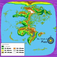
The purple cloud surrounding the map is not just for show - it's an actual map feature. Only one hemisphere of the map is shown because the other is off limits - magically sealed in order to allow it to heal from a catastrophic magical war that took place long before the birth of mankind, and those purple clouds are a ring of storms that literally prevent travel to the other side, both through physical and magical means.Originally Posted by jfrazierjr

With such a ring of storms bisecting the planet, I figured that it would be too "artificial" for all the visible landmasses to be entirely in this hemisphere, with nothing overlapping the storms. I'll admit I'm trying to strike a delicate balance between realism and aesthetics, so I'll see what other people have to say on the subject.
Also, thanks to Arkkeeper for your encouragement!
Cool idea... as long as you have a reason for it. BTW, I don't think it's immediately apparent that this is based on earth. The lower continent does fairly quickly bring Africa to mind, but I think it looks nice the way it is.
heh... the shape of the purple makes it look like an old TV tube with the rest of the map as the image...
Joe
My Finished Maps
Works in Progress(or abandoned tests)
My Tutorials:
Explanation of Layer Masks in GIMP
How to create ISO Mountains in GIMP/PS using the Smudge tool
----------------------------------------------------------
Unless otherwise stated by me in the post, all work is licensed under a Creative Commons Attribution-Noncommercial 3.0 United States License.
All I can say is... That's a lot of islands! Particularly in the "Indian Sea" region... (the map almost looks like it took earth's Eurasia and Africa and then completely obliterated India and the mideast until nothing but islands remained). Nothing wrong with this, though, particularly given your "catastrophic magical war " explanation.
Pretty Cool, I would almost say it is just coming out from the Pangea landmass. I can't wait to see some regional maps!


I'd really like to know what was the technique you used to make this map as I'm trying to achieve similar results, i. e., Earth-like geomorphology. Other than that I'm fairly itching to do a tectonic analysis of this world, if you don't mind, that is.
A trap of space-time topology would come to mind, I mean, the division could be achieved by a wormhole of sorts girdling the planet and transporting foolhardy sailors or travelers to the antipodes of their location on their side of the barrier; the same for whatever like-minded nasty things existed on the other side. I remember something similar in Gordon Dickson's Time Storm though people traversing the barriers were transported in time instead of space.
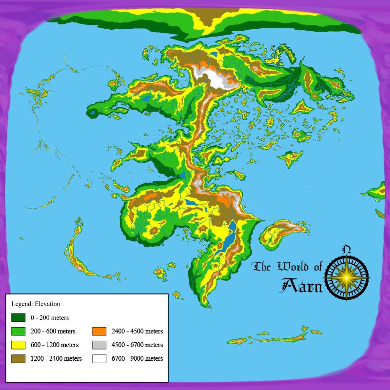
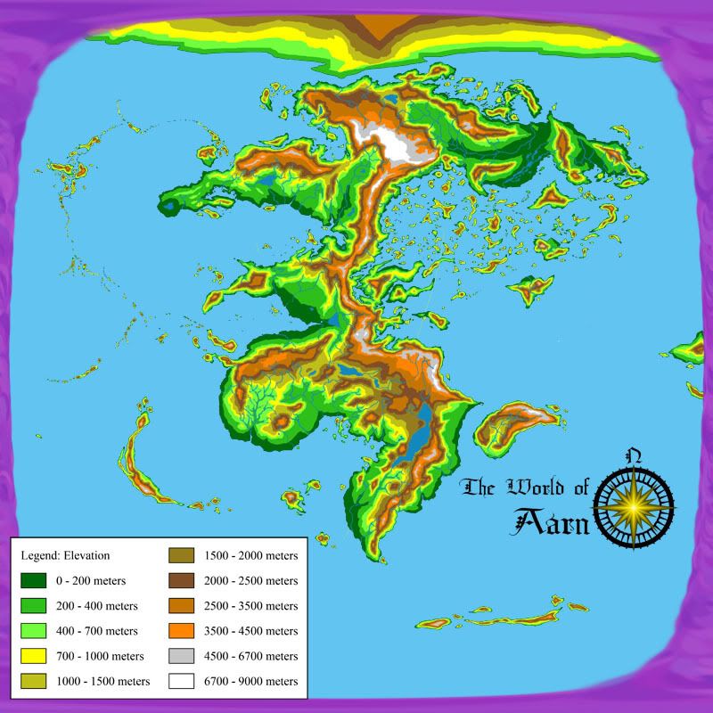
I think the only thing that detracts from this is the polar continent: it stands out by being far less detailed than the other land masses.
Nevertheless keep up the good work.
"Truth is stranger than fiction, but it is because fiction is obliged to stick to possibilities, truth isn't."
-- Samuel Langhorne Clemens a.k.a. Mark Twain. (1897) Following the Equator.
I've actually been trying to keep the tectonic layout of the world in mind while designing everything, so I wouldn't mind at all! It would be interesting to see how closely my idea of the tectonic shapes matches up with yours.
As for the layout, pretty much the only thing I used was loads, and loads of reference images. It's all hand-drawn using a mouse (and now using a tablet I just purchased.)
Because I'm using a rectangular projection for the map, things naturally become less and less detailed the farther north/south you go, so that's more an artifact from the map projection than the coastline layout, but I'll certainly keep that in mind.
On to other things, though...
I've been doing a lot of work on the map over the weekend, and I've thrown together two rough images for some topography and lake/river layouts. I'm leaning towards the less detailed one, mostly because when hand-drawing something, the more details you include, the more things you can wind up getting wrong. Less can be more, and allow something to appear more detailed because the mind fills in the blanks. The less detailed topography would also give me more leeway for re-drawing the lakes and rivers, many of which I'm currently not happy with at all.
Also, for the record, these are only 800x800 because that's the most photobucket can allow. Once I figure out how to attach these to my post, I'll do so like that at a higher resolution - My work copies are 4000x4000 (approximately 5 kilometers per pixel)
Any thoughts?
When you do a simple reply, there is a "Go Advanced" button. This opens more options further below the text area field where you type your comments. One of these is a button named "Manage Attachments". Clicking on this button will open a popup window (which means you have to make sure any blocking software lets it open) that will allow you to upload files in multiple formats up to certain sizes (depending on the file type.) jpeg and png files will auto-magically get converted to inline thumbnail images which click out to the larger version. With a resolution that large, you "may" have to reduce the image quality of jpg files to be able to get it under the file size limit when saving from your graphic application though.
Joe
My Finished Maps
Works in Progress(or abandoned tests)
My Tutorials:
Explanation of Layer Masks in GIMP
How to create ISO Mountains in GIMP/PS using the Smudge tool
----------------------------------------------------------
Unless otherwise stated by me in the post, all work is licensed under a Creative Commons Attribution-Noncommercial 3.0 United States License.
 Posting Permissions