No I think your right, but that's all I could think of. Thats when I started getting discouraged. I really don't think its right, but I think maybe I'm close. Not sure.


No I think your right, but that's all I could think of. Thats when I started getting discouraged. I really don't think its right, but I think maybe I'm close. Not sure.
Some quick considerations about plates
- You have 2 kinds of plates, continental (less dense) and oceanic (more dense)
- Plates can rotate, translate and deform (Larger plates are less likely to rotate than smaller ones)
- When two plates collide the outcome depends (amongst many other things) on their density. More dense plates will subdue under the less dense ones forming a trench and a mountain range.
- A plate colliding on one side is probably creating crust on the other side.
I see some problems:
You have an oceanic plate that's moving towards all directions. Plates can really dilate, but usually not a big plate such as that one, and not enough to be relevant here.
You lack the small plates, that usually are formed after the fragmentation of bigger plates. Look for the pointy edges of the large plates and fragment those off, as that's usually what would have happened.
Your plates are moving really antagonistically everywhere, that's probably not impossible, but most uncommon. You continent will be riddled with earthquakes, tsunamis and volcanoes. Usually there's a lot of plates frictioning laterally.
Take earth's plates as an example:
http://education.sdsc.edu/optiputer/...lateArrows.htm
And this are possible plate interaction outputs:
File:Tectonic plate boundaries.png - Wikipedia, the free encyclopedia
Last edited by rgcalsaverini; 01-22-2014 at 03:19 PM.
I dont know much about tectonics, and I have only 5 minutes before I have to go, so there will probably be a lot of mistakes on my examples bellow, (take that as a great learning opportunity lol) but what I what I usually do is:
- First of all, determine where your continents are separating and where you are creating crust. Look for big archipelagos and separated landmasses. Then look for landmasses that might be colliding. This is my (quick and probably wrong) guess:
- From there you can devise some majos plates and estimate their movements, this is my (quick and probably wrong) guess:
Then usually you have to makea few corrections to the map. For example, the place marked as #1 the map might have island formations.
- Fraction the plates under the most stress, usually at the pointy edges, propagate the implications of that to the map.
PS: A bigger number of plates, and more carefully thought ones, will make more sense and produce a better map. That up there was just a rough example of how it works.
PS2: I'll revisit this thread when I get back home and to things more carefully.
Last edited by rgcalsaverini; 01-22-2014 at 03:59 PM.

Slightly off topic at this juncture, but here is a real nice website that takes a look at the ITCZ and basic weather patterns.
http://www2.palomar.edu/users/pdeen/...weatherpat.swf
Another thing with your tectonics, aside from the already stated, is that you tend to have your land masses sitting on a single plate, with very little land to land collision... not impossible, for certain. But it does leave out some "drama" to the whole thing, LOL. And land masses isolated in the middle of plates can become barren over the millennia, as volcanic activity helps promote fertility in the soil. Australia is an example, where even with ample rainfall in areas, the land can still be desert-like. But that's really here nor there, just babbling by now, LOL.
When looking at currents, note that on Earth there is the east-west equatorial current, there are also counter currents. Not a huge deal, might be worth noting.
Upon the Creation of the World the First Dragons cast their seed in the light of a Sun and a Thousand Suns, beneath the Moon and a Thousand Moons, on a World and a Thousand Worlds.
www.sistercontinents.com
Ok. I think I'm on the right path here. This is not finished, its just all I could get done before bed. I have most of the major zones squared away, and if there is anything else that needs to be tweaked, I can do that before I finish up in the morning. I hope you will agree that this attempt is much closer to right so far. Thanks again for all the help so far. Certainly could not have gotten this far on my own. Once this is straight, I'll be able to map out my mountains and then I should be able to get a good grasp on my climate zones.

Oh, now I like it! Its very believable, but I still think that you should add a small plate or two
Another thing to consider is for how long some tectonic movement trend have been going on, and how fast it happened. For example, depending on how things played out, you should dot some divergent boundaries with a few islands, since those can have pretty mad vulcanism. Like the point where you have three plates diverging, that's a good candidate!
My little 2 cents for climate is to divide and conquer. Trying to place all the climates at once can be very confusing, usually at first I separate the maps into Very cold, Cold, Mild, Warm, Hot and Very dry, dry, wet, very wet, and from that I work out actual climate zones.
Just some pointers that you might already seen, with all the material you got:
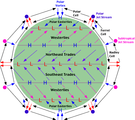
On earth-like planets winds blow like this:
Factors that increase humidity:
Wind blowing from the ocean into the continent.
Wind blowing into mountains (orographic rains)
Heating of air in general, such as locations at the equator or the tropics (+- 60º). When the air heats it goes up, and looses its carried water in the process.
Factors that decrease humidity:
Strong dry winds.
Cold currents.
Being on the other side of the mountain.
Cooling of air in general.
A good reference material:
7(p) Global Scale Circulation of the Atmosphere
Pixie's rules of thumb are probably good enough to get a plausible set of circulation going. But to get a really interesting set of winds and waves, you may want to first figure gross overall seasonal air circulation. As best I understand, a main driver for surface currents is the prevailing winds across a stretch of water. That gets modified of course if winds would seem to pile up water in one corner of an ocean basin - then you get currents just to 'relieve the pressure'. Plus, the ocean currents will tend to stick around once set up - most stay stable, with a few odd seasonal oscillations or even reversals.
I am not a climatologist (!) but take a look at the kind of figuring I've suggested & others have suggested in this post. If it seems too complex, ditch it. If it seems like fuuUUUuunn, though......
About the island chain... how about if instead of a subduction zone ring-of-fire thing, you had a *really* energetic hotspot going? You know how the Hawaiian arc apparently developed as the Pacific plate passed over upwelling magma: littler islands older, as they have eroded (or the hot spot has been strengthening), biggest still all nice and lava-splashy, Kilauea-like. In the mood for some serious volcanic activity? The plate under the arc would need to be moving perpendicular to what would form subduction islands.
Ok. So this is my plates done. I think.I may have goofed up the last half. There may be to many small ones. There may be to much conversion and diversion still, or some of the transform faults may be wonky, etc. But I think it is right. Here is the final tectonic map.
Assuming this is right, I'm going to sketch out some orogeny zones (almost sounds sexy... and maybe to the geographer it is
As a final note for the evening, my eye keeps drifting to the huge expanse of water to the west of the map and wanting to fill it with something. Should I, or should I leave it alone?
I think it looks pretty natural to have a huge expanse of water in the ocean

Oh, but you have a thing there already - it is a churning, storm-wracked, endless expanse of vicious nautical adversary for any sailor who might dare to sail west. Here be sea serpents. If you have navigators who *can* brave its terrors, they will be heroic, or else require extensive fleets and preparations. If your era turns more modern, the expanse will call for endurance in air transport - zeppelins and seaplanes perhaps.
It's the biggest thing on your globe - though it has a visual sameness, don't think of it as nothingness, but as a magnificent, malevolent feature that can lead to great storytelling.
 Posting Permissions

 Reply With Quote