Reply With Quote
It looks really good and clean Vorro.
There probably isn't a 'dated' style of mountains that wouldn't somehow take a long time to do.
I look forward to seeing whatever you decide to do.


A very clean and efficient style! Even if i liked your old Elyden maps a lot more, this is still a very good looking map. It does feel very modern but then again the 1900 are quite modernAnd count me in as someone who's not a fan of caterpillars as well (though probably for very different reasons
).
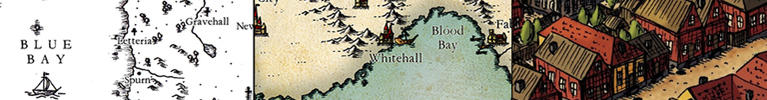
I love the symbology, btw. Gives it a lot of "character".
I'm trapped in Darkness,
Still I reach out for the Stars
It looks really good and clean Vorro.
There probably isn't a 'dated' style of mountains that wouldn't somehow take a long time to do.
I look forward to seeing whatever you decide to do.
Artstation - | - Buy Me a Kofi
I'm thinking of a greyscale topography style, using something simple (like from the Saderan tutorial) and see how that works.
in the meantime I've spent most of the day updating the labels on the map to correspond with the key that I've been working on:
Still quite a few things left to add but I think it's a pretty good basis for the map.


What's the difference between a political border and an international border?
I think that 36 symbols just for cities/villages is way too much.
It looks very good, I love your care for details! I kinda agree with Azelor about the numerous cities's symbols, though.
Why are you trying to tell me the city population on a map?
Beside the heirarchy is...
Village = Around 300 people
Town = Around 2,000 people
City = Around 20,000 people
Large City = Around 100-200,000 people but changes with the era and what is considered a city... Athens which has like no defined borders was considered to have like 500,000 (forgetting the slaves which made it in the millions), but that wouldn't be considered part of the city today.
Major City = Around 500,000 to 1,000,000 people
Villages you generally can leave off because they exist at 2-3km intervals
Towns exist roughly at 30-50km intervals
Cities of all sorts are roughly 100km intervals. Large cities and major cities are important which is why they grow so big where as regular cities are more or less just another layer of markets.
So you only really need to disinguish Towns, Cities, and Capitals imo... the rest is just information that no ones going to look at or for in most cases... That's what i think anyways.
Amazing work, as always, Vorro. Could go on for some time babbling on about what I love about your work.
Concerning the labels I for one love the level of detail. Sure, on a regular fantasy map that would seem like a lot. Sure, on a regular map, it would be a lot. However, this is no regular map. With all the extensive lore you are building, with the right knowledge, such a detailed map would probably be a blessing. I mean, this kind of huge map would never work in a regular novel, but in a atlas over a fantasy world sure why not. And recalling any fantasy-world ever, villages tend to have a bigger role then in our world. I mean, this is supposed to be complex, right? Wouldn't it be awesome to see this kind of information in a Middle Earth map? I think so anyway
Keep up the good work!
Cheers,
tainotim
While much of that may be true, relative to Earth and its history, this is another world, so it need not be so here.Originally Posted by Durakken

And Vorro, having created the world, would be the one determining what was important to the task of mapping it, I would think.
This is an atlas, not just one mere map. Atlases contain all sorts of information that goes well beyond a simple map.
An atlas may contain maps at different scales and as such more information and distinction of that information may be required.
So there's like, 5 cents worth.
I like the distinction between city and fortified city. I've done some similar things with city elements in the past.
I applaud your thoroughness Vorro. I would think though that you could show the city icons and then just the 3 colors to denote those differences without 36 icons but then you might have to use words to explain which may not be as efficient as the colored icons.
Artstation - | - Buy Me a Kofi
The terms themselves are subject to change, though the gist is the former isn't necessarily a different country (it might be a vassal or slave-state), and the latter would be. So for instance a twin nation would have an 'international border' going around the circumference of both as a whole (so no black line between them) but there would be a thick purple line dividing them from each other. I did pinch these from some atlases that I've been using for reference so it's not something unheard of.
It's technically 6 (or 12 at a stretch, if you're counting the fortified variants), the others are just the colour-key for capitals, which is a normal thing for atlases to do with capitals. It's the normal key with a different colour added to identify the capital (or other important cities, like colony capitals)
That's a good suggestion actually - just the 12 city icons, with one red and orange one to show what's what. That's probably more streamlined, though if i have enough room on the key index page, i cant see why not include them that way.
Though I agree with what J Edward said - it's normal for an atlas city key to show different populations with slightly different symbols (just to be clear the populations will not be shown on the map itself, just the dot. The populations will only be included in the key index at the beginning of the atlas) - I was unaware that there's a standard for the demarcations between city sizes. Do you have any more details on this, as, even though it's a fantasy world I'd like to stick to commonly-recognised systems of measurement for simplicity's sake? And honestly - take out a real atlas and look at the key and the details in the individual maps. Most of that information is not going to be noticed by the average person. But it's there and that's what I'm trying to replicate. Also, the atlas is more of an aid for my worldbuilding and I find it helpful to have as much information available in one document, as it saves time wasted looking through different sources.
 Posting Permissions