


Here is a map im working on over on Conquer Club. Looking to see a new range of opinion from you guys over here who seems to have a good bit of talent under your belts!


Here is a map im working on over on Conquer Club. Looking to see a new range of opinion from you guys over here who seems to have a good bit of talent under your belts!


Maybe make the border lines slightly more prominent.
My Finished Maps | My Challenge Maps | Still poking around occasionally...
Unless otherwise stated by me in the post, all work is licensed under a Creative Commons Attribution-Noncommercial 3.0 United States License.
Hi Gimil,
Here are my thoughts:
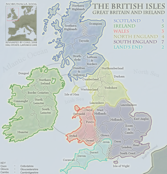
Ireland
As a matter of consistency, if you're going to call the Republic of Ireland Munster, you might want to call Northern Ireland Ulster, but my Irish geography is not brilliant and you may well have good reasons not to (given that the other areas you have named in Ireland may overlap with Ulster, Munster or both).
Typo
Dorest = Dorset.
Mountains
Your mountain ranges are a bit strange. There are no mountain ranges where you have put them, they exist elsewhere. Take a google at a physical map of Britain to see what I mean. Again you may be ahead of me on this and have departed from reality for a reason.
London looks pretty huge, but that that's probably intentional for the game.
I would call the light blue area 'Wessex' rather than 'Land's End'. (Land's End is the western most point of Cornwall). You might want to call South England 'Mercia' and North England 'Northumbria'. - Depends on the time period but from the names you have chosen they look like a reasonable fit.
Cheers
Ravs
ravells thanks for the comments!
This was actually a revamp of a current version of the british isles map currently on conquer club. For that reason my hands are tied on alot of issues. Some names you mentioned can (and will) be changed, others not so much. THe mountains are a little creative license for the sake of athsetics.
uslter was the name used on the original map. However with attempts to make the geography more acurate we went with northern ireland and spliting the republic into more regions.
London is also indeed bigger for the sake of fitting both the territory name and the arny numbers needed for the game!
Typo's will be fixed! You will com to learn I am not geatest speller
I think the heavy borders are trying to compensate for a the similarity between sea and land colour. I'd up the contrast with the water and see if you can then clean up the borders.
I don't find the mountains a problem but then I don't live in the UK to be overly concerned with accuracy.
Sigurd
THe contrasting borders are part of the images athetics! Remember this is also used for a board game so the highly visable boarders is a must o distiguish different regions!Originally Posted by Sigurd

Cheers for the comment thou1.
Artistic licence is great, but you really need to fix those mountains. There are no mountains on the south coast but there is a range of mountains on the English-Scottish border - the peak district to be precise. There are also a lot of mountains in the Highlands (of course).

The counties are all over the place. See: http://www.itraveluk.co.uk/maps/engl...county-map.gif
Another county map, including Scotland and Wales: http://badc.nerc.ac.uk/search/midas_...unties_map.gif
If you want to group counties ...
West Midlands is Shropshire, Staffordshire, Warwickshire, Herefordshire and Worcestershire
East Midlands is Derbyshire, Nottinghamshire, Leicestershire, Rutland and Northamptonshire
East Anglia is Norfolk, Suffolk and Cambridgeshire
The West Country is Cornwall, Devon, Dorset, Somerset and Wiltshire
Home Counties are Oxfordshire, Bedfordshire, Buckinghamshire, Berkshire and Hampshire(?) (also maybe Hertfordshire)
South East is Surrey, Kent, and Sussex
Last edited by Valarian; 08-18-2008 at 12:09 PM.
Google Groups for FGII Games:
European FG2 RPG - Fridays & Sundays (8pm UK time)
Using Ultimate FGII and can accept unlicensed player connections on some of the games
Hi
I like the colours you're using. Generally looking good. I think it's been mentioned already, but it's a good idea to keep consistency, particularly to cover the south of England than just put 'south coast'. Kent is named closer to London that London is. If you have space (like with Kent) if you put the tag in the center of the county it will look better and less confusing.
Also for Tayside, you've included Fife too. so either need to say 'Tayside & Fife' or put in the borders and make Fife separate. Here's more info...
http://www.hotels-scotland.co.uk/tayside.htm
The map link Valarian put up pretty much covers the detail you need for the counties
thanks for showing!
 Posting Permissions

 Reply With Quote


