Reply With Quote

Good map and nice colors! I like the way you used the icons for ports and airports and I would have used something closer for the cities.

Hello everyone, here is a map of the Solomon islands, done with QGIS, wilbur, photoshop and illustrator. The rivers were done with GIS data but the relief of islands was done with wilbur and photoshop, i wasn't able to find good elevation data for that part of the world

My Fantasy maps : http://www.cartographersguild.com/al...p?albumid=4205
Website: http://francoisgueydon.jimdo.com/fantasy/
Good map and nice colors! I like the way you used the icons for ports and airports and I would have used something closer for the cities.
Thanks Ilanthar, i guess you're right about villages (those islands aren't very populated so city is a bit too much for those) i was a bit lazy with symbols ^^
My Fantasy maps : http://www.cartographersguild.com/al...p?albumid=4205
Website: http://francoisgueydon.jimdo.com/fantasy/
There should be 90 meter SRTM data out there that you can use for terrain. In the next year or so (not helpful for this project), it's supposed to be available at 30 meter resolution worldwide.
If necessary, you can use the rivers to get moderately-plausible terrain by making the GIS rivers part of the sea selection and then doing the Wilbur fill Basins ( Fun WIth WIlbur, Vol 4 at http://www.cartographersguild.com/sh...ad.php?t=29412 shows the idea). Filling the raw coastline mask and then adding height based on the river-included coastline mask should give more plausible-looking terrain.
I really love this, especially the texture of the water (is there any chance you could post a link to the texture?). Definitely +1 reputation!
Last edited by SteffenBrand; 01-18-2015 at 04:00 PM.
Visit me on ArtStation.
the real height data is available in the DS 15 data set
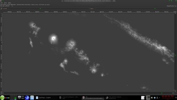
a screen shot from my copy of the ds15 data
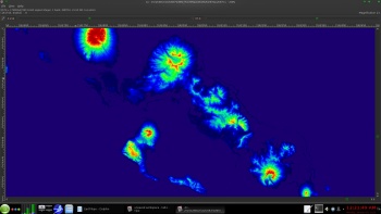
and a false color of the 7.5 arc second
ArcGIS formatted data that "GDAL_Translate" can easily handle
http://topotools.cr.usgs.gov/gmted_v...obal_grids.php
viewer
http://topotools.cr.usgs.gov/gmted_viewer/
PS
the DS15 is NOT the full planet
nor is the DS30
but between the two they DO make up the full planet ( minus some of the north artic)
for higher resolution use the 7.5 arc sec data ( 2.9 gig COMPRESSED "ds75_grd.zip" )
this data set has replaced the USA Space shuttle " SRTM" data
Last edited by johnvanvliet; 01-19-2015 at 12:27 AM.
--- 90 seconds to Midnight ---
--------
--- Penguin power!!! ---
Thanks guys for the comment and the rep! thx a lot waldronate for the wilbur tips and to johnvanvliet for those very usefull links about relief data, those aren't easy to find, great sharing
And about the water texture that will be a bit hard because i use 3 or 4 different textures combinated, i'll try to post the steps i followed for the water tonightOriginally Posted by SteffenBrand


Last edited by - Max -; 01-19-2015 at 04:45 AM. Reason: merging double posts
My Fantasy maps : http://www.cartographersguild.com/al...p?albumid=4205
Website: http://francoisgueydon.jimdo.com/fantasy/


Nice. It looks like some ancient satelite photos
 Posting Permissions