

 Reply With Quote


Looking good RevGunn. I also really like the Esrah version as well.
Cheers,
-Arsheesh


Well here is the updated version. Eriond tutorial.
Looking good RevGunn. I also really like the Esrah version as well.
Cheers,
-Arsheesh
If you are looking to create a map similar to those created by Fractal Terrains and Wilbur, I would spend the $40 on Fractal Terrains. I know not everyone has 40 bucks to spare (I have to stick to my monthly budget to the dollar), but now that I've learned a little bit about using the two together it is really easy to create some highly detailed land forms fairly quickly. I don't utilize all of the functionality of either of those programs, but they have made redrawing maps and parts of maps 1000 times easier than when I used to do EVERYTHING by hand.
I just started seriously doing digital maps about 3 years ago and I've tried many combinations of software, and if I had to pick a limited selection I would pick Photoshop, Fractal Terrains 3, and Wilbur. I haven't used GIMP in a long time, but I used to use it enough to know that it was pretty good for a free alternative to PS. I hated FT so much at first I returned it to Profantasy and got my money back. After I found the Israh tutorial I proceeded to try all kinds of various combinations of factors in FT and Wilbur and THEN I loved Fractal Terrains. It still frustrates me in some ways, but I stick by my suggestion to buy it.
I agree with your assessment that your map seems a little too mountainous, but then again, I feel that way about some of my maps too. If you are still shaping land and topographical features, I wouldn't worry TOO much about color right now. You can do whatever you want with the color and such in GIMP after doing the "shaping work" in your Terrain program of your choice.
Keep up the good work!
the PROBLEM withis it is Microsoft Windows ONLY software !"$40 on Fractal Terrains. "
if you use a Apple you are F***'ed
if you use one of the Linux OS's ( like the OP ) you are also S***'ed
most Linux users use Linux because they ROYALLY dislike Microsoft
and are sick and tired of Microsoft virus infections ( getting sick) and the corporate B***S**t
-- there is a very good reason that Microsoft has a "Star trek - BORG!!! " reputation
We are the Microsoft : Resistance is futile,your culture will adapt to service ours. Freedom is irrelevant. Self-determination is irrelevant. You must comply.
Wilbur at lease DOSE run well in the windows OS emulator "wine" ( Wine Is Not a Emulator ) -- recursive acronyms, gotta love them .
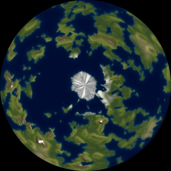
about the only real issue is the "rivers" in the ice at the poles - they do not map around a sphere ( yes i am a bit of a stickler on this point )
getting things TO MAP to a sphere is the hard part
normally this means adding erosion in remapped parts , then remapping those and rejoining the parts
-- a bit complicated and time consuming
in gimp have a look
use the distortion "polar coordinates"
the north pole
--- 90 seconds to Midnight ---
--------
--- Penguin power!!! ---
Thanks Arsheesh. That means a lot. You have taught me plenty.
I hadn't done the sphere projection on the last map. I think I could possibly just paint over the "rivers" in the polar regions. I really like the terrain generated with the clouds filters. The Israh style map was the greyscale output of the PlanetGen program. It works fine under WINE. I felt like it needed more land texture in general.
The Fractal Terrains Demo pretty much vomited when I tried to get it to work.
This second version was Arsheesh's Eriond procedure, except I used RobA's tutorial for the mountains so I could put them where I wanted them. I got them pretty close but in the steps I seem to have lost some of them. The only tweak I used was making the size on the Felimage noise smaller sized to fit in to the World Map scale better. This is the greyscale output of PlanetGen Wilburized and Israh colored.
There are parts of this I really really like. I thought it needed more texture. I don't think it will map to a globe either due in part to the edge I lost in the south pole area. The terrian was supposed to go all the way to the edge of the image.
This one was the first one, using a color height map out of PlanetGen. I greyscaled it in GIMP. I wound up with a bunch of valleys I didn't like. I love the deep river canyons at the edge of the plateaus. I really like a couple of the plateaus. Kind of have too many. There are some peices of terrain that positivley has to be really close to where it is on all these maps. The one big peak, a river off that bay south east of it. I also would like to figure out how to add some canyons south southwest of the big peak. I figure incise flow with Wilbur.
Each iteration gets closer to what I'm looking for.
I've been working steady on this for a few weeks. Lots of trial and error. I think I finally have the terrain the way I want it. Its possible to do it better maybe but I'm fairly pleased. I spent some time staring at a shaded relief map of the US, especially the mountain areas. Using Felimage and a variation of Rob's Regional style, I got something a bit more realistic. Well I think so anyway. Its painted with the Eriond colors, I have an idea for some different shading but I'll have to try that a bit later. Now, its time for labeling. I have to decide what all should be labeled at this scale, and hit the random generators for some place names.

Last edited by RevGunn; 03-29-2015 at 10:32 PM.
 Posting Permissions