Reply With Quote


The topography of the continental shelf would mostly depend on the dynamics of the tectonic plates.


Well .. I made this map yesterday (actually just a remake of an old map) and I was well satisfied until I looked at the ocean and realized, was crap.
I tried to remake the ocean in many ways, but nothing came close to being realistic.
Then simply I pulled out and come to you guys asking for help.
Someone knows how to make a realistic Continental shelf?
By the way, Many thanks to generous Arsheesh for sharing techniques and knowledge in the Tutorial "Eriond - A Tutorial for GIMP and Wilbur".
Sorry any grammatical error, I'm better with Portuguese than English.
The topography of the continental shelf would mostly depend on the dynamics of the tectonic plates.
One way to get a (very) rough approximation to a continental shelf is to blur your land layer and then trace around a roughly constant intensity in the blurred area. As Azelor points out, this won't be geologically accurate, but it will smooth over deeply-indented areas like your two gulfs while not extending too far out into the ocean areas.
http://lance-modis.eosdis.nasa.gov/i...roject=aeronet is a useful resource for looking at continental shelf areas. Two good examples are the west coast and east coast of North America (and South America to some extent). The west coast has little to no continental shelf area, while the east coast has a nice sloping coastal plain accompanied by relatively broad offshore areas.
Once you have the shelf area, use it to modify the lightness channel of the deep-sea color areas (increase lightness a bunch and possibly add a slight hue shift toward cyan from blue, especially for tropical areas). Then you can go back and put in some swirly bits of light green and muddy brown along coastal areas down-current from major river outlets.
One thing that I noted is that your coastline is almost uniformly fractal (it looks a lot like OldGuy's coast-wrinkling tutorial). Real coastlines are multifractal; that is, they are smoother in some places than others. The uniform coastline looks decidedly artificial.
you used wilbur
so running the erode cycles on 32 bit floating point height data ( *.bt format works best )
the underwater area will have been created ( the negative values in the data )
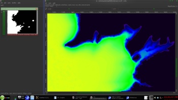
the Middle earth area here around Gondor ( bay of Belfalas)
-- the under water area only the land is black in this FALSE COLOR image
The depest area in the above image is -16510 -- that is in the yellow area
the green is -14000 to about -11000
the blue -11000 to 0
i use the negative values to gradient color the water mask
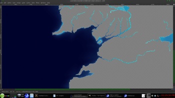
-- now this one is ONLY near the shore
this is one reason why i use 32 bit float image formats
Last edited by johnvanvliet; 09-17-2015 at 03:26 PM.
--- 90 seconds to Midnight ---
--------
--- Penguin power!!! ---
First, thanks for the help.
I realized the biggest problem of this map, I tried to make a realistic version of a map, it was too artificial, without considering real factors, which, as the own Waldronate said, is not geologically accurate.
So I decided to restart this map, this time the right way, so I'll create a new post, and would like to have the opinion of you in this new map.
New Thread Link.
Last edited by joaodafi; 09-17-2015 at 06:29 PM.
Sorry any grammatical error, I'm better with Portuguese than English.
Originally Posted by johnvanvliet

I have no idea what you're talking about, I am a beginner in WILBUR, but I will search and try to do something.
Sorry any grammatical error, I'm better with Portuguese than English.
this is what
i do not save the heightmap from wilbur as a 8 bit or 16 bit png
i use the 32 bit GIS format bt
that way a have positive and negative image data values
( negative values are BELOW sealevel )
then use the negative values to make a gradient mask that can be colored
like this
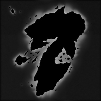
i used a "distance PDE transform " to make a pseudo height map and eroded it in wilbur ( 30 cycles)
saved it as a *.bt format image( 32 bit )
used GDAL to convert it to a tiff ( 32 bit )
then masked off the land with pixels of less value than the lowest negative value( -2900 the lowest was -2875.97 ) in the image and then normalized it from 0 to 255
that made the above preview
the up shot of using a 32 bit data format
is you not only have the land eroided
but you ALSO!!! have the ocean that is contoured to your land . no tectonic plates , just shallow water areas like in the Caribbean .
Last edited by johnvanvliet; 09-17-2015 at 06:11 PM.
--- 90 seconds to Midnight ---
--------
--- Penguin power!!! ---
Wow! Thank you very much for the detailed explanation, it was very much easier now.
Sorry any grammatical error, I'm better with Portuguese than English.