Results 1 to 7 of 7

Thread: Recommended alternative styles?

  1. #1

    Default Recommended alternative styles?

    This is a question that's vexed me to no end. I've made three video-gamy height maps, but they don't achieve the desired effect, and the light seems too harsh, the mountains and forests too ill-defined. I'm going for softer light, while still implying northerness, like northern France, Britain or Germany.

    (My tools: Photoshop [Middle East Version] and Paint)

    Generally, I draw a line map in Paint, and then port it over to photoshop. My most recent map involved cutting and pasting the real world's coastlines into new shapes, as a sort of inventiveness exercise, and making a map with the result.

    Usually in photoshop, I take that map, fill it and then make it a colored height map.

    Anyways, I'd like to figure out how to (easily if possible) do something a tad more like so
    https://scontent-cdg2-1.xx.fbcdn.net...93216566_o.jpg

    in regards to mountains and forests.

    Anyone got any ideas? I'd love to hear them.

  2. #2

    Default

    Perhaps you could show us what your current maps look like so we have a baseline?

    Torstan's shared some good techniques here over the years. I suggest a search in the tutorials section for his name. And he's also the one behind Fantastic Maps, where you can find additional tips.

    The bad news is that you're not going to get anywhere close to that "easily." Art is work, and it's going to take a lot of practice and dedication to get to that level of skill. As a point of encouragement, though, Torstan didn't start out at the level of mastery he currently exhibits. Here's the first map he posted here: http://www.cartographersguild.com/showthread.php?t=709
    Some nice hand-drawn lines there, but the map itself is nothing special. No matter where you're starting from, I believe you can certainly get there, but it will take some work.
    Bryan Ray, visual effects artist
    http://www.bryanray.name

  3. #3

    Default

    Quote Originally Posted by Midgardsormr View Post
    Perhaps you could show us what your current maps look like so we have a baseline?.


    Here's my 2 styles, more or less.

    1 is a pretty shoody version of a height map, not labeled with only token colors. I'm working on a filaized copy with better colors/labels as we speak
    Click image for larger version. 

Name:	VdXhfXW.jpg 
Views:	41 
Size:	909.0 KB 
ID:	77908
    The second is a 'parchment' style map
    http://www.cartographersguild.com/at...7&d=1390920630

  4. #4

    Default

    For your first style, it looks like you have a pretty uniform roughness across the entire image. There is no sense that any part of the island or continent is higher than any other. I am assuming that the lighter desaturated areas are meant to be higher? If so, what you'll want to do is to mix that information with the bump map, and then apply your Lighting Effects filter. If you'd like some help on a really nice-looking shaded relief style, I recommend these two tutorials by Pasis:
    http://www.cartographersguild.com/showthread.php?t=4405
    http://www.cartographersguild.com/sh...ad.php?t=16688
    A note on the terminology: Sometimes when Pasis says "bump map" what he is actually referring to is a "light map," where brighter pixels are where more light is hitting. A "real" bump map is just like a height map, where the value of a pixel indicates relative elevation. There is a distinction between bump maps, height maps, and displacement maps, but the differences are not important for our purposes here, so I'll leave it at that.

    Your second style looks like you're using a stamp-based approach, and I can see that you've encountered the same frustration as many people who try to use a stamping approach in Photoshop: Overlapping brushes don't look good. There is a solution for that! http://www.cartographersguild.com/showthread.php?t=7336

    I think I had more to say, but I've kind of lost track of my thoughts. Also, I'm at work, and I really shouldn't spend too much time here when I'm supposed to be doing something else!
    Bryan Ray, visual effects artist
    http://www.bryanray.name

  5. #5

    Default

    Extra question. Is there any way I could smooth out the 'landscape' of some of my bump maps? A lot of them have a lot of hills but very few plains.

    (Unfortunately I don't have the alpha maps or the black-white height maps for the map in question)

  6. #6
    Guild Expert johnvanvliet's Avatar
    Join Date
    Jul 2012
    Location
    N 42.39 W 83.44
    Posts
    1,091
    Blog Entries
    4

    Default

    terminology is really a big deal
    A "real" bump map is just like a height map, where the value of a pixel indicates relative elevation.
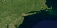
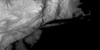
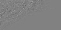
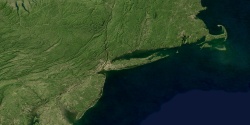
    An example: -- click on thumbnail for the 2000x1000 px image
    the texture


    a HeightMap ( 8 bit copy of the 32 bit float)


    and a shaded relief map
    -- a simple Emboss was used on the HEIGHT MAP


    and the texture shaded using the height map
    Last edited by johnvanvliet; 12-04-2015 at 02:28 PM.
    --- 90 seconds to Midnight ---
    --------

    --- Penguin power!!! ---


  7. #7

    Default

    Quote Originally Posted by Neptondoodle View Post
    Extra question. Is there any way I could smooth out the 'landscape' of some of my bump maps? A lot of them have a lot of hills but very few plains.

    (Unfortunately I don't have the alpha maps or the black-white height maps for the map in question)
    Without the height maps to work with, your best bet is going to be simply blurring the landscape where you want to smooth it. That will knock out the contrast on the ridges and make everything appear to be more level.
    Bryan Ray, visual effects artist
    http://www.bryanray.name

Tags for this Thread

Posting Permissions

  • You may not post new threads
  • You may not post replies
  • You may not post attachments
  • You may not edit your posts
  •