Page 1 of 2 12 LastLast
Results 1 to 10 of 11

Thread: Second real attempt at a world map

  1. #1

    Wip Second real attempt at a world map

    After some feedback on my first map, I decided to restart and went bigger as well. I'm aiming for a good size world to fit some of the story I have in mind.

    I still need to fix the water in the jagged land area towards the middle, not sure what went wrong with the layer there.

    Click image for larger version. 

Name:	Large World Finished 1920.png 
Views:	91 
Size:	3.79 MB 
ID:	83624

  2. #2

    Default

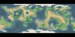
    It's a nice looking map. I like it.

    I don't know if you're looking for realism or not (some people aren't), but here are a few things to think about.

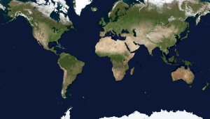
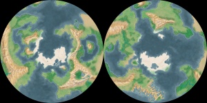
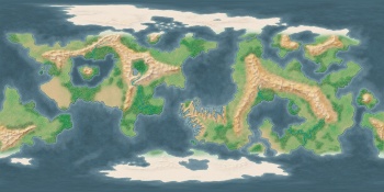
    Large enclosed seas like you show are rare on earth. I'm not sure what scale this map is, but even if it's a small area I would think that normal geologic forces would fill in those basins in a short time. Earth's biggest (the Black Sea or perhaps the Caspian) are relatively small compared to the size of the continents.
    In a similar note, the mountains, particularly in the continent on the left, have a lot of circular valleys with no obvious drainage. Erosion either fills in a basin or a river cuts an egress and you have a canyon of valley.

    Your coastlines all have about the same fractal dimension, which is a high-falutin' way of saying they all have the same degree of jaggedness (except for your saw-toothed peninsula, of course). Look at a map of Earth. Different coastlines are smoother or more jagged. Think about why that may be (currents, tectonics, etc.) and think about how those forces might play out in your world.

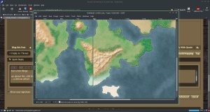
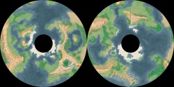
    If this is supposed to be a map of the whole world, or most of it, there are some other issues to think about. If it's a whole world, the land mass that extends across the eastern border and wraps around to the west does not line up. Are you including all the way to the poles? If so, are you using some fancy map projection? The poles are single points in real life. In rectangular projections that show the pole, that point is smeared out across the entire top of the map. You can't have ice cap and/or land as well as sea of varying depths at one point on the globe's surface.

    All that technical stuff aside, I still like this map. You have a nice color palette. The way you suggest different depths of the ocean and the continental shelves is very well done. For a second attempt, it is done very well indeed. I wish my second attempt - or my tenth - looked half as good.

  3. #3

    Default

    Thanks for the feedback. I'm not going for perfect realism. This map is for a homebrew fantasy world I'm working on. So somewhat realistic is nice, but I'm not aiming for perfect there. I might end up adding a floating island type area or some sort of deep chasm/crater.

    That said, I was intending that the top and bottom continents were polar regions, so I'll definitely need to extend those edge-to-edge. I might just removed that continent that goes off the left and right of the map to simplify things a bit.

    Back to Photoshop for round two on this thing.

  4. #4
    Guild Master Josiah VE's Avatar
    Join Date
    Feb 2016
    Location
    Winnipeg, Manitoba, Canada
    Posts
    2,098

    Default

    Well, in a fantasy world pretty crazy things can happen, so realism isn't mandatory.

    I like that shattered coast, looks pretty cool.

    I offer map commissions for RPG's, world-building, and books
    PORFOLIO | INSTAGRAM

  5. #5
    Guild Expert johnvanvliet's Avatar
    Join Date
    Jul 2012
    Location
    N 42.39 W 83.44
    Posts
    1,091
    Blog Entries
    4

    Default

    i am more a realist but...
    a fantasy world is well made by MAGIC

    but a few things

    as above the -180 long and +180 long sides are close but might need fixing if some 3d program is going to be used
    -- a 800 px offset


    i am also assuming this is in Mercator projection and approx. 70 north to 70 south

    for not showing the last 20 degrees of the polar area , it looks close to real

    this is the Earth 71 north to 71 south in Mercator projection


    only 13 pixels taller at 5.33333 pixel per degree
    --- 90 seconds to Midnight ---
    --------

    --- Penguin power!!! ---


  6. #6

    Default

    I started fixing the continent that isn't lined up, fixing the mountain range was easy enough, but I am not sure how to fix the "seam" that runs down the side when it it wrapped. My fault for running a continent from edge to edge like that.

    I'm going to work on the pole continents next, and try to get them to look a little better when it's wrapped on a globe.

    I also did some work around the mountains on the left continent, and the oversize "inner sea" on the right.

    Here is where I am at now.

    Click image for larger version. 

Name:	Large World v3 1920.png 
Views:	32 
Size:	3.80 MB 
ID:	83670

  7. #7
    Guild Expert johnvanvliet's Avatar
    Join Date
    Jul 2012
    Location
    N 42.39 W 83.44
    Posts
    1,091
    Blog Entries
    4

    Default

    the first thing i would do is remap to simple cylindrical 90 north to 90 south
    -- using isis3 to remap but qgis can easily do this - even on windows10


    then remap the north and south -- using gimp's built in polar tool

    ( just joined the two for posting here )

    then i would use the gimp plugin " resynthesizer " -- you have to build the source on windows using Mingw - but builds easily
    http://www.logarithmic.net/pfh/resynthesizer
    -- or just paint it

    then use the " Heal" tool to clean up the non matching edges
    ( used resynthesizer and the heal tool)


    then remap back using gimps built in tool


    and the fixed image

    but the poles are not correct yet
    -- this is better
    Last edited by johnvanvliet; 05-15-2016 at 08:36 PM.
    --- 90 seconds to Midnight ---
    --------

    --- Penguin power!!! ---


  8. #8

    Default

    Awesome, thanks for the help. Going to work on this now.

  9. #9
    Guild Master Josiah VE's Avatar
    Join Date
    Feb 2016
    Location
    Winnipeg, Manitoba, Canada
    Posts
    2,098

    Default

    I honestly have no idea what you're talking about with the lined up continent, but looking pretty nice so far!

    I offer map commissions for RPG's, world-building, and books
    PORFOLIO | INSTAGRAM

  10. #10
    Guild Expert johnvanvliet's Avatar
    Join Date
    Jul 2012
    Location
    N 42.39 W 83.44
    Posts
    1,091
    Blog Entries
    4

    Default

    I honestly have no idea what you're talking about with the lined up continent, but looking pretty nice so far!
    see the first image in post #5
    a 800 px offset
    --- 90 seconds to Midnight ---
    --------

    --- Penguin power!!! ---


Page 1 of 2 12 LastLast

Posting Permissions

  • You may not post new threads
  • You may not post replies
  • You may not post attachments
  • You may not edit your posts
  •