Reply With Quote
without knowing how you want to go about that .....
how are you at drawing ? pen and paper ?
me i would take a software approach and synthesize the data
but i do not touch Microsoft


I'm sure this is answered somewhere by someone already but my searches so far have been futile. I have CC3+ etc. as well as photoshop.
What I'm wanting to do is take either a large continental map and zero in to make a more detailed area map or take an area map and expand outward to make a larger view of the same landmass.
Is there a way to keep/copy coastlines (etc) but change the scale to make a map that shows more or less of the area?
I'm a long time photoshop/photography guy so I'm not a noob at this but I'm not sure what technique would work in CC3+.
without knowing how you want to go about that .....
how are you at drawing ? pen and paper ?
me i would take a software approach and synthesize the data
but i do not touch Microsoft
--- 90 seconds to Midnight ---
--------
--- Penguin power!!! ---
I'm not talking about the drawing aspect per se. And I never mentioned microsoft so not sure why you did.
I'm using CC3+ and/or photoshop. CC3+ is shorthand for Campaign Cartographer 3 Plus from Pro Fantasy a long standing mapping software company for gaming.
I'm talking about if I've made a map of a village near a river and want to expand outwards and map the area around that village or I've drawn a continent and want to zoom in and create maps of a city on the exact same coast line.
There are discussions of this very topic at the ProFantasy forums. It's a very popular topic, unfortunately.
So one thing I found out is that if you make a city in City Designer or a dungeon in Dungeon Designer you can link them to your larger continental map in CC3+. This isn't what I was looking for but it is a start
for adding details
How you go about it dose depend on the map in question
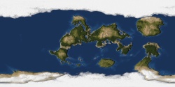
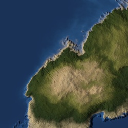
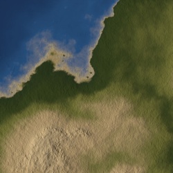
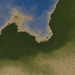
i tend to make full planet maps
a crop ( and shaded)
zoom in and added detail ( and shaded)
zoom in and added detail ( and shaded)
i could add LOD and zoom into an island in the bay
--- 90 seconds to Midnight ---
--------
--- Penguin power!!! ---


Is this on a spherical planet? If so, this gets complicated. Projection from a sphere to a flat map causes distortion. You can change the kind of distortion and where it it, but you can't eliminate it. If you don't want distortion, you need a real 3D globe.
So for any particular extent (area covered by a map) you should pick a projection that minimizes distortion within that extent at the expense of areas outside it. Unless everything you are doing is at a fairly large scale (Neighbourhood to whole city isn't a problem for instance) significant changes of extent require changes of projection in order to keep distortion minimal for that map.
There is a trick that sort of lets you cheat this, and is how zoomable web maps like Google Maps and Open Street Map work. If you use the Normal Mercator projection, then when you zoom in to large scale, you get something that works reasonably well (you just need to adjust linear scale based on latitude). This cheating breaks down in between at medium scales though, particularly for big shapes at high latitudes. Canada for instance looks very wrong. Bear in mind that Normal Mercator has weaknesses as a reference map, in particular it can never show the whole planet as the poles end up infinitely far away and have to be chopped off. A square Mercator map centred on the equator chops off the poles a bit past 80 degrees.
If your world is flat, then you can zoom and crop without worrying about projections. You do have to worry about other things like avoiding all the concepts that we take for granted from living on a sphere (Latitude and longitude, celestial navigiation (Using the stars to figure out your location), seasons, climate varying with latitude (As there is no latitude), the horizon, being able to see further by getting higher, compasses) Some of those can be fixed by applying appropriate magic (Done right this could aid in making the world seem fantastic and magical) but it's something you need to work out.
A "large continent" is probably the most inconvenient thing to work with in terms of projections. It's big enough to make sure you have significant distortion problems, but it's not a full planet so you can't just use an existing world optimized projection.
that was really great info and kind of what I was leaning toward.
Originally Posted by johnvanvliet

All good points. Food for thought
for the zooming in i used the gimp resynthesizer plugin
http://www.logarithmic.net/pfh/resynthesizer
and the enlarge and sharpen script
normally i would also use the gmic upscale inpaint code and then blend the two images ( better results )
but there is a limit on just how much time and how big
this tiny 512x512 px example took a few min. for each iteration
and it dose NOT scale well
as you increase the size you exponentially increase the time
--- 90 seconds to Midnight ---
--------
--- Penguin power!!! ---