Reply With Quote
Check out Pixie's tutorial DEM's to a Contour-Map. Pixie used real-world Digital Elevation Model data, but you could use cloud-generated terrain just as easily. And it winds up with a contour map of the sort you're looking for.


Hi everyone,
Sorry for my english but i will try to explain my problem.
I made a scale map (1:25000) with real measurement, and i want to do the topography (and next the hydrology). I have seen tutorials here that used cloud and different cloud technique but i want to make mountains where i want, not with a "random" filter. Why? because i need to have levels of geology mountains like this: http://www.studiomaven.org/images/8/...Topography.jpg
The question is: How i can do that? in photoshop for example.
See you later and thanks.

Check out Pixie's tutorial DEM's to a Contour-Map. Pixie used real-world Digital Elevation Model data, but you could use cloud-generated terrain just as easily. And it winds up with a contour map of the sort you're looking for.
if you already have contour lines on a map there are a few ways of converting that to a 16 bit ( or 32 bit) black and white height map
using qgis and inkscape for a vector line contours
this can also be done in Blender
or a close approximation can be done in Gimp and using the "Morphological filter" run erosion and dilation passes on
-- works fairly well but not vert accurate , just close
and if this is a real world location
the real height data is available
this can be processed in Qgis to output just counter lines
or even in gimp or photoshop
Last edited by johnvanvliet; 07-08-2016 at 05:17 PM.
--- 90 seconds to Midnight ---
--------
--- Penguin power!!! ---
If you have the DEM and want contours then use QGIS. If you can draw the contours and want the DEM then this is how I do it.
https://www.cartographersguild.com/s...l=1#post296662
part of this thread:
https://www.cartographersguild.com/s...ad.php?t=33666
I have seen the tutorial, he explain in the last step something interesting about the contour-map, but there is another way to do the mountains like cloud-generated? (without using the filter cloud).Originally Posted by wdmartin

I no have a DEM yet. I need first make mountains where i want, the technique of cloud and difference cloud dont help me, because its generated a random "mountains".
Thanks.
PD: my terrain is a ficticial map with real measurement, and i want to use only photoshop.
Last edited by Yasser Pulido; 07-08-2016 at 10:10 PM.
like say the city of Rio (The Olympics ) but with different names ?my terrain is a ficticial map with real measurement.
if you can post a image then we can see it, and guide you in the direction you need .
i am only guessing but something like i did in this post
https://www.cartographersguild.com/s...ad.php?t=34480
turn a image into a heightmap
--- 90 seconds to Midnight ---
--------
--- Penguin power!!! ---
Hi John,
I really liked your work in that post. I need to know how to make the field in my terrain and get the countour of the relief or line elevation.
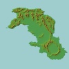
This terrain has about 500.000 km2. The color green means which should be the hightest elevation at 1000 m.
What is the best way to do it?
have a look through this tutorial section
https://www.cartographersguild.com/s...ad.php?t=29412
then you can decide on shading or on making contour lines from that
in the link i posted all i did was use a paint brush to paint the basic heights
then eroded it in wilbur
then used a inpainting tool to resynthesize the sections of the color to remove the mapping elements ) buildings and roads and such)
--- 90 seconds to Midnight ---
--------
--- Penguin power!!! ---
i have seen the tutoriales, and i tried to follow one of them. the result of the test is this:
why does this happen? the river is very straigth...
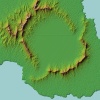
Now, how to get outline of this relief?
And, you use something special to get this result in photoshop?
Thanks!
let me play around with your green and white image
then i can post a few intermediate images
the real strait rivers are from the land being too flat and not noisy enough
also i tend to EXAGGERATE the height
the image of mine you posted has the height a bit too tall
--- 90 seconds to Midnight ---
--------
--- Penguin power!!! ---