Reply With Quote


Hi there perfectdisaster. Well a reference map need not be pretty, or complete. It's merely an aid in map creation. And this looks to be a very serviceable reference map. I look forward to seeing the next stage of this project.
Cheers,
-Arsheesh


I'm pretty new to map making. I tried making a map for a fantasy novel idea I had in my head about a year ago and eventually gave up on both (the novel and map). Recently I picked both of them back up, changed basically everything but kept some elements are still the same. I tried mapping it all in GIMP (I read at least a dozen tuts on map-making in GIMP or Photoshop) and wasn't liking what I had (for a lot of reasons), and found myself back at square one. This time I decided to sketch it first before doing anything in GIMP (besides picking my color palette).
In it's current state, it's not very pretty. The mountains are brown, the hills are pink, all of the waves are the same opacity, the font is hard to read because it's purple, etc. There are a lot of mistakes, and a lot of things to add. I really wanted to see the process unfold, and this seemed like a good way to do it. That and I hope it'll hold me accountable. Hopefully.
Anyway, all of the cities (or some of them) are initialed for my benefit. I know no one knows what any of those mean, but eventually there will be some sort of bullet and the city name. Marseedin (Mars-eed-en), marked MEN, is the capital of Astrea (As-tree-a) and Glimmermoor, marked GM, is the capital of Ozpya (Oz-pe-a). I'm also working on building the religions of these two countries, which will play into the names of the cities, forests, rivers, mountains, etc., and the houses while I'm working on this, so I'll try to include some sort of history while I go. Like the citizens that live in the desert-portion of Ozpya (the north-eastern corner of the continent) will be sun-worshipers, and Apdar's Wall and Apdar's Fort, marked AF, are named after the God of Building Things (or something more eloquent than that, I don't have all the details sorted yet). Apdar's Wall is built on the Astrea side of the border, and the rest of the border is split down the Bleak Peaks.
That's all I got for now. I'll take a food break, and then I'll get to the next phase of the map-making process: putting it in GIMP and sketching over the coastlines.
Hi there perfectdisaster. Well a reference map need not be pretty, or complete. It's merely an aid in map creation. And this looks to be a very serviceable reference map. I look forward to seeing the next stage of this project.
Cheers,
-Arsheesh
I'd say, promising start and I'm eager to see more !
Arsheesh and thomrey, thanks! I appreciate the words of encouragement, especially being so new to map making. And I'm bit of a perfectionist, usually my rough sketches are color coordinated and much easier to read.
I'll be also using a Bamboo tablet, which definitely helps on all of the drawing.
Two tries later, (GIMP froze and I hadn't saved, whoops, and I got the sea coloring mixed up) this is what I ended with.
My canvas size is 3500x2000, and I resized my sketch to 3000x2000 so that there's some more open space on the sides (something I always forget when I'm sketching). I ended up getting rid of some islands, adding new ones, adding a new lake, and then resizing all of the other lakes.
I didn't want the lakes to be too similar to the ocean in color, so I went and colored them the color that my rivers are probably going to be. I'll probably end up changing the coloring later on, but for now it'll do.
Also, I'm the type of person that measures how long it takes me to do project by what the movies/TV shows I watch while working. It's an easier way for me to measure how long it takes me to complete a project, especially after a couple weeks have passed. So this part was made while watching Muppet Treasure island, because Tim Curry.
Tomorrow, or later today, will be my favorite part: mountains. (Hint sarcasm.)
Last edited by perfectdisaster; 08-25-2016 at 04:10 AM.
everyone is using pc to create mapsbut still good job and can someone tell me how to upload my drawings im new to this
To the uploading, after you save your map as a JPEG or PNG, you can upload it in one of the forums. When you create a new thread click on the "Insert Image" button and just upload the image from your drive or internet. In case you need visual aid, here's a screenshot:Originally Posted by blue adventurer

It takes a few seconds for it to load after you've pressed upload, but it'll upload. Hope this helps!
Today was a busy day. I went ahead and changed my color palette, so that meant I had to recolor my sea and land. Then came the mountains (and volcano), and then I went ahead and added my border, because I'm scatterbrained sometimes. The key will go on the parchment on the left, and the compass will go... somewhere. That part I haven't decided yet.
But this is what I got done today:
I used the Fuzzy Brush #19 to color the mountains and volcano. The colors from the volcano aren't in the palette, but it's probably my favorite part of the map so far. The parchment background is from Jonathan Roberts (off-site), and you can check out his map-making site here.
I'm not in love with my mountains, but thus far they're my best attempt.
Today I worked while watching another project from The Jim Henson Company, the TV show Dinosaurs, seasons one and two.
That'll probably be all for today. I need to have some sort of meal and take a break. Tomorrow I'll get to the forests and rivers, maybe some of the hills depending on time.
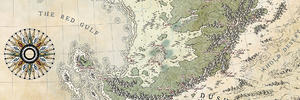
So it's been a couple days, but I've changed the map... again. The coastlines on the previous drafts was a little... weird, so I figured the best solution was to just resketch my coast. (It was the solution.) So, while I was re-sketching, I added (and took away) some islands. Though I liked that there was a open part of the sea on the left side, so I'll probably end up redoing the sea. Again.
But here's my map in it's current state:
Once I started on my forests I rediscovered the smudge tool, and then decided that'd be a good tool for my mountains so I went back and redid all of them - which look much better now. I'll probably only label five or six of them, depending on the font. I've got a couple serif fonts in mind, and then there's always Futura.
I decided to put some forests on the islands because they needed something. It took awhile, and later I might go back and add a forest on the blank islands. Or if I'm feeling particular brave, a mountain on the island in the upper left hand corner.
Next came rivers. It took me a couple tries to get the shading and thickness I wanted, but I'm happy with how they look for now. I also added more rivers because it felt like there wasn't enough of them.
The only thing I hate more than making mountains is hills. They're like mini mountains. (They're not, but they are.) This is attempt number one. Eventually, I'll go back and redo them (probably two or three times). Odds are, these won't be the hills in my final draft.
I started on Apdar's Wall after I saved the last PNG, and I'm still unsure with how I want to tackle it. I don't want it be just a line because it'll look boring, and I want something a little more detailed. So I'll be experimenting in Inkscape for the next few days until I get it figured out. Whenever I get frustrated with that, I'll probably actually start coloring in the desert. Or adding more forests. Or literally anything else.
All of the changes were just done listening to music, mostly because it was more tedious and I didn't want to get distracted by a movie or TV show... and I couldn't decide on anything.
That's probably all until I get the wall finished. Or whatever else I do stalling making the wall. Either way, it probably won't be for a couple days.