Was it maybe my Japan Map ? https://www.deviantart.com/schwarzkr...-WIP-417716966
Also, I am not sure blocky and unrealistic is a praise


Was it maybe my Japan Map ? https://www.deviantart.com/schwarzkr...-WIP-417716966
Also, I am not sure blocky and unrealistic is a praise
I think doing such a sheet for other map elements would be very cool. Forests, Roads, Coastlines, Frames
I miss being able to "like" posts here.Originally Posted by Schwarzkreuz

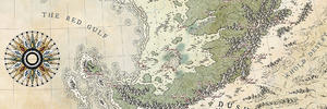
Great compilation. Here are my style if anyone would like to be inspired by it.
Attachment 136816
Last edited by Carnifex; 12-29-2023 at 11:43 AM.
My sites: http://www.facebook.com --- http://www.stormring.com --- http://www.fantasymaps.net --- http://www.megatongames.com --- http://www.darktowershop.com
My finished maps: here
Did anyone ever put together these? If not, maybe I will get around to it one of these days...
DeviantArt: https://www.deviantart.com/turambar91
Maybe it's one of Gamerprinter's such as in this thread: https://www.cartographersguild.com/s...ll=1#post43889
When its over and you look in the mirror, did you do the best that you were capable of? If so, the score does not matter. But if you find that you did your best you were capable of, you will find it to your liking. -John Wooden
* Rivengard * My Finished Maps * My Challenge Maps * My deviantArt
Hmm, no, it's none of them. I might give up the search now. Those last few suggestions look so good that they are worthy of inclusion in the chart regardless, when I do the next update...
Thanks for the suggestions, guys.
THW
Formerly TheHoarseWhisperer
https://www.cartographersguild.com/a...chmentid=83031 J Edwards Co-op country map. Not the Japanese one you were looking for but...
Last edited by Falconius; 11-01-2016 at 02:53 PM.

Well done there
 Posting Permissions


 Reply With Quote