Reply With Quote


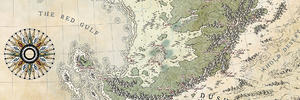
That's a spectacular first regional map. I love the cheeky pink twist on the traditional altitude shading colours - a pleasant change from orange and brown


this is one of the first regional map that I make in such detail.
I accept advices of any sort
Last edited by Impesio; 04-18-2017 at 05:07 PM.
That's a spectacular first regional map. I love the cheeky pink twist on the traditional altitude shading colours - a pleasant change from orange and brown
Very impressive, nice job on this, I'll be keeping my eyes peeled, and look forward to seeing more of you're work.
Nice looking topography map. Atlas style. It is already very good, i have never done this kind of map yet, so no advices from me, but you may look at vorropohaiah maps. He is doing his fantasy world in atlas style which is marvelous. You may get new ideas by studying his maps.
Great looking atlas map. I'd add a border but it's already wonderful !
Plus :
Originally Posted by Voolf

Very nice work!
"We are the music makers, and we are the dreamers of dreams"
Great map! Apart from optional elements to add (frame, key, scale), I've nothing more to say.
Thank you all for the support. If you want to see my other maps and my WIPS You can check out my deviantart (Impesio Deviantart on google).
I didn't inster the optional elements because it's a very large map and Pebahan is only 1 region
He's like my father in cartography ahaha
My advice is to keep posting theseThis is absolutely stunning!
EDIT: I just noticed that the River Police may pay you a visit as the lake labelled Gashpebh has two rivers flowing from it. This doesn't tend to happen unless it's seasonal and/or the area through which the rivers flow is generally a wetland. Also the Mur river seems to diverge into Mur and Haar and they drain into the sea at some considerable distance. Rivers would never do this. They've signed an agreement and a charter and that.
Last edited by Straf; 04-21-2017 at 11:37 PM.
I don't know If I am breaking some sort of rule doing this... but I'll do.
I am correcting what Riverl Police said to me (I still have to finish the corrections), but I'm working on the biomization of the territoy. I'd like to know your opinion about it and if for you this fit /doesn't fit in the map style.
 Posting Permissions