Reply With Quote
Hey Snodsy
Its a delight to see you doing another map.
This looks seriously interesting, and I'm definitely going to be watching


Following up on the last Tutorial I just finished I thought I'd use that style and play it out on an existing topo map.
The USGS website has topo maps of the entire United States for free use.
https://viewer.nationalmap.gov/basic...opo%20Download
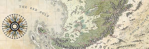
So I downloaded a PDF topo map of Big Bend Utah, close to MOAB (Arches National Monument) - The PDF comes in layers - main topo, secondary topo, rivers, water sheds, forested areas, trails and roads. Also an image file.
I am able to take this PDF into Adobe Illustrator - it comes in as one layer - but in Illustrator you can grab similar color/stroke elements at once and then move each to it's own layer - so I can grab a blue water line and SELECT SAME COLOR STROKE and it selects all blue lines.
Then in Illustrator, on each layer I color the elements BLACK and select each layer individually and cut and paste into Photoshop. I can then color each layer in Photoshop as a COLOR LAYER STYLE.
HINT: Size the Illustrator file same size as what you want the photoshop image to be - then cut the Illustrator Art and then OPEN NEW PHOTOSHOP File - It knows that artwork is cut and waiting to be pasted, so it makes the art board the same size as the file you are ready to paste.
I will use the secondary topo lines, as well as the watershed, as just reference, but keep the main topo lines to build my cliff sides. I also BLUR the Illustrator import topo lines since they comes it a little harder edge than my BRUSH in photoshop.
So here is an area that I started adding my style of topo lines to the Main Topo lines from the USGS.
Here is USGS map brought into Illustrator to start. I'll continue to add this style over the entire map.

Hey Snodsy
Its a delight to see you doing another map.
This looks seriously interesting, and I'm definitely going to be watching
Free parchments | Free seamless textures | Battle tiles / floor patterns | Room 1024 - textures for CC3 | GUILD CITY INDEX
No one is ever a failure until they give up trying
Update from weekend line work. Defined flood plain and ground levels. Will add human activity and some geological features - arches and such as well as vegetation. The Main contours lines throughout the drawing are USGS contour lines brought into photoshop.
Comments welcome.

It's looking awesome, Snodsy! The shading is excellent, as well as the contour lines. I suppose you'll add some shading to the rivers? They look a bit flat right now.

Very cool...
My Finished Maps | My Challenge Maps | Still poking around occasionally...
Unless otherwise stated by me in the post, all work is licensed under a Creative Commons Attribution-Noncommercial 3.0 United States License.
I agree with the Steel General.
I see Ilanthar is almost impatient for you to finish everything already! LOL!
(umm.... so am I)
Free parchments | Free seamless textures | Battle tiles / floor patterns | Room 1024 - textures for CC3 | GUILD CITY INDEX
No one is ever a failure until they give up trying
This looks amazing! I love those deep shadows.
"We are the music makers, and we are the dreamers of dreams"
Very nice linework. One thing to watch out for is that watercourses always cross contours at right angles (follow the path of steepest descent).
Very nice start snodsy! It's great to see you do another map again. Will keep an eye on this one!
That's gonna be awesome !