Page 1 of 2 12 LastLast
Results 1 to 10 of 11

Thread: Looking for software recommendations

  1. #1
    Guild Novice silk186's Avatar
    Join Date
    May 2017
    Location
    London
    Posts
    20

    Question Looking for software recommendations

    Hello everyone, I've come here after having no luck asking on other sites.

    I'm a PhD student in the UK, working on Chinese geopolitics.

    I'm looking for mapping software that will allow me to produce a few maps of China and the South China Sea. Some maps will have provinces shaded in different colors. Others will have locations or resources, pipelines and rail-lines. Of course, software that included this data would be even better. I will also be showing the rail-lines and pipelines extending across Europe and Shipping lanes to Africa.

    I don't need an overly complex work suit. I want to produce something like what i see on the BBC website an other new sites.
    I've seen a few that are good for North American and Europe but not for all countries.

    I've tried SmartDraw 2013 but it only has country maps of China and doesn't included provinces.

    Interactive map: iMapBuilder appeared to be better at first, at least it has provinces in the map of China. It is based off of Gmaps v2 uses google maps. The zoom is an issue though as I have to choose between losing all detail or only showing one part of the map of China. It appears to be designed for websites.

  2. #2

    Default

    Hi Silk

    Other than buying or renting some kind of GIS software, and seeing that you are a student with possibly limited funding, you could try GIMP, or Krita. I think the type of map you are describing could be better done in a piece of vector software, though. I use CC3, and in many ways it would be ideal if you can't afford the vector version of PS, as its a one time purchase for life, but if you have no money at all to spend on anything you could try something like Inkscape?

    I'm not an expert on that software at all, but if you're lucky ChickPea might say a couple of things about it for you. It's her favourite software

  3. #3
    Guild Novice silk186's Avatar
    Join Date
    May 2017
    Location
    London
    Posts
    20

    Default

    Hi mouse, thanks for the recommendations. i find it surprising the photo editing software is recommended for this type of mapping.
    I want to produce maps like these. Does anyone know what software is popular with media sites like the BBC?
    i watched some videos on map making with GIMP and they were all from hand drawn fantasy maps.
    Click image for larger version. 

Name:	map-china-third-front-1.jpg 
Views:	37 
Size:	157.0 KB 
ID:	96169
    Last edited by silk186; 05-30-2017 at 05:10 PM.

  4. #4

    Default

    I have no idea what the BBC use, but you would certainly be better off with a vector app.

  5. #5
    Administrator ChickPea's Avatar
    Join Date
    Jan 2015
    Location
    Sunny Scotland
    Posts
    6,884

    Default

    Silk, I'm not sure what the Beeb use either, but certainly looks like vector.

    If you've money to spend, take a look at Adobe Illustrator. If not, download Inkscape for free at inkscape.org. Also, have you had a look at Open Street Map (www.openstreetmap.org)? You can export data from there in SVG, which is Inkscape's native format. This allows you to import Open Street Map's data directly into Inkscape to manipulate as you please. I haven't a whole lot of experience with this, as I'm more into fantasy mapping, rather than real world, but I'm sure there are lots of tutorials on the web. Of course, other guild members might have more useful suggestions for you, but hopefully this can be a starting point.
    "We are the music makers, and we are the dreamers of dreams"

  6. #6
    Guild Novice silk186's Avatar
    Join Date
    May 2017
    Location
    London
    Posts
    20

    Default

    Quote Originally Posted by ChickPea View Post
    Silk, I'm not sure what the Beeb use either, but certainly looks like vector.

    If you've money to spend, take a look at Adobe Illustrator. If not, download Inkscape for free at inkscape.org. Also, have you had a look at Open Street Map (www.openstreetmap.org)? You can export data from there in SVG, which is Inkscape's native format. This allows you to import Open Street Map's data directly into Inkscape to manipulate as you please. I haven't a whole lot of experience with this, as I'm more into fantasy mapping, rather than real world, but I'm sure there are lots of tutorials on the web. Of course, other guild members might have more useful suggestions for you, but hopefully this can be a starting point.
    Thanks ChickPea, I've noticed the emphasis on fantasy sites here. I don't mind paying for something and or seeing if I can get a free or cheap educational copy.
    Adobe Illustrator looks very powerful and a lot of work to learn and use.
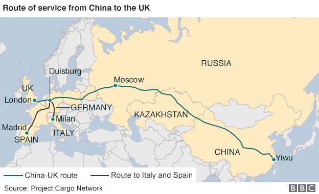
    Inkscape sounds interesting due to support for the openstreetmap standard. It would be a lot of work to hand draw a the rail line from Beijing to London.

    I find this guide on BBC mapping.
    You MUST use Bing® Maps (Microsoft Virtual Earth) as your interactive mapping provider.
    At present, you MUST NOT use Google Maps on bbc.co.uk.
    This answer is very detailed.
    I wish i could find a quote or spoiler option.

    Adobe Illustrator video for anyone else interested

  7. #7
    Guild Expert johnvanvliet's Avatar
    Join Date
    Jul 2012
    Location
    N 42.39 W 83.44
    Posts
    1,091
    Blog Entries
    4

    Default

    there is a bit of a steep learning curve but Qgis is under the GPL license and free
    http://www.qgis.org/en/site/

    however Arcgis is the industry standard but at a monopoly price of $1500+


    as for shading inkscape and gimp are great tools
    --- 90 seconds to Midnight ---
    --------

    --- Penguin power!!! ---


  8. #8
    Guild Novice silk186's Avatar
    Join Date
    May 2017
    Location
    London
    Posts
    20

    Default

    Thanks johnvanvliet, I've installed Qgis and it does indeed seem to be on the difficult side to get started with.
    I've checked and I can get ArcGIS from UCL so that is also an option if it is more suitable and easier to use than Qgis.

    Viz World and Viz Curious Maps seem to be the standard in broadcasting but doesn't even seem to have a trial version.

  9. #9
    Guild Novice silk186's Avatar
    Join Date
    May 2017
    Location
    London
    Posts
    20

    Default

    Now that is seems I would be best served with Qgis (alternative is Arcgis) + illustrator (alternative is Gimp) i'm looking for tutorials.
    I've looked in the tutorial section and did see anything for non-fantasy mapping with Qgis.
    Can anyone point me in the right direction?


    ***I've done some reading between Arcgis and Qgis, seems that Arcgis can be better is some very complicated cases but Qgis has not liscencing restrictions and is much more responsive in comparison to complaints of long loading times and crashes with Arcgis. Either will work for most users, I already have Qgis installed.

  10. #10

    Default

    Hi silk186,
    Have you tried any Udemy course? Here's the one I'm planning to choose: Core Spatial Data Analysis: Introductory
    essays about using GIS with R and QGIS. What illustrator are you using?
    Also: What are the steps to export correctly from QGIS to Adobe Illustrator? Thanks.
    Last edited by arthurnottheking; 01-22-2020 at 01:31 AM. Reason: one more question

Page 1 of 2 12 LastLast

Tags for this Thread

Posting Permissions

  • You may not post new threads
  • You may not post replies
  • You may not post attachments
  • You may not edit your posts
  •