Page 3 of 15 FirstFirst 123456713 ... LastLast
Results 21 to 30 of 151

Thread: How to get your rivers in the right place

Hybrid View

Previous Post Previous Post   Next Post Next Post
  1. #1
    Professional Artist Nomadic's Avatar
    Join Date
    Aug 2008
    Location
    The great northwest
    Posts
    355

    Default

    I wonder if you got the idea for lake amounts by looking at state/country lake maps. For example, a lake map of oregon will show many rivers and only a few lakes. The issue with that is that there are many more lakes then there appear to be (they are all just so small that they don't show up on a state map).

  2. #2
    Community Leader NeonKnight's Avatar
    Join Date
    Aug 2007
    Location
    Surrey, Canada, EH!
    Posts
    5,051

    Post

    Some good Info there Red Robes, but just thought I would point out a few 'exceptions' because as we know, ALL rules are all about exceptions

    Endorheic lakes are lakes that do not drain away to the sea, and as a result any and all rivers/streams etc that empty into one of these lakes never go to sea. The water in these basins leave only by evaporation or seepage into the underlying bed of the basin. Often these lakes are seen on the interior of old Volcano collapsed domes and such, but the DEAD SEA in Israel is perhaps the most famous of these types of lakes, with the Caspian Sea being another famous one.
    Daniel the Neon Knight: Campaign Cartographer User

    Never use a big word when a diminutive one will suffice!

    Any questions on CC3? Post them with CC3 in the Subject Line!
    MY 'FAMOUS' CC3 MAPS: Thunderspire; Pyramid of Shadows; King of the Trollhaunt Warrens; Demon Queen's Enclave

  3. #3

    Default

    First of all, thanks Redrobes for a great tutorial. I found it very informative.

    As far as frequency of lakes go, I live in Windermere ("among the lakes") Florida - can't go 1 mile without running into a large body of water (which, btw, is inevitably infested with alligators). Limestone makes for a very permeable foundation with lots of underground waterways and springs bubbling up everywhere. No mountainous glacial melt for us though.
    FantasyMapMaker.com - free fantasy maps for commercial or personal use ~ Campaign Cartographer 3 Review

  4. #4
    Community Leader Gandwarf's Avatar
    Join Date
    Jun 2008
    Location
    Netherlands
    Posts
    3,012

    Default

    The Netherlands has lots of lakes as well, especially in the north. We do not have as many lakes as the Swedes however
    Check out my City Designer 3 tutorials. See my fantasy (city) maps in this thread.

    Gandwarf has fallen into shadow...

  5. #5
    Administrator Redrobes's Avatar
    Join Date
    Dec 2007
    Location
    England
    Posts
    7,201
    Blog Entries
    8

    Post

    Thanks Neon, I didn't know the word for that. I think Waldronate mentioned it a long time ago too. I did say that there was three things that can occur for a lake and that was number 3. You can get it with a river too just running into nothing across savannas when the rainy season comes and goes. In either case these are rare tho.

    When lakes evaporate only then all the impurities in the water concentrate so the dead sea is salty. That's also occurring in many places in the world where they irrigate crops since all the water is taken up by plants and evaporated leaving progressively salty and infertile soil. Theres some beatiful round shapes in the desert like this which is circular irrigation zones.

    http://maps.google.co.uk/maps?hl=en&...37708&t=h&z=11

    Oh and I think I had just better say that lakes are in fact extremely numerous and all over the place contrary to what I said before. Perhaps I just live in a land that does not have all that many...

  6. #6
    Community Leader Facebook Connected Ascension's Avatar
    Join Date
    Jun 2008
    Location
    St. Charles, Missouri, United States
    Posts
    8,392

    Post

    I think the problems with lakes is that people sometimes think of ponds as lakes and then what is the scale of the map. On continental style maps, most lakes would not be seen at that scale. On a regional scale, then, lots of lakes would be seen. On a city scale you could put in as many ponds as you like. Now this is all for a certain amount of realism. If some lake or pond happens to be quite important and you want to put it in, then you're getting into the representational realm and away from the realism. It's the balance that's hard and sometimes we have to compromise one way or the other for the sake of the story.

    My 2 bits
    If the radiance of a thousand suns was to burst at once into the sky, that would be like the splendor of the Mighty One...I am become Death, the Shatterer of worlds.
    -J. Robert Oppenheimer (father of the atom bomb) alluding to The Bhagavad Gita (Chapter 11, Verse 32)


    My Maps ~ My Brushes ~ My Tutorials ~ My Challenge Maps

  7. #7
    Community Leader NeonKnight's Avatar
    Join Date
    Aug 2007
    Location
    Surrey, Canada, EH!
    Posts
    5,051

    Post

    Found this at wikipedia:

    Meaning and usage of "lake"

    There is considerable uncertainty about defining the difference between lakes and ponds. For example, limnologists have defined lakes as waterbodies which are simply a larger version of a pond, or which have wave action on the shoreline, or where wind induced turbulence plays a major role in mixing the water column. None of these definitions completely excludes ponds and all are difficult to measure. For this reason there has been increasing use made of simple size-based definitions to separate ponds and lakes. In the United Kingdom, for example, the charity Pond Conservation - which works to protect all types of freshwater ecosystem - has defined lakes as waterbodies of 2 hectares (5 acres) or more in area.[3] Elsewhere, other workers have treated lakes as waterbodies of 5 hectares (12 acres) and above, or 8 hectares (20 acres) and above (see definitions of pond). Charles Elton, one of the founders of ecology, regarded lakes as waterbodies of 40 hectares (99 acres) or more, a value somewhat larger than modern studies would suggest appropriate.[4] The term "lake" is also used to describe a feature such as Lake Eyre, which is a dry basin most of the time but may become filled under seasonal conditions of heavy rainfall.

    Further, in common usage, many lakes bear names ending with the word "pond", and a lesser number of names ending with "lake" are in quasi-technical fact, ponds. In short, there is no current internationally accepted definition of either term across scientific disciplines or political boundaries. Within disciplines, authors are careful to define environmental geographic circumstances, and obviates the need for artificially imposed definitions when most of the worlds' people speak different languages.
    Daniel the Neon Knight: Campaign Cartographer User

    Never use a big word when a diminutive one will suffice!

    Any questions on CC3? Post them with CC3 in the Subject Line!
    MY 'FAMOUS' CC3 MAPS: Thunderspire; Pyramid of Shadows; King of the Trollhaunt Warrens; Demon Queen's Enclave

  8. #8

    Post

    Scientists say that large rivers flow beneath the Antarctic

    source

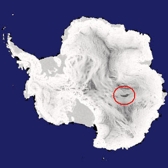
    British scientists discovered that rivers, size of major European rivers are at a depth of hundreds of feet beneath the Antarctic ice.

    The discovery puts in check the theory that the lakes subglaciais developed over millions of years with autonomy, and that theoretically could harbor primitive forms of life, that would have evolved independently. According to some researchers suggest, if there are microbes in glacial lakes, could also exist in jupiteriana moon Europa or in underground lakes of Mars.

    Another consequence of the discovery drill is to review in the deserts of Antarctic ice, with the intention of studying the lakes under the polar cap, where it is believed that there is life.

    Previously it was thought water moves under the ice through slow infiltration. But the new findings show that cyclically the lakes beneath the ice cap "overflow", causing massive floods that travel hundreds of miles.

    According Duncan Wingham, scientist in charge of the team of researchers responsible for the discovery, "the biggest concern is that delaying the drilling of the lakes is the fear that the equipment may include some microbes from the surface there. The models indicate that any contamination will not be restricted to one lake. "

    Using the satellite ERS-2, the European Space Agency, ESA, the scientists measured with great precision the oldest layers of ice and the thick Antarctic continent and found changes in synchronized altitude areas, separated by up to 290 km. According to scientists, the only possible explanation for this change would be the existence of large flows of running water under the ice, and that transfer water from a lake to another.

    The discovery of rivers subglaciais creates new speculation that the Lake Vostok, approximately 5,400 cubic km of water - enough to supply Sao Paulo(10 million people) by at least 5 thousand years - may have, historically, produced flooding large enough able to reach the mainland coast.

    Last edited by joćo paulo; 01-03-2009 at 05:56 PM. Reason: Oops...
    http://www.cartographersguild.com/signaturepics/sigpic3377_5.gif

  9. #9
    Community Leader NeonKnight's Avatar
    Join Date
    Aug 2007
    Location
    Surrey, Canada, EH!
    Posts
    5,051

    Default

    I think your translation may be a little off there joćo paulo.

    I think it may be hundreds of feet, not hundreds of miles.

    From the following website:

    http://www.livescience.com/technolog...rth_drill.html

    The Earth's radius is about 4,000 miles (6,400 kilometers). The main layers of its interior are in descending order: crust, mantle and core.

    The crust thickness averages about 18 miles (30 kilometers) under the continents, but is only about 3 miles (5 kilometers) under the oceans. It is light and brittle and can break. In fact it's fractured into more than a dozen major plates and several minor ones. It is where most earthquakes originate.
    But still, cool information know.
    Daniel the Neon Knight: Campaign Cartographer User

    Never use a big word when a diminutive one will suffice!

    Any questions on CC3? Post them with CC3 in the Subject Line!
    MY 'FAMOUS' CC3 MAPS: Thunderspire; Pyramid of Shadows; King of the Trollhaunt Warrens; Demon Queen's Enclave

  10. #10

    Post

    Quote Originally Posted by Redrobes View Post
    joćo paulo has pointed out that the largest island where a river has forked around it is a mere 20 square kilometers.
    http://www.cartographersguild.com/sh...28&postcount=3
    This river is going through its very temporary meanderings to find one course through this region. One day soon one side will dry up. In any case 20 square km is very small.
    The link that JP gives in his post actually says the island is 19,000 square kilometers (~12,000 square miles).

    The Bananal Island covers an area of 19,162.25 km², twice the size of Lebanon or Jamaica. It is the largest fluvial island in the world being 350 km long and 55 km wide.
    From http://en.wikipedia.org/wiki/Bananal_Island

    That seems pretty large to me, but, granted, that is a rarity. The largest one I know of is about a square mile and most are a few feet.

Page 3 of 15 FirstFirst 123456713 ... LastLast

Tags for this Thread

Posting Permissions

  • You may not post new threads
  • You may not post replies
  • You may not post attachments
  • You may not edit your posts
  •