Reply With Quote
What an adventure! That sounds like a wonderful way to commemorate. I'm new and learning so I can't give much in the way of advice. Are you going to bind them into a book at the end, or hang them up?


Hello!
I have two hobbies - wandering and drawing maps. Some time ago I decided to combine them and draw maps of each of my longer wanderings. I tried to draw with photoshop and tablet ( example here), but it did not please me, so I decided to draw by hand.
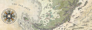
In 2014 I wandered from Poland to Nimes in France (circa 2500 km). Now I decided to commemorate this trip by drawing a series of maps (probably about 30) in the scale 1:200000. Plenty of work.Today I finished the first sheet.
Attachment 109771
Attachment 109769
Attachment 109770
What do you think about it? Do you have any advice for me? Do you want to see the whole process of creating a single map sheet?
And I realy need some critique or feedback!

What an adventure! That sounds like a wonderful way to commemorate. I'm new and learning so I can't give much in the way of advice. Are you going to bind them into a book at the end, or hang them up?
This is wonderful!
"We are the music makers, and we are the dreamers of dreams"
It's superb !! I'm in love with absolutely everything here, from linework to color : so, so lovely ! o_o
That is magnificent and the style really well emulated ! Beautiful work in the making
Thank you very much!
After finishing the work, I want to scan and print all sheets as a book (a gift for my nephews, who love to listen about my travelsOriginally Posted by Compass Rose

OK, let's start next sheet.
Tools
- hard pencil (9H)
- eraser
- 003 pen marker (black)
- 005 pen marker (black)
- 01 pen marker (black)
- 04 pen marker (black)
- brushmarker (black)
- brushmarker (red)
- ruler
- circinus
- thin watercolor brush
- watercolor paints
- big brush for clearing eraser shavings
Attachment 109827
Paper
30x40 cm 300g/m2 for watercolour painting
Margins
2,5 cm on each side. That's enough for a frame, which I'll draw at the end
Towns and villages
Because I have to map the real terrain, I start with google maps. I measure the distance between the extreme points of the terrain using a ruler (Google map option). On my maps, 1 kilometer is 5mm. So the distance between cities in kilomerts I divide by 2 and the result is the distance in centimeters on map.
At the beginning I mark the town, where I started the journey, then the town, where I finished it (or the nearest).
I also choose the corner, where I will put the title and the wind rose.
Then I mark all towns, villages and hamlets between.
Attachment 109828
NOTE: If you create a fantasy map, you can start a sketch from anything - rivers, mountains, roads - but after sketching, when you grab a pen, I strongly recomended start drawing from cities and their names.
Then I draw with a 005 pen the towns on the marked points. Next I shade with a 003 pen. It's easy, just practice it.
Attachment 109829
At the end I write the names of towns (01 pen) and villages (005 pen). I leave the little settlements off my trail without a name to make the map more readable
Attachment 109830
I wait a few minutes to let the ink dry and erase traces of the pencil under the settlements.
***
I'm going back to drawing. Next episode tomorrow
Last edited by Qmoh; 08-30-2018 at 06:49 PM.
Very nice! I'm really looking forward to following this!
I love the style! It reminds me a great deal of Matthew Paris' map of England!
I'm rather inspired by Nicholas Bellin and Edward Hasted
Let's move on
Roads
I check on gogle maps the course of major roads in the region and I apply them with a pencil. Then, with a 01 pen, I draw them. Piece of cake.
Attachment 109835
Rivers and lakes
I do the same in the case of rivers and lakes, however, I use a thin penbrush, because it is more irregular. I draw rivers wider than in reality, because it looks nicer.
Then I draw with 003 pen the current of the rivers and waves of the lakes.
Attachment 109836
Hiking path
The next step is to mark (red brushpen) the route of my journey on the map. The dots mean camping. Easy.
Attachment 109837
Forest
I check on Google maps the distribution of forests in this region and I draw (005 pen) the contours of trees in these areas. Then I lightly shade the forest area (003 pen).
Attachment 109839
And now the map looks like this.
Attachment 109840
In the next episode: farmlands, meadows, swamps and details.
Farmlands, meadows, swamps and details
Now the most tedious part of the job - details. First I draw (003 pen) the crop fields, then the meadows, and finally the dots, short lines and small curves as a background. Boring, but you have to do it slowly.
Attachment 109865
Wind rose
I draw four wheels with diameter 6cm, 5cm, 3cm, 1cm. Then with a ruler and a 9H pencil I draw a sketch of windrose. When the shape is ok, I finish it with a pen (01, 04, brush pen).
Attachment 109866
Come, paint my world
I apply a small amount of watercolors with a thin brush.
Attachment 109867
Be careful not to give too much or too little pigment.
Attachment 109868
Almost done. In the next episode: border frame and map title.
 Posting Permissions