Click Here For Zoomable Map
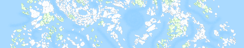
This map of "Una the Infinite Archipelago". Depicting a never ending sea of islands floating in the sky. I have been trying to differentiate sky from sea by color, and have failed for years. This is my attempt to convey "air" by using dark colors. "Nightmoding" the entire map.
About the Map
This is the second iteration of the map I have posted here.
The islands of this map were hand drawn individually using a XP-Pen tablet in the current edition of
Inkscape.
Since my last posting about this map I no longer use GIMP for any editing. I have much better equipment, and that is no longer necessary.
Additionally, I cut the exported image into 1024, 250 x 250 images and stitched them together as a zoomable google maps like map.
The splitting of the images was done with a freeware tool called "
Tile Mage". (site is a little sketchy, be careful)
I used another freeware tool called "
Bulk Rename Utility" to rename the files.
I then used the Leaflet library to make a the zoomable map.
I have reduced the file source to about 7.8MB, which have proven much more manageable. Although, there are still thousands of individual objects and labels
About the Map
Here are the features of the new map.
Windwalls - My world has walls of wind that are difficult to traverse by airship. Windwall labels have been rotated to point in the direction the wind blows.
Skylands - The many islands on the maps are called "
skylands". A majority of the skylands on the map have names. It is a long term goal to name all of them, although I consider the map complete without all of the labels.
Skyland Outline Color - The color of each skyland outline determines the
color of the
gemin inside of it. There are 10 colors of skyland core, these indicate the biome of the skyland, as well as its surrounding weather. The color of each core is random. I colored them by rolling a d10 (ten-sided die) over 2500 times.
Skyways - There are multiple types of skyway, which are the long dotted sections. There are two kinds marked. One with light blue dots which indicate skyways that have
buoys. The other have dashed dark spaces, which are unbuoyed.
Cities - Every port city with a population greater than 250,000 is labeled. There are markers indicating cities with 500,000 or more and 1,000,000 or more residents.
Parks - Green islands are biomes that grow many trees. Some park areas have been labeled as to their purpose with green text. Islands that contain more than 50% forest have also been colored green.
Interest - Dark teal labels many mark many areas of interest, natural geological, and meteorological structures such as windwalls, areas of high wind difficult to pass, and drifts which move both islands and ships.
Hazards - Red labels indicate dangerous locations and places to avoid. This map extends the hazard concept to "circles" which indicate the area effected by the hazardous zones.
If you have any questions about the map, its world, or its construction. Feel free to ask here.

 Reply With Quote


Originally Posted by SoaringMoon

 Posting Permissions